


Phone vs. Computer
 08-21-16 | 03:51 PM
#1
Thread Starter
Member
Joined: Jun 2015
Posts: 27
Likes: 0
From: Oakland, CA
Bikes: Trek 7.4fx, Motobecane Ti LeChampion
Phone vs. Computer
I'm thinking about getting some kind of device for my bike. Primarily, I'd like to use it for GPS/navigation. I lead occasional group rides or sometimes like to try new routes. Currently, I have the routes loaded onto my phone which I store in a ziplock in my jersey pocket. Whenever I'm uncertain about where to go, I'll stop and do a check, but I hate making frequent stops when there are multiple short turns.
So I'm thinking about simply getting a bike mount, like the quad lock. It's pricey but seems to do the trick.
Here's my question: if I mount my phone, are the vibrations going to mess it up over time? I have an iphone 6s plus which has great battery life (great for long rides) but some people claim the rattling is bad for the camera/motherboard, etc. Anyone have any experience with this?
A second noob question: Do the GPS computers have any advantage over simply using a phone w/ a bike fitness app? I thought it might be price, but those computers aren't particularly cheap and since I have to carry my phone anyway, I hate to have to be laden down with multiple devices.
Another option I've been mulling over is a fitness watch (maybe the Apple Watch 2 when it comes out). Most don't offer directions/navigation alerts...
Thanks for your time!
 08-21-16 | 06:07 PM
#2
Senior Member


Joined: Jul 2007
Posts: 8,596
Likes: 3,525
From: South shore, L.I., NY
Bikes: Trek Emonda SL7, Cannondale Topstone, Miyata City Liner, Specialized Chisel, Specialized Epic Evo
The phone will do what you want, some folks find that RideWithGPS works very well. Battery life may not be as good on a phone as with a dedicated cycling GPS unit, kind of phone dependent. As well, you may be needing a constant data connection to use the phone, while a GPS unit has the maps and course loaded on the device. There are work around a for this, as BTW and I'm uncertain as to this.
Others find the phone screen is hard to read in direct sunlight, but the larger phone screen may be easier to read. Then there's the argument about do you want your $600 phone on the h-bar, as opposed to a $250 GPS unit, and this begs the question do you rely on the phone for a lot of other things that would screw you up if the phone got wet. Yes you can get a Lifeproof or Otterbox case, but would you use that daily ?. Garmin GPS units are typically waterproof as BTW. The Garmin units that use a touch screen - so 810,820 & 1000 work well with full fingered gloves, so work in colder weather, where as a phone screen requires taking a glove off or using special gloves.
One neat trick I leaned today is from this post.
https://www.bikeforums.net/road-cycli...awesome-3.html
Seems the Garmin watch, not sure what model, can accept a downloaded course and will buzz, etc.. before turns. The post indicated the use of a dedicated Garmin 800 unit as well to show the course on a map.
I've been very happy with a Garmin 810 for turn-by-turn directions on courses I pre created in Garmin Connect. It's been very reliable for me, though TBT sometimes lags in complicated intersections with fast turns in close proximity. Not sure any other device is any better. An $810 runs about $250 these days. Others have found the 810 flaky, maybe the 820 is better, but first generation Garmin devices usually have issues, just heads up. I've 4 mos. on an 810 and 50+ rides with no issue, so maybe the software is now stable.
I'm also using my 810 as the only bike computer on multiple bikes, so the investment will pay off as I no longer need to buy replacement Cateyes when they fail. As well I already have and carry a phone anyway, so it's not an issue. With the Garmin 81o/820/1000 as well as the Wahoo units, you can create the course on a computer, save, then easily download off the Garmin phone app to the bike GPS unit via the BT connection. It's very easy. After a ride, you stop the course and ride and press save and it uploads to Connect, RWGPS and Strava automatically. I'm in love with this ride recording system.
Last edited by Steve B.; 08-21-16 at 06:18 PM.
08-21-16 | 08:31 PM
#3
Senior Member
Joined: Apr 2010
Posts: 684
Likes: 8
From: Jersey City, NJ
Bikes: Jamis Coda Elite - custom 1x9 setup
i just installed a generic quad lock and it's super easy to mount and i would certainly not call it pricey.
i don't use my phone on the bike much but researched for awhile between the two options - having a dedicated garmin-like unit and just using my phone. fyi it is possible to use offline maps with some phone mapping programs such as one of the best - google maps. you can pre-select areas on the map to load for offline use.
i like google maps because it has dedicated bicycle directions that take into account local bike infrastructure. and since it's google maps, they are updated constantly and for free. the main reason i don't like the phone is because it chews through battery. and while i usually carry around a 10,000 mah batter with me on longer rides, it's a pain to charge the phone while riding - easy enough when stopped.
i have not used my phone enough to conclude whether the shaking and rattling is affecting it. on the flip side i have yet to find a post or article where someone says their phone was damaged by using it on a bike.
08-22-16 | 07:09 AM
#4

Senior Member
Joined: Sep 2015
Posts: 342
Likes: 0
From: Atlanta
Bikes: Trek FX 7.4 + Sirrus Expert Carbon X1
I have been debating to get a bike computer or use my phone.
One feature I like on my phone is that the app will announce my stat at every mile that I tell it to and it sit at the back of my saddle. I can hear the audio on my hr zone change too.
However I end up putting my phone on my pant as I like to take pict and show off the scenery on FB.
No bike computer for now.
08-22-16 | 08:59 AM
#5

Senior Member
Joined: Nov 2015
Posts: 415
Likes: 0
From: Black Hills, SD
Bikes: Montague Para Trooper High line
I tried using my phone for GPS as well as to record my ride and switched to a dedicated bike computer because using the phone for bike related rides, especially GPS kills the battery charge and harder to see in bright light. Yes the phone will work but a dedicated GPS in my experience is the better option if you have the extra $ to spend.
08-22-16 | 09:57 AM
#6
Senior Member
Joined: Jul 2007
Posts: 8,596
Likes: 3,525
From: South shore, L.I., NY
Bikes: Trek Emonda SL7, Cannondale Topstone, Miyata City Liner, Specialized Chisel, Specialized Epic Evo
I used to use my iPhone with Endomondo, a Dutch based fitness app. In theory Endo would also allow me to log my swim workouts, even if it sucked at it. The bike ride app used the phone GPS and would easily port to the web. It was OK for what it was. I tried RideWithGPS as well as MapMyRide, but neither tracked swimming well or at all. I also never liked Strava as privacy configuration was marginal and hard to configure.
I finally got fed up with Endomondo, having to manually enter the swims in percentage of a mile, which is a PITA when you typically think yards or meters if swimming in a pool. Then I discovered the Garmin swim watch, which dumps the saved workout right to Garmin Connect via a BT sensor on my laptop. Then I opted to try GPS routing on the bike and am now sold on Garmins systems. They are far from perfect but as good as anything else I've tried. Tracking workouts, which I've been doing for 27 years, is now painless. When I got the 810 I pulled all my Cateyes off my bikes and just use the Garmin, which I found to be accurate to .6 miles in 100 compared to my conventional Cateye. You pay a price for all this, but it dos make life easy. Garmin Connect is also as god as RideWithGPS for creating routes, as well.
The only accessories I've purchased are additional out-front mounts for the 810 on a few bikes, makes it easier to see the unit (15 ea.), as well as 2 Garmin speed sensors. I use one on my go fast bike for better speed accuracy when doing fast group rides, the 2nd was for a mt. bike to get better ride mileage and speed accuracy when using deep in the woods. I really don't need the speed sensors, but it's easy to get caught up in the upgrade while it's on sale bug.
Last edited by Steve B.; 08-22-16 at 10:01 AM.
08-22-16 | 10:19 AM
#8
Senior Member
Joined: Mar 2010
Posts: 23,208
Likes: 10,653
From: Seattle, WA
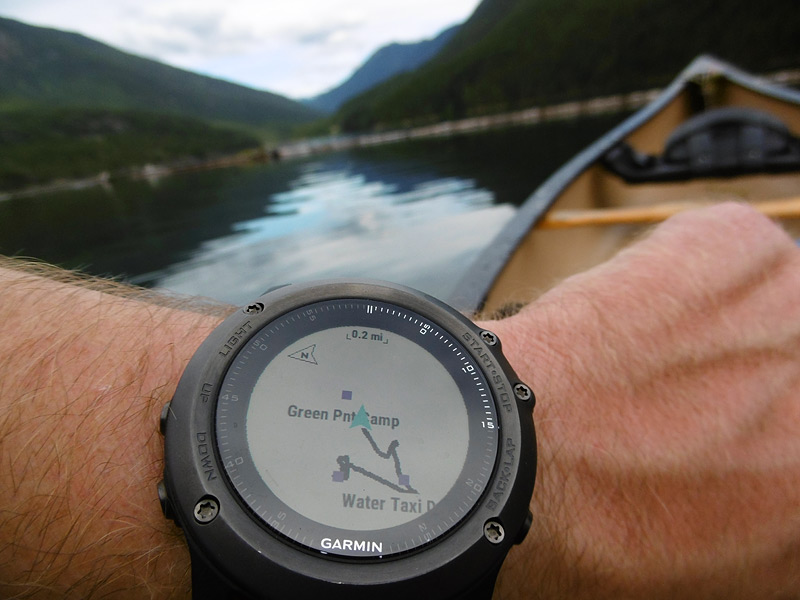
Here's an elevation chart showing what I've done and what's ahead of me on my route - the red arrow points in the direction I need to go (you can see it's pointing ahead on the road).

And basic mapping, better for hiking than for cycling.
 08-22-16 | 04:53 PM
#9
Senior Member
Joined: Apr 2010
Posts: 684
Likes: 8
From: Jersey City, NJ
Bikes: Jamis Coda Elite - custom 1x9 setup
does Garmin GPS Routing take into consideration bike infrastructure? like how on Google Maps you can select Bicycle and it will populate bike lanes in green lines on the screen
08-22-16 | 05:16 PM
#10
Senior Member
Joined: Jul 2007
Posts: 8,596
Likes: 3,525
From: South shore, L.I., NY
Bikes: Trek Emonda SL7, Cannondale Topstone, Miyata City Liner, Specialized Chisel, Specialized Epic Evo
In essence and as I understand it, what's being created in Connect is GPS location points and those get loaded to the device, which then overlays the points onto whatever map set you choose to use on the device. It works well.
Thus while the course created on a computer using Connect and while viewing on Google Maps, gets shown on the device on the OSM maps. It still routes into a bike path just fine, so go figure.
You can as well create courses using RideWithGPS which can be downloaded to a device. It does this with a cable connection of device to unit, as opposed to the BT transfer with courses from Connect. It's slower to have to do a physical connection of the device, for me at least, thus I like the BT and have gotten good at using course craation on Connect.
08-22-16 | 05:52 PM
#11

Senior Member


Joined: Nov 2014
Posts: 27,576
Likes: 5,451
From: Eugene, Oregon, USA
I'm not sure about the effect of rattling on my phone, but falling out of the shirt pocket at 30 MPH didn't help it.
Strava/RideWithGPS chews up batteries. I'm working on getting another extended battery, and hopefully that will help some.
USING GPS for speed leaves a little to be desired, but the end of ride tracking can be nice. RideWithGPS elevation seems to be off by quite a bit, especially the live elevation change. Strava seems to do better, but only has post ride processing of elevation data (at least for free users).
 08-22-16 | 06:48 PM
#13
Thread Starter
Member
Joined: Jun 2015
Posts: 27
Likes: 0
From: Oakland, CA
Bikes: Trek 7.4fx, Motobecane Ti LeChampion
Thanks all. I think I am going to get a quadlock. I don't use GPS enough to justify something more than $175 and there don't seem to be any products in that range that does navigation. I'll keep an eye out for battery life. That's one thing I love about larger phones like the iphone 6s plus. Given its size, its battery lasts for hours.
08-22-16 | 07:00 PM
#14

Senior Member
Joined: Aug 2012
Posts: 55
Likes: 0
From: Long Beach, CA
Bikes: 1998 Cannondale F900
I had a mid ranged sigma wireless computer bc1609 for a year. Worked great until I ran into the problem of headlight interference. Dealbreaker for me.
I then went to the Garmin Edge 800 bundle, (Ant+ has no electrical interference from lights).
All was well but I realized I could sell the edge and with that money buy a quadlock, Bluetooth HRM with money to spare.
That's where I've been for the past couple of years. No regrets at all. No worries about my iPhone 6 surviving a crash in the quadlock case. The newer iPhones have built in barometric altimeters and Cyclemeter app will recognize + display those metrics.
The only thing I miss is the onboard thermometer on the Garmin.
I don't carry additional battery packs unless I'm touring. I can go for a 4-5 hour ride with screen on, running cyclemeter, playing music via bluetooth and come home with 30-40% battery left on an iPhone 6 (not plus model)
I can't speak for the iPhone6+ battery life. They do have much larger internal batteries, but are running many more pixels if you leave the screen on.
Last edited by EricSteven5; 08-22-16 at 07:12 PM.
08-22-16 | 07:10 PM
#15
Senior Member
Joined: Apr 2010
Posts: 684
Likes: 8
From: Jersey City, NJ
Bikes: Jamis Coda Elite - custom 1x9 setup
When using and creating courses in Connect, you can choose to view and create in Open Street Maps or Google Maps. Google shows bike paths and will allow a course to be created using paths, which I haven't been able to do with the Connect OSM maps. Odd thing is the device itself can use a number of different maps, it doesn't actually come with anything useful loaded. You can buy from Garmin the same maps they use on auto navigators. Or you can get free maps, thus one of the first thing I did was download to the 810 the free North American Open Street Map set, onto the unit SD card. DC Rainmaker has good instructions how to do this.
In essence and as I understand it, what's being created in Connect is GPS location points and those get loaded to the device, which then overlays the points onto whatever map set you choose to use on the device. It works well.
Thus while the course created on a computer using Connect and while viewing on Google Maps, gets shown on the device on the OSM maps. It still routes into a bike path just fine, so go figure.
You can as well create courses using RideWithGPS which can be downloaded to a device. It does this with a cable connection of device to unit, as opposed to the BT transfer with courses from Connect. It's slower to have to do a physical connection of the device, for me at least, thus I like the BT and have gotten good at using course craation on Connect.
what I need to test now that i have the quad lock mount is whether or not Google Maps will purposely auto-route you on as much bike infrastructure as possible anytime you set a new destination while riding - rather than only doing that with pre-configured routes. should be easy to find out in NYC where there are bike lanes everywhere.
08-22-16 | 07:14 PM
#16
Senior Member
Joined: Aug 2012
Posts: 55
Likes: 0
From: Long Beach, CA
Bikes: 1998 Cannondale F900
thanks for the detailed response.
what I need to test now that i have the quad lock mount is whether or not Google Maps will purposely auto-route you on as much bike infrastructure as possible anytime you set a new destination while riding - rather than only doing that with pre-configured routes. should be easy to find out in NYC where there are bike lanes everywhere.
what I need to test now that i have the quad lock mount is whether or not Google Maps will purposely auto-route you on as much bike infrastructure as possible anytime you set a new destination while riding - rather than only doing that with pre-configured routes. should be easy to find out in NYC where there are bike lanes everywhere.
This was one of my other reasonings for abandoning the Garmin - Their maps and routing are not at all (quite surprisingly) tailored to cycle friendly routes)
I'm often out running errands and didn't have a pre-made route made (and then uploaded) to the Garmin to the impromptu destination.
Last edited by EricSteven5; 08-22-16 at 07:18 PM.
08-23-16 | 05:06 AM
#17
Senior Member
Joined: Jul 2007
Posts: 8,596
Likes: 3,525
From: South shore, L.I., NY
Bikes: Trek Emonda SL7, Cannondale Topstone, Miyata City Liner, Specialized Chisel, Specialized Epic Evo
Here's an attached screen shot of what you see on Garmin Connect. The green lines are all NYC cycling infrastructre. When you are creating a course and selecting a path, the program will route and save a path selection. When loaded to the device, it directs you onto that path. I've tried this on the bike path at Jones Beach, in NY.
08-23-16 | 05:37 PM
#18
Senior Member
Joined: Apr 2010
Posts: 684
Likes: 8
From: Jersey City, NJ
Bikes: Jamis Coda Elite - custom 1x9 setup
Google Maps with bicycle route selected will indeed re-route. Just as it would with car directions.
This was one of my other reasonings for abandoning the Garmin - Their maps and routing are not at all (quite surprisingly) tailored to cycle friendly routes)
I'm often out running errands and didn't have a pre-made route made (and then uploaded) to the Garmin to the impromptu destination.
This was one of my other reasonings for abandoning the Garmin - Their maps and routing are not at all (quite surprisingly) tailored to cycle friendly routes)
I'm often out running errands and didn't have a pre-made route made (and then uploaded) to the Garmin to the impromptu destination.
08-23-16 | 08:41 PM
#19
Senior Member
Joined: Apr 2010
Posts: 684
Likes: 8
From: Jersey City, NJ
Bikes: Jamis Coda Elite - custom 1x9 setup
Did another routing test on Google Maps in NYC and it passed with flying colors - gave me directions perfectly coinciding with the mapped bike infrastructure. For anybody in an urban environment with bike infrastructure who likes to go on adventures in the city, explore and be spontaneous as well, you can't beat Google Maps on the phone. Now you just need a phone with a great battery 
08-23-16 | 10:54 PM
#20
Me duelen las nalgas
Joined: Aug 2015
Posts: 13,519
Likes: 2,832
From: Texas
Bikes: Centurion Ironman, Trek 5900, Univega Via Carisma, Globe Carmel
An external battery pack/charger like the Jackery will extend the use of your smart phone and other devices. I started toting one a couple of weeks ago after seeing another cyclist using one during a group ride. Works with my iPhone, Ion Speed Pro video camera, and USB rechargeable bike lights. The only tricky bit is remembering to click the on/battery check button once after hooking up the cable.
I use a couple of Lowepro lens pouches Velcro'd across my handlebar to hold the battery pack and other devices I want to keep handy. The charger cable snakes through the bag with the zipper nearly fully closed. As long as it isn't raining it's fine to run while riding. If the weather looks bad I'll use the weatherproof seal on the back of the Ion Speed Pro, and put the phone, battery pack, etc., into ziplock bags. I can still operate the phone touch screen through a ziplock bag.
I use a couple of Lowepro lens pouches Velcro'd across my handlebar to hold the battery pack and other devices I want to keep handy. The charger cable snakes through the bag with the zipper nearly fully closed. As long as it isn't raining it's fine to run while riding. If the weather looks bad I'll use the weatherproof seal on the back of the Ion Speed Pro, and put the phone, battery pack, etc., into ziplock bags. I can still operate the phone touch screen through a ziplock bag.
08-24-16 | 09:19 AM
#21
Senior Member
Joined: Mar 2010
Posts: 23,208
Likes: 10,653
From: Seattle, WA
08-24-16 | 09:24 AM
#22
Banned
Joined: Jun 2010
Posts: 43,586
Likes: 1,380
From: NW,Oregon Coast
Bikes: 8
Low on the tech addiction scale , I used a wired computer to count the miles on cycle-tours .
Daily rides I just ride the bike.. no widgets needed .. nothing to steal, while I park the Bike.
OP is in the Tech Bubble with High priced housing , good luck with that IT Career.")
./.
Daily rides I just ride the bike.. no widgets needed .. nothing to steal, while I park the Bike.
OP is in the Tech Bubble with High priced housing , good luck with that IT Career.
./.
Last edited by fietsbob; 08-24-16 at 09:30 AM.
08-24-16 | 10:50 AM
#23
Senior Member
Joined: Apr 2010
Posts: 684
Likes: 8
From: Jersey City, NJ
Bikes: Jamis Coda Elite - custom 1x9 setup
An external battery pack/charger like the Jackery will extend the use of your smart phone and other devices. I started toting one a couple of weeks ago after seeing another cyclist using one during a group ride. Works with my iPhone, Ion Speed Pro video camera, and USB rechargeable bike lights. The only tricky bit is remembering to click the on/battery check button once after hooking up the cable.
I use a couple of Lowepro lens pouches Velcro'd across my handlebar to hold the battery pack and other devices I want to keep handy. The charger cable snakes through the bag with the zipper nearly fully closed. As long as it isn't raining it's fine to run while riding. If the weather looks bad I'll use the weatherproof seal on the back of the Ion Speed Pro, and put the phone, battery pack, etc., into ziplock bags. I can still operate the phone touch screen through a ziplock bag.
I use a couple of Lowepro lens pouches Velcro'd across my handlebar to hold the battery pack and other devices I want to keep handy. The charger cable snakes through the bag with the zipper nearly fully closed. As long as it isn't raining it's fine to run while riding. If the weather looks bad I'll use the weatherproof seal on the back of the Ion Speed Pro, and put the phone, battery pack, etc., into ziplock bags. I can still operate the phone touch screen through a ziplock bag.
There is clearly a market for directional assist both in driving and bicycling - hence why GPS apps are so popular in cars and now bicyclists. Glad you know everywhere you want to go, not everybody does. Hence a stupid argument.
08-24-16 | 10:55 AM
#24
Senior Member
Joined: Mar 2010
Posts: 23,208
Likes: 10,653
From: Seattle, WA
I don't know everywhere I want to go, I just know that planning ahead is in fact better than relying on Google Maps. You said "you can't beat Google Maps" and now you're upset that somebody has a differing opinion.
08-24-16 | 02:01 PM
#25
Senior Member
Joined: Apr 2010
Posts: 684
Likes: 8
From: Jersey City, NJ
Bikes: Jamis Coda Elite - custom 1x9 setup
Nope. I said that way is not a one size fits all and gave an example . He dismissed GPS altogether really. That's like saying who needs GPS for anything, just learn how to ride-drive everywhere by heart.
Last edited by idiotekniQues; 08-24-16 at 02:06 PM.