


Computer vs GPS
 04-11-07 | 05:43 AM
#1
Thread Starter
Senior Member
Joined: May 2005
Posts: 216
Likes: 0
From: SE Pennsylvania
Bikes: Vintage French road bikes, older "rescue" mountain bikes
Computer vs GPS
Bought a bike about a year ago (used) that has a Cateye computer on it. Works reasonably well, except that one of the wires came loose (or I guess that's what's wrong), and it now only senses the pedals, not the wheel any more. Thinking about chucking it and using a GPS instead - gives most of the info I want - speed, distance travelled, etc, and far less complicated to use as well. Also no pesky/ugly wires running up and down the tubes, not to mention the sensors. Anybody have experience with a GPS on a bike? They make special brackets to mount a standard unit (which I already have) on the handlebars.
 04-11-07 | 07:19 AM
#2

crusty
Joined: Aug 2005
Posts: 309
Likes: 0
From: Guelph, ON
Bikes: Giant Kronos, Miele Appolo, Miele 12 spd, Diamondback Hybrid
I never really care how fast I'm going but I like to know where I've been and the rest of the data when I get into the house. I carry the GPS in my seat bag and check the information afterwards.
04-11-07 | 10:02 AM
#3

I have a Garmin etrex that I got five or six years ago. No maps, but it has waypoints. Handles speed, distance, compass as well as the data from GPS - elevation, time, sunrise/sunset. I got a handlebar mount last summer. I've used a bike computer before too.
GPS does everything a bike computer does, but I don't use it nearly as often. It takes some time to lock on to satellites, so it's no good for short trips. It's heavier to carry around if I lock up and go inside somewhere, and it's more valuable for someone to steal. It's not made to be a bike computer, so there can be a lot of awkward button presses to get to the numbers you want.
It's nice to not have to worry about a sensor or calibration though.
Since it doesn't have maps, the most I get is an arrow. If you've played GTA1 or 2, you know how that can mess you up. If you rely on it for directions, you can wind up on bad roads or dead ends. It's nice to have a destination, though - I can input latitude and longitude from Google Maps and it will point me exactly to that spot I saw on the satellite view.
04-11-07 | 10:38 AM
#4
Full Member

Joined: Jul 2004
Posts: 212
Likes: 3
From: Harvest, AL
Bikes: Trek 1000C, Raleigh M50
Like CaptainCool, I also have a non-mapping Garmin Etrex.
GPS Pros:
No calibration.
Speed, distance, avg speed all available.
Backlight.
Can get you back to where you started, regardless of how lost you are.
Tracks can be downloaded into computer for analysis. (Requires additional software)
GPS Cons:
May require several minutes to acquire satellites.
May require several awkward button presses to get data you want.
No odometer function. (It does have a trip odo).
No auto start/stop function based on wheel motion.
If I'm going somewhere unfamiliar, I'll use the GPS. Otherwise, the Cateye on my roadie is easier. However, the computer on my commuter bike has recently failed, and I'm going to use the GPS instead of replacing it.
04-11-07 | 12:45 PM
#5
Senior Member
Joined: Jul 2006
Posts: 2,418
Likes: 1
Originally Posted by fritz1255
Bought a bike about a year ago (used) that has a Cateye computer on it. Works reasonably well, except that one of the wires came loose (or I guess that's what's wrong), and it now only senses the pedals, not the wheel any more. Thinking about chucking it and using a GPS instead - gives most of the info I want - speed, distance travelled, etc, and far less complicated to use as well. Also no pesky/ugly wires running up and down the tubes, not to mention the sensors. Anybody have experience with a GPS on a bike? They make special brackets to mount a standard unit (which I already have) on the handlebars.
04-11-07 | 01:25 PM
#6
Senior Curmudgeon
Joined: Jun 2006
Posts: 367
Likes: 0
From: Tejas
Bikes: Miyata, Fuji
I have a garmin GPS with Mapsource program. You can build routes on the pc, and download them to the GPS in very few minutes. Then on the route the thing beeps .1 mile before each turn with arrow displaying turn direction, then beeps again at 100 yards. YOU CANNOT GET LOST.
If you just wander, you can upload where you have been via the trail left into the pc for future reference. My has vertical speed as well, altitude of course. It is also a good check for your given distances on your computer. It is far more accurate.
When I am alone in strange territory(INCLUDING $$ RIDES where I preload the route), or going with the group on a first time route I use it, otherwise it stays home.
For me this is one of the greatest toys available. I just cannot understand why any biker would want one without the full mapping functions and display. To each his own I guess.
04-11-07 | 03:25 PM
#7
Walmart bike rider
Joined: Aug 2004
Posts: 2,131
Likes: 34
From: South Carolina
Originally Posted by bemoore
GPS Cons:
May require several minutes to acquire satellites.
May require several minutes to acquire satellites.
No odometer function. (It does have a trip odo).
No auto start/stop function based on wheel motion.
Now there are places where a GPS isn't always going to be the best & a cyclometer is preferred. In dense forest, downtown environments and deep canyons, reception can be spotty. Also if you go into a long tunnel. But if you are on a road, 99.99 percent a GPS will give you a good signal.
If you ever download a ride into a mapping program from a handheld GPS, you'll never ride without one again. I merge all my rides together and I can view a map to see what roads I have never ridden on.
One other reason to use the Garmin mapping units is they have a computer screen that will show up to 8 different data at one time. I can view my MPH, avg speed, current time, odometer, trip odometer, distance to next, elevation speed and sunset.
Now a downside is if you buy a mapping unit, it will only come with a very basic basemap... Basic meaning only US highways, interstates, and major state routes. If you want specific streets for your area, you've got to buy their mapping software... usually around $100 more....
Since cyclometers are cheap, I would suggest perhaps using both.
04-11-07 | 07:51 PM
#8
Thread Starter
Senior Member
Joined: May 2005
Posts: 216
Likes: 0
From: SE Pennsylvania
Bikes: Vintage French road bikes, older "rescue" mountain bikes
Thanks for the help! I also have a basic Garmin Etrex. I bought it for biking and hiking, mostly to see how fast I had gone and how far rather than to map out routes. I usually have where I am going fairly well planned out before I go, so it is all I need. Interestingly enough, the GPS works on planes when help up right against the window - gives the correct altitude and ground speed.
On the same subject (kind of): Where do you think that GPS technology is headed? My feeling is that within 5 years or so, everyone (or everyone who has a cell phone now) will have something like a blackberry that incorporates GPS and mapping technology along with a phone and mini-computer.
On the same subject (kind of): Where do you think that GPS technology is headed? My feeling is that within 5 years or so, everyone (or everyone who has a cell phone now) will have something like a blackberry that incorporates GPS and mapping technology along with a phone and mini-computer.
04-11-07 | 09:39 PM
#9
Senior Member
Joined: Jun 2004
Posts: 3,811
Likes: 0
From: Northern Nevada
This is WAY too much information for me. I use my GPS (low-end Garmin, I forget the model) very occasionally on mountain bike trips--I live near the Tahoe National Forest and you can still get lost in there sometimes. On the roadie, I much prefer a big-scale AAA map and a basic computer, just time, speed and distance. Dunno why everybody's griping about calibration, which is a one-time deal that takes about a minute, and I've never seen a use for a cadence function. If you can't tell how fast you're pedaling, you really need to pay more attention.
04-12-07 | 08:53 AM
#11
e-Biker
Joined: Aug 2006
Posts: 951
Likes: 1
From: Mississauga, Ontario, Canada
Bikes: Gary Fisher, Strong GT-S eBike
My setup:
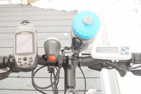
Magellan Explorist 500 on the left. And just in case you're wondering, that's the Bionx (eBike) controller on the right.
I love the Magellan on the bike for several reasons:
1 - Their bike mount is pretty sturdy. If you do crash, the GPS just pops out and bounces on the ground a bit. Not a problem for the Explorist series, they're pretty sturdy. Also the bike mount is easy to install and it positions the screen directly within your view.
2 - The 500 has a color backlit screen. So it's both useable in daytime and nighttime. Backlighting is adjustable.
3 - Built-in geocaching, if you're into that sort of thing. Mountain bikes are great for geocaching.
4 - Track logs are pretty usefull if you need to backtrack and for analysis afterwards. I especially like the fact that it even considers altitude.
5 - Routes are very useful. Every so often I discover some new trail deep in the woods so I simply convert that track to a route so the next time I want to go there I activate that route and follow the directions.
6 - ETA (Estimated time of arrival) is pretty usefull when following a route. That way if you get a cell phone call, you can tell your firends/wife approx. which time you'll be home.
7 - Points of interest are really useful. If you want to visit some location on a trail, just download the POI and map a route to it. Or if you suddenly find something really sweet, just log a POI and then you can download it into the computer later on. Every so often I see something special and take a picture. Then I'll plug in a POI into the GPS just to know where I took said picture. Usefull with google earth.
8 - Speed, distance, odometer (you can reset the odo), avg speed, time, ETA, distance to next waypoint etc. Many options you can select on the active display so it replaces a cycle computer for the most part. I only miss the cadence meter, the rest I can use the GPS for.
And since I have the Bionx, the speedo is built-in so I just glance to the right to see the speed. The GPS is about +/- 0.5 km/h off. Strangely enough, the explorist 500 is dead on with my car GPS (Factory navigation in my Acura). Maybe the Bionx is off? Not sure.
Don't forget that you can use a handheld Explorist for many other things; walking, taking mesurements, car, plane... yes... PLANE, boating (marking fishing spots) etc.
It's a very practical device and very well suited for bikes. Especially those who go deep in the woods.
Edit: Forgot to mention this: I purchased Magellan Mapsend Topo for Canada. So it's not just streets. There's plenty of POIs included as well as geopgraphical data like rivers, streams, trails, parks and the like. Best of all since it's a topo map you get altitude data. So you can actually see the outline of the mountain you climbing. if you suddenly see many altitude lines really close together in front of your position? Watch out... that means a near vertical drop.
Last edited by Zeuser; 04-12-07 at 09:03 AM.
04-12-07 | 10:27 AM
#12
Full Member
Joined: Jul 2004
Posts: 212
Likes: 3
From: Harvest, AL
Bikes: Trek 1000C, Raleigh M50
Originally Posted by Halfast
For me this is one of the greatest toys available. I just cannot understand why any biker would want one without the full mapping functions and display. To each his own I guess.
04-12-07 | 02:18 PM
#14

Software for Cyclists
Joined: Dec 2003
Posts: 4,618
Likes: 0
From: Redding, California
Bikes: Trek 5200, Specialized MTB
Originally Posted by gpsblake
Usually not the case unless you haven't used the unit in a while. I almost always acquire a signal in under a minute.
Other downsides:
Cost (they typically cost 20-30 times what a decent bike computer costs).
Battery Life
Size (though some of the newer models like the Edge 305 are getting smaller).
I think the edge in terms of value still goes to the standard bike computers...but, this may change with the next generation of GPS satellites and receivers.
04-12-07 | 02:31 PM
#15
Biker looking for a ride!
Joined: Nov 2006
Posts: 1,480
Likes: 0
From: Edmond Oklahoma
Bikes: Kuota Kreedo...looking for something different.
The best thing about a GPS period is accuracy and data....
https://biffstephens.motionbased.com
The cons for me are battery life and having to take it from your bike and download the stuff....in a few years they will be wireless in some way....
Not having a map is not that bad....personally I like the bread crumb function and it has helped me get home more than a few times....it is still handy....
I like my GPS and I am all for it...and mine take less then 30 seconds to lock on and I can ride while it is doing it...Garmin 305
04-12-07 | 07:09 PM
#16

Just a student
Joined: Aug 2005
Posts: 277
Likes: 0
From: Yakima, wa
Bikes: Cannondale, schiwin old road bike fuji a unicycle
garmin vista and legend are both good vista cx has color screens and maps and works good at night
you can change information to suit what you need gps is the only way to go plus it gives you elavation
just do it you will be happy
you can change information to suit what you need gps is the only way to go plus it gives you elavation
just do it you will be happy
04-13-07 | 09:28 AM
#17

Originally Posted by bemoore
Cost, maybe? Mapping units can cost as much as a decent bike. I originally got mine for mountain biking, so mapping wouldn't have been useful anyway.
The $200 that my Etrex legend cx cost doesn't come close to the cost of my "decent" bikes, maybe if you added a zero it would be in the ball park of a couple of them.
Your assesment that mapping gps devices are not useful for mountain biking also puzzles me. I would find non mapping type gps devices useless. The maps are great out in the woods where there aren't any street signs and where you might want to know if your close to a road
06-09-07 | 01:13 PM
#18
Senior Member
Joined: Jul 2004
Posts: 13,358
Likes: 665
From: northern michigan
Bikes: '77 Colnago Super, '76 Fuji The Finest, '88 Cannondale Criterium, '86 Trek 760, '87 Miyata 712
I had the Garmin Gecko which is a very basic "get back" and waypoint marker with data readout such as elevation (fun on big declines), mph, trip time, avg's....blah, blah, blah. It costs approx 90.00 or so now if you can find one.
Now that I'm looking for something different I'll be looking at a wirless computer just for fun of it.
Now that I'm looking for something different I'll be looking at a wirless computer just for fun of it.
06-10-07 | 01:15 PM
#19
Originally Posted by SSP
A minute? Versus zero seconds for a standard bike computer? Perhaps I'm too impatient, but that's a long time to wait when the road is calling me.
Other downsides:
Cost (they typically cost 20-30 times what a decent bike computer costs).
Battery Life
Size (though some of the newer models like the Edge 305 are getting smaller).
I think the edge in terms of value still goes to the standard bike computers...but, this may change with the next generation of GPS satellites and receivers.
Well, actually, if you are impatient, then, tun on the GPS early in your prep routine. Surely you don't just think about taking a ride and then are instantly upon the bike. Turn the GPS on as one of your first steps in preparing for a ride, and it will be finished acquiring as you mount the bike.
That is a pretty minor inconvenience in my experience. The Etrex doesn't come close to what I have spent on my bikes, and seems able to run forever on a set of AA's. Certainly not as long as a computer - they seem to run for a year on a set of batteries, but, I bet I get 18-24 hours out of a set of AA's in my Etrex, and I run rechargeable AA's, so, cost really becomes a non-factor.
It's really fun to approach an intersection (especially at night) where you can't get a good look at the road sign. Look down at your Garmin, and there is the street, name and all.
Also, if you have ever really lost your way on a bike (I have), it would be great to have a GPS where you just select the point you need to get to, and then follow the directions without having to ask, or worse, ride five or so miles on each wrong turn - those miles ad up pretty quick on a bike.
Caruso
06-29-07 | 10:47 PM
#20

Senior Member
Joined: Oct 2004
Posts: 164
Likes: 0
From: Iowa
Bikes: '95 Passage, 84 Fillipi Elmer, 72 PX-10
Originally Posted by Carusoswi
That is a pretty minor inconvenience in my experience. The Etrex doesn't come close to what I have spent on my bikes, and seems able to run forever on a set of AA's. Certainly not as long as a computer - they seem to run for a year on a set of batteries, but, I bet I get 18-24 hours out of a set of AA's in my Etrex, and I run rechargeable AA's, so, cost really becomes a non-factor.
If all you want is speed and mileage, a computer is a lot better. If you want mapping and data logging, go with the GPS.
06-30-07 | 12:21 AM
#21
Originally Posted by dekindy
I would use additional retention to supplement the bracket. My buddy hit a bump while going over a bridge and watched his GPS (that he had sent in for repair and had received a brand new back) fall into the river below and float away!
I would not be very happy with a set-up that wouldn't stay on the bike without a lot of extra doodads to hold it on.
Caruso
06-30-07 | 12:39 AM
#22
Originally Posted by Halfast
I have a garmin GPS with Mapsource program. It is far more accurate.
I have since remounted the Cateye because I found that, while very accurate over time, the Garmin is slow to respond to changes in speed. I notice that, for instance, as I start a descent, the Garmin might get stuck at, say 15 mph and stay there long after I know for sure I have to be moving at 25 mph or more. Suddenly, it will sense the change in speed and jump straight to 25 from 15.
With both units operating simultaneously, I find that, at times, the two agree exactly. At other times, they do not (and I assume that the Garmin is faulty). For instance, I cannot count on the Garmin to get an accurate reading of maximum speed attained. It is just too slow to respond. Not that the number is an important one, but, I like to see how fast I can get her going on downhills. The other day, my computer registered 49 mph max on a downhill run, the Garmin only 41.
I cannot really watch these two units on an extended downhill . . . too dangerous, but I have watched long enough to see the computer smoothly run through the numbers as you accelerate while the Garmin has yet to sense that speed has changed more than a mile or two per hour.
I don't know quite why that should be . . . but it is.
For keeping stats on a ride, however, the Garmin is hard to beat. It can accurately track your route, distance, average speed, time stopped, altitude, etc.
The unit can be set to calculate routes for different types of vehicles/routes . . . bike/motorcycle/automobile/pedestrian, on road or off road, freeways/toll roads (yes or no), etc.
The Etrex does have an odometer . . . but, since I sometimes use the unit in my car, the odometer reading doesn't relate to my biking miles or the miles on any one bike.
I have found that both units will act strangely at times.
Last weekend I descended a hill and checked the max speed on the Garmin. It was 174 mph. I'm just about to congratulate myself on having the computer as a backup when I notice that its max reading was 96 mph - so, whatever messed up the Garmin also messed up the computer (the computer is a wireless model).
Anyhow, both are great toys, and I love having both on the bike (the Garmin is mounted to the bar, the computer to the stem (or whatever you call that part that clamps the bar in place). The mapping features (as described by an earlier poster) are a great plus.
I say, if you have room on the bike, use both.
Caruso
06-30-07 | 01:00 AM
#23
. . . one more thing . . .
The Garmin's back lighting is very cleverly designed, and I find it very useful.
I set mine to be on steady (so it doesn't turn off after 15 seconds or so). You can raise or lower the brightness. At night, I set mine on low, and can read the numbers with a short glance at anytime.
I find that turning on the Cateye's back light is awkward, and, once on, I cannot easily or quickly read the numbers through that uneven, green illumination. Additionally, the light goes out after 5 seconds or so . . . totally useless to me.
Caruso
07-24-07 | 11:46 AM
#24
Junior Member
Joined: May 2007
Posts: 20
Likes: 0
From: North Vancouver, BC
Bikes: '93 Mongoose IBOC COMP, '98 Trek 2100
Originally Posted by Carusoswi
Turn the GPS on as one of your first steps in preparing for a ride, and it will be finished acquiring as you mount the bike.
Originally Posted by Halfast
I just cannot understand why any biker would want one without the full mapping functions and display. To each his own I guess.
07-30-07 | 01:58 PM
#25
Videre non videri
Joined: Sep 2004
Posts: 3,208
Likes: 4
From: Gothenburg, Sweden
Bikes: 1 road bike (simple, light), 1 TT bike (could be more aero, could be lighter), 1 all-weather commuter and winter bike, 1 Monark 828E ergometer indoor bike
GPS doesn't come close to the accuracy of a properly calibrated computer.
By all means, use your GPS to find your way, if you're in unfamiliar areas, but use a computer for speed and distance!
By all means, use your GPS to find your way, if you're in unfamiliar areas, but use a computer for speed and distance!