


View Poll Results: Strava--what device do you use?


Voters: 105. You may not vote on this poll
Strava
 01-02-14 | 12:45 PM
#26
Senior Member
Joined: Jul 2008
Posts: 3,082
Likes: 24
From: Southern CaliFORNIA.
Bikes: KHS Alite 500, Trek 7.2 FX , Masi Partenza, Masi Fixed Special, Masi Cran Criterium
Started tracking with Google MyTracks on Android, then tried Endomondo, now settled on Strava. Got an Edge 500 a little over a year ago, and only rarely use the Droid now.
 01-02-14 | 12:49 PM
#27


Dharma Dog
Joined: Mar 2006
Posts: 2,073
Likes: 2
From: Vancouver, Canada
Bikes: Rodriguez Shiftless street fixie with S&S couplers, Kuwahara tandem, Trek carbon, Dolan track
Garmin. More accurate than my cheap smartphone, better battery life. I also switch the Garmin over to my track bike and use its ANT+ pairing with the speed & cadence sensors, as well as with the power meter on my road bike in the summer.
I also like the larger number display on the Garmin 500. It's getting harder for me to read the displays on my computer(s) in low light. Although I would imagine one could customize the display on a smart phone.
Luis
I also like the larger number display on the Garmin 500. It's getting harder for me to read the displays on my computer(s) in low light. Although I would imagine one could customize the display on a smart phone.
Luis
01-02-14 | 12:55 PM
#28
Custom User Title
Joined: May 2013
Posts: 11,239
Likes: 35
From: SE MN
Bikes: Fuji Roubaix Pro & Quintana Roo Kilo
This - plus the convenience of not having to have mounts on multiple bikes. The phone app will work through data or WiFi which is a nice feature if you have a teenage daughter who is always on the computer.

I don't know about the phone accuracy with different phones or different parts of the country but mine is fine. And I deny that barometric altimetry is significantly more precise than whatever the phone app uses - they both have some variability and are more or less accurate in different situations.
There are some nice advantages to the Garmin devices, but I don't think Strava functionality is one of them.
01-02-14 | 01:06 PM
#29

Senior Member


Joined: Oct 2011
Posts: 6,647
Likes: 97
From: South Hutchinson Island
Bikes: Lectric Xpedition.
BTW, Strava lets you generate data like this if you are a premium member:
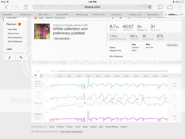
I'm afraid this might give my dreaded adversary T-mobile an advantage over me, but what the heck. I intend to use this type of stuff on my winter training program.
I don't own a real power meter, but I bought a gizmo which derives the power from my KKT. I only generate these numbers during basement workouts.
__________________
Momento mori, amor fati.
Momento mori, amor fati.
01-02-14 | 01:06 PM
#30
Senior Member
Joined: Jul 2008
Posts: 3,082
Likes: 24
From: Southern CaliFORNIA.
Bikes: KHS Alite 500, Trek 7.2 FX , Masi Partenza, Masi Fixed Special, Masi Cran Criterium
Garmin's are nice in that you don't need a separate cycling computer, they are water-resistant (they float too, but that's another story) and impact resistant. Compared to my phone, the GPS antenna on my Garmin is more sensitive which means that the track will be more accurate. And, if you have a Garmin with a barometric altimeter, your elevation and ascent will be more accurate.
I like that you can scroll through several display pages, and I have only two fields on each for easiest readability.
01-02-14 | 01:12 PM
#31


Version 7.0

Joined: Oct 2006
Posts: 13,844
Likes: 3,858
From: SoCa
Bikes: Road, Track, TT and Gravel
GPS v mobile phone accuracy - no contest.
01-02-14 | 01:12 PM
#32
www.ocrebels.com
Joined: Aug 2006
Posts: 6,186
Likes: 8
From: Los Angeles area
Bikes: Several bikes, Road, Mountain, Commute, etc.

Did you ride the Central Double Century in Litchfield, IL? That was my first double in '83 and my first (and only) triple in '85. Since you are in the St. Louis area, that would be my guess.
Bob Harting, who organized the CDC with the AYH every year now lives In the San Diego area and I see him every year on the Grand Tour Double out here (Malibu to Ojai and back, late June every year).
Rick / OCRR
01-02-14 | 01:26 PM
#34

Senior Member
Joined: Aug 2013
Posts: 806
Likes: 0
From: Alexander City, Alabama
What year was that written?
Never mind, I went and ready a little deeper. That's part of a sales pitch for a company selling GPS software and they install their own GPS receivers.
My phone doesn't use cell towers to pin point my GPS location or else Strava and Google maps would stop working in some of the places I cycle.
Never mind, I went and ready a little deeper. That's part of a sales pitch for a company selling GPS software and they install their own GPS receivers.
My phone doesn't use cell towers to pin point my GPS location or else Strava and Google maps would stop working in some of the places I cycle.
GPS v mobile phone accuracy - no contest.
Last edited by aubiecat; 01-02-14 at 01:41 PM.
") 01-02-14 | 01:32 PM
01-02-14 | 01:32 PM
#36

Senior Member
Joined: Feb 2013
Posts: 1,472
Likes: 11
From: Near St. Louis, Missouri
Bikes: Giant Defy Advanced, Breezer Doppler Team, Schwinn Twinn Tandem, Windsor Tourist, 1954 JC Higgens
Hi Jerry,
Did you ride the Central Double Century in Litchfield, IL? That was my first double in '83 and my first (and only) triple in '85. Since you are in the St. Louis area, that would be my guess.
Bob Harting, who organized the CDC with the AYH every year now lives In the San Diego area and I see him every year on the Grand Tour Double out here (Malibu to Ojai and back, late June every year).
Rick / OCRR
Doubles are challenging. I attempted 6 of them but only completed 4. Knee pain stopped me at 162 miles twice. My daughter did 355 miles at the MV24 when she was 18 YO.
01-02-14 | 01:40 PM
#37

It's MY mountain
Joined: Sep 2006
Posts: 10,173
Likes: 4,230
From: Mt.Diablo
Bikes: Klein, Merckx, Trek
GPS v mobile phone accuracy - no contest.
2. Written from perspective of cars, not bikes.
3. Discusses tracking only (my phone usually can tell which side of the street I'm on - can't imagine needing more accuracy than that); doesn't discuss elevation data at all, which was my point of contention concerning relative accuracy. The issue is whether altimeters are better than whatever the phone uses in Strava... I presume some kind of data table for coordinates.
Got anything else?
Last edited by DiabloScott; 01-02-14 at 01:47 PM.
01-02-14 | 01:48 PM
#38
Custom User Title
Joined: May 2013
Posts: 11,239
Likes: 35
From: SE MN
Bikes: Fuji Roubaix Pro & Quintana Roo Kilo
Good point, makes Garmin less unattractive.
1. A lot of talk with no experimental data.
2. Written from perspective of cars, not bikes.
3. Discusses tracking only; doesn't discuss elevation data at all, which was my point of contention concerning relative accuracy.
Got anything else?
1. A lot of talk with no experimental data.
2. Written from perspective of cars, not bikes.
3. Discusses tracking only; doesn't discuss elevation data at all, which was my point of contention concerning relative accuracy.
Got anything else?
01-02-14 | 01:51 PM
#39
Version 7.0
Joined: Oct 2006
Posts: 13,844
Likes: 3,858
From: SoCa
Bikes: Road, Track, TT and Gravel
Good point, makes Garmin less unattractive.
1. A lot of talk with no experimental data.
2. Written from perspective of cars, not bikes.
3. Discusses tracking only (my phone usually can tell which side of the street I'm on - can't imagine needing more accuracy than that); doesn't discuss elevation data at all, which was my point of contention concerning relative accuracy. The issue is whether altimeters are better than whatever the phone uses in Strava... I presume some kind of data table for coordinates.
Got anything else?
01-02-14 | 02:11 PM
#40
Senior Member
Joined: Jun 2007
Posts: 1,960
Likes: 1
From: Arizona
Bikes: Trek Domane 4.5, Trek 1500
I rode with Bob a few times a long time ago but I didn't do the Litchfield double. I did mine at the Mississippi Valley 24 Hour Challenge in New Baden plus a one-off double century out of Edwardsville. The MV24 was run by Mike Hahn also of AYH, or HI-GC or whatever they were calling it at that time.
Doubles are challenging. I attempted 6 of them but only completed 4. Knee pain stopped me at 162 miles twice. My daughter did 355 miles at the MV24 when she was 18 YO.
Doubles are challenging. I attempted 6 of them but only completed 4. Knee pain stopped me at 162 miles twice. My daughter did 355 miles at the MV24 when she was 18 YO.
01-02-14 | 02:26 PM
#41
It's MY mountain
Joined: Sep 2006
Posts: 10,173
Likes: 4,230
From: Mt.Diablo
Bikes: Klein, Merckx, Trek
https://strava.zendesk.com/entries/2...-Your-Activity
And here we have six people in my following group on the same climb - five different devices... not a bucket of spit worth of difference in the elevation data.

Official elevation at the Summit is 3,850 ft.
01-02-14 | 02:30 PM
#42
Custom User Title
Joined: May 2013
Posts: 11,239
Likes: 35
From: SE MN
Bikes: Fuji Roubaix Pro & Quintana Roo Kilo
I guess you'd have to define "wildly" - I haven't seen it. Here's Strava's discussion about it:
https://strava.zendesk.com/entries/2...-Your-Activity
And here we have six people in my following group on the same climb - five different devices... not a bucket of spit worth of difference in the elevation data.
Official elevation at the Summit is 3,850 ft.
https://strava.zendesk.com/entries/2...-Your-Activity
And here we have six people in my following group on the same climb - five different devices... not a bucket of spit worth of difference in the elevation data.
Official elevation at the Summit is 3,850 ft.
01-02-14 | 02:35 PM
#43
It's MY mountain
Joined: Sep 2006
Posts: 10,173
Likes: 4,230
From: Mt.Diablo
Bikes: Klein, Merckx, Trek
If the actual elevation values at any particular point agree, then it's the way your devices are summing up the totals, and not a measurement error. Strava talks about this in their "smoothing" function.
01-02-14 | 02:46 PM
#45
Custom User Title
Joined: May 2013
Posts: 11,239
Likes: 35
From: SE MN
Bikes: Fuji Roubaix Pro & Quintana Roo Kilo
That's certainly a lot. What were the actual values that are 1000 feet apart? And is this as reported on your Garmins or what Strava reported based on Garmin data?
If the actual elevation values at any particular point agree, then it's the way your devices are summing up the totals, and not a measurement error. Strava talks about this in their "smoothing" function.
If the actual elevation values at any particular point agree, then it's the way your devices are summing up the totals, and not a measurement error. Strava talks about this in their "smoothing" function.
01-02-14 | 03:23 PM
#46
Senior Member

Joined: Jul 2004
Posts: 13,358
Likes: 665
From: northern michigan
Bikes: '77 Colnago Super, '76 Fuji The Finest, '88 Cannondale Criterium, '86 Trek 760, '87 Miyata 712
I use Strava on my iphone. It has helped me greatly in my riding motivation. I know some of the guys I chase on these courses. I just want to be the best I can at 56yrs of age and have lots of fun doing it.
For ride data I have a small Garmin Geko 100 taped to the stem so I can know my speed, distance and elevation relative to the ride. Someday I'll upgrade to a real Garmin but I still have to take my phone because of obvious and less than obvious reasons.
For ride data I have a small Garmin Geko 100 taped to the stem so I can know my speed, distance and elevation relative to the ride. Someday I'll upgrade to a real Garmin but I still have to take my phone because of obvious and less than obvious reasons.
01-02-14 | 03:38 PM
#47
It's MY mountain
Joined: Sep 2006
Posts: 10,173
Likes: 4,230
From: Mt.Diablo
Bikes: Klein, Merckx, Trek
My only interest here is in education, not in bashing any component or technology or user - I hope that's clear.
1000 feet of difference on a 50 mile ride is big enough that you should notice some distinctions in the profile map.
If the elevations at particular points agree with each other then it's a software difference in summing up the totals.
And if the elevations don't match, then it's a measurement difference. This would be especially notable if you rode over any bridges over deep canyons or something like that... or if there were a severe weather change during the ride.
01-02-14 | 03:55 PM
#48
Custom User Title
Joined: May 2013
Posts: 11,239
Likes: 35
From: SE MN
Bikes: Fuji Roubaix Pro & Quintana Roo Kilo
My only interest here is in education, not in bashing any component or technology or user - I hope that's clear.
1000 feet of difference on a 50 mile ride is big enough that you should notice some distinctions in the profile map.
If the elevations at particular points agree with each other then it's a software difference in summing up the totals.
And if the elevations don't match, then it's a measurement difference. This would be especially notable if you rode over any bridges over deep canyons or something like that... or if there were a severe weather change during the ride.
1000 feet of difference on a 50 mile ride is big enough that you should notice some distinctions in the profile map.
If the elevations at particular points agree with each other then it's a software difference in summing up the totals.
And if the elevations don't match, then it's a measurement difference. This would be especially notable if you rode over any bridges over deep canyons or something like that... or if there were a severe weather change during the ride.
https://www.strava.com/activities/78985269
That would be the ride in particular (not sure if they're visible to the public or not). I guess he was using a garmin 705. The elevation maps look pretty close just eyeballing them.
01-02-14 | 04:05 PM
#49

Senior Member
Joined: Dec 2010
Posts: 8,951
Likes: 14
I suspect the GPS chip in Garmins is the same as in cell phones. My Galaxy S4 receives both GPS and Glonas and is better than my Garmins which don't receive Glonas. Some of the newer Garmins do, very likely because the chip was available having been designed for phones which are sold by the many millions.
01-02-14 | 04:13 PM
#50
It's MY mountain
Joined: Sep 2006
Posts: 10,173
Likes: 4,230
From: Mt.Diablo
Bikes: Klein, Merckx, Trek
https://www.strava.com/activities/78989742
https://www.strava.com/activities/78985269
That would be the ride in particular (not sure if they're visible to the public or not). I guess he was using a garmin 705. The elevation maps look pretty close just eyeballing them.
https://www.strava.com/activities/78985269
That would be the ride in particular (not sure if they're visible to the public or not). I guess he was using a garmin 705. The elevation maps look pretty close just eyeballing them.
It looks like there are some significant elevation differences (50 feet or so) for the first 15 miles, and then they match for the rest of the ride. Perhaps the barometer of the altimeter device was correcting itself in that period. You could download the GPX files and verify if you're interested (caution, those files are just lots of text and code)... wouldn't tell you which one is right, but might give some insight into why they're different.
BTW, the difference in air pressure between 1000 ft and 1010 feet is about 6/1000 of a psi - it's amazing how sensitive those altimeters can be, but it doesn't take much of a glitch to get a wonky result.