


Your Flatest Route - A Challenge
 06-26-19 | 10:15 AM
#1

Thread Starter
meh

Joined: Jul 2014
Posts: 4,742
Likes: 1,129
From: Hopkins, MN
Bikes: 23 Cutthroat, 21 CoMotion Java; 21 Bianchi Infinito; 15 Surly Pugsley; 11 Globe Daily; 09 Kona Dew Drop; 96 Mondonico
Your Flatest Route - A Challenge
I started this thread earlier this week - I might be a flatlander ... - it got me thinking about a challenge: What's your flatest route? I'm gonna say the route should to be roughly 40 miles or more and should be a loop or out-and-back (avoid doing short laps on repeat or a one-way route going down the side of a mountain).
For me, it's the Dakota Trail, it's 50+ miles (out and back) with a total of ~615 ft of climbing, or 12 ft/mile. The Dakota is a paved rail-trail running west of Minneapolis. https://www.strava.com/activities/315912883 I've liked it for constant effort rides, in addition to being flat, there are limited road crossings on the west end of this route.
For me, it's the Dakota Trail, it's 50+ miles (out and back) with a total of ~615 ft of climbing, or 12 ft/mile. The Dakota is a paved rail-trail running west of Minneapolis. https://www.strava.com/activities/315912883 I've liked it for constant effort rides, in addition to being flat, there are limited road crossings on the west end of this route.
 06-26-19 | 10:36 AM
#2


Non omnino gravis
Joined: Feb 2015
Posts: 8,552
Likes: 1,739
From: SoCal, USA!
Bikes: Nekobasu, Pandicorn, Lakitu

Doing any kind of lap route in Inland SoCal is gonna be 35ft/mi or more. That's just how it is. I live at ~1,300ft, and two subdivsions over (about 3 miles) it's 1,800ft. I can climb 3,000ft simply by riding 15 miles east.
Sooo... six laps around the old AFB now non-operational airport, bolstered by about twenty half-mile laps around Parking Lot C, just in front of the airport terminal. This is SoCal. 20ft/mi is as flat as it gets unless you go to the beach.
Even just riding beside the Santa Ana River for 20 miles picks up about 10ft/mi when going "downhill," and another 700ft or so on the return trip.
If it were one-way, I've found a route that can take me 70 miles from my house to the Pacific Ocean with barely 800ft of climbing. But the return trip is like 2,500ft.
I ride around that old AFB a lot. Closest thing we have to flat. And at that, the east end of the runway is 70ft higher than the west end.
__________________

06-26-19 | 10:47 AM
#3
Senior Member
Joined: Aug 2018
Posts: 472
Likes: 45
From: Mars Hotel
Bikes: Giant Talon 29 - Specialized Diverge E5 Comp
I don't have any numbers for you but it's flat here in western New York. Pedaling on the flats is not easy. If you're not spinning the pedals, you go no where. Zero downhills to take a deep breath. And no uphills to lose your breath. It's a steady grind. Start to finish.
06-26-19 | 10:54 AM
#4
Senior Member

Joined: Feb 2017
Posts: 1,931
Likes: 2,357
From: Hollister, CA (not the surf town)
Bikes: 2019 Specialized Roubaix Comp Di2, 2009 Roubaix, early 90's Giant Iguana
For me that would be riding to the coast and back. I'm at about 400ft elevation but there are rolling hills in between so going over and back on a 50-60 mile loop is about 800-900 ft. of climbing. I don't think I've ever done a ride of more than about 30 miles that had less than that.
06-26-19 | 11:00 AM
#5
Senior Member

Joined: Dec 2004
Posts: 12,560
Likes: 799
From: Middle of da Mitten
Bikes: Trek 7500, RANS V-Rex, Optima Baron, Velokraft NoCom, M-5 Carbon Highracer, Bacchetta Quattro, Catrike Speed
Southern Michigan averages 15-20 feet per mile. A 1500-foot century isn't unheard-of. The last time I did the Wolverine 200, it consisted of 40 laps of Bell Isle, with at most 5 ft/lap of climbing. Over 200 miles, that made for 200 feet total.
06-26-19 | 11:33 AM
#6

Sunshine
Joined: Aug 2014
Posts: 18,750
Likes: 10,313
From: Des Moines, IA
Bikes: '18 class built steel roadbike, '19 Fairlight Secan, '88 Schwinn Premis , Black Mountain Cycles Monstercross V4, '89 Novara Trionfo
The challenge is asking what other poster's flattest routes are?
Well consider your challenge completed because you succeeded! Good work!
All my rides upload to Strava at which time Strava decides to change the elevation gain to whatever they think it is. Guessing how much elevation Strava will remove from my GPS recorded ride is a game I now play after each ride.
Strava shows a 36mi ride I did a couple weeks ago as having 285' of climb which is under 8'/mile. My GPS shows it was 1332' of climb. Go figure.
There is a 44mi out and back thats all paved path on an old rail trail which is 44mi and 512' climb which ends up being 11.63' and I am pretty sure that is actually accurate. Its a 1% grade for half the ride up and 1% grade for half the ride down, going both ways. The only 'climb' is an approach to a road where the trail used to go in a small tunnel under the road, but the trail now goes up and over the road. Its a whopping 15' high, maybe.
 06-26-19 | 11:42 AM
#8
Senior Member
Joined: Jun 2013
Posts: 5,973
Likes: 1,397
From: SW Fl.
Bikes: 1999 DAHON Mariner, Day6 Semi Recumbent "FIREBALL", 1981 Custom Touring Paramount, 1983 Road Paramount, 2013 Giant Propel Advanced SL3, 2018 Specialized Red Roubaix Expert mech., 2002 Magna 7sp hybrid, 1976 Bassett Racing 45sp Cruiser
https://www.relive.cc/view/2451774101
BUT !!!! the following STRAVA replay is how the above was made with more miles and not much elevation change - 121.1 miles - 7hr 46min - 279ft - 15.6mph
https://www.relive.cc/view/2451714693
06-26-19 | 11:52 AM
#9

Mad bike riding scientist


Joined: Nov 2004
Posts: 29,202
Likes: 6,283
From: Denver, CO
Bikes: Some silver ones, a red one, a black and orange one, and a few titanium ones
The longest "flat" ride I can think of in Colorado is the 40 to 50 miles from Aspen to Glenwood Springs. It's right in the middle of the mountains but it only drops 462 feet over 41 miles (11feet/mile). Of course if you get off the trail to go anywhere else, things go south quickly.
Denver has the Platte River Trail which drops 700 feet in 37 miles (19 feet/mile) and the Cherry Creek Trail which is 700 feet in 27 miles (26 feet/mile). Again, any rides away from those trails get steep fast.
For true dead flatness, the Highline Canal Trail is a good bet. 50 miles, 530 feet or about 10 feet per mile.
__________________
Stuart Black
Dreamin' of Bemidji Down the Mississippi (in part)
Plan Epsilon Around Lake Michigan in the era of Covid
Gold Fever Three days of dirt in Colorado
Pokin' around the Poconos A cold ride around Lake Erie
Dinosaurs in Colorado A mountain bike guide to the Purgatory Canyon dinosaur trackway
Solo Without Pie. The search for pie in the Midwest.
Picking the Scablands. Washington and Oregon, 2005. Pie and spiders on the Columbia River!
06-26-19 | 11:59 AM
#10
Thread Starter
meh
Joined: Jul 2014
Posts: 4,742
Likes: 1,129
From: Hopkins, MN
Bikes: 23 Cutthroat, 21 CoMotion Java; 21 Bianchi Infinito; 15 Surly Pugsley; 11 Globe Daily; 09 Kona Dew Drop; 96 Mondonico
The challenge is asking what other poster's flattest routes are?
Well consider your challenge completed because you succeeded! Good work!
All my rides upload to Strava at which time Strava decides to change the elevation gain to whatever they think it is. Guessing how much elevation Strava will remove from my GPS recorded ride is a game I now play after each ride.
Strava shows a 36mi ride I did a couple weeks ago as having 285' of climb which is under 8'/mile. My GPS shows it was 1332' of climb. Go figure.
There is a 44mi out and back thats all paved path on an old rail trail which is 44mi and 512' climb which ends up being 11.63' and I am pretty sure that is actually accurate. Its a 1% grade for half the ride up and 1% grade for half the ride down, going both ways. The only 'climb' is an approach to a road where the trail used to go in a small tunnel under the road, but the trail now goes up and over the road. Its a whopping 15' high, maybe.
Well consider your challenge completed because you succeeded! Good work!
All my rides upload to Strava at which time Strava decides to change the elevation gain to whatever they think it is. Guessing how much elevation Strava will remove from my GPS recorded ride is a game I now play after each ride.
Strava shows a 36mi ride I did a couple weeks ago as having 285' of climb which is under 8'/mile. My GPS shows it was 1332' of climb. Go figure.
There is a 44mi out and back thats all paved path on an old rail trail which is 44mi and 512' climb which ends up being 11.63' and I am pretty sure that is actually accurate. Its a 1% grade for half the ride up and 1% grade for half the ride down, going both ways. The only 'climb' is an approach to a road where the trail used to go in a small tunnel under the road, but the trail now goes up and over the road. Its a whopping 15' high, maybe.
06-26-19 | 12:02 PM
#11
Senior Member
Joined: Sep 2008
Posts: 917
Likes: 84
From: NE Tennessee
Bikes: Giant TCR/Surly Karate Monkey/Foundry FireTower/Curtlo Tandem
Oh boy... We don't have anything like that here in the Appalachians. We do have a few mile stretch along the Holston River that perhaps is a 1% grade but that is it. All rollers.
06-26-19 | 12:06 PM
#12

Senior Member

Joined: Nov 2014
Posts: 27,576
Likes: 5,480
From: Eugene, Oregon, USA
Hmmm...
I'm at the southern end of the Willamette Valley, and there are a lot of flatish rides north of here. However, I tend to get a few hills or rollers getting out onto the valley.
Here is our local TT course:
https://www.strava.com/segments/12146625
24.8 miles, with about 30 miles for me to get there.
Most anywhere I go, I have a few hills on the ends. But, to put my daily hills into perspective, one simply has to look at a not so flat day.
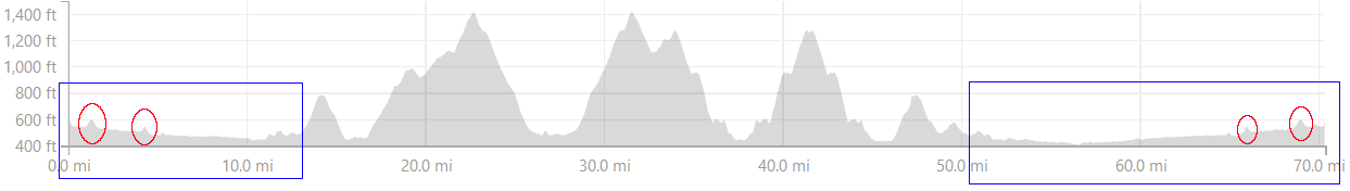
Circled in red are the two hills that I tend to hit on a daily basis. They can be real killers with heavy cargo loads. And, the blue boxes might be a typical day's ride.
I tend to have to hunt for the real hills.
I'm at the southern end of the Willamette Valley, and there are a lot of flatish rides north of here. However, I tend to get a few hills or rollers getting out onto the valley.
Here is our local TT course:
https://www.strava.com/segments/12146625
24.8 miles, with about 30 miles for me to get there.
Most anywhere I go, I have a few hills on the ends. But, to put my daily hills into perspective, one simply has to look at a not so flat day.
Circled in red are the two hills that I tend to hit on a daily basis. They can be real killers with heavy cargo loads. And, the blue boxes might be a typical day's ride.
I tend to have to hunt for the real hills.
06-26-19 | 12:30 PM
#15
Thread Starter
meh
Joined: Jul 2014
Posts: 4,742
Likes: 1,129
From: Hopkins, MN
Bikes: 23 Cutthroat, 21 CoMotion Java; 21 Bianchi Infinito; 15 Surly Pugsley; 11 Globe Daily; 09 Kona Dew Drop; 96 Mondonico
06-26-19 | 01:21 PM
#16

vespertine member
Joined: Jul 2013
Posts: 2,473
Likes: 223
From: Land of Angora, Turkey
Bikes: Yes
The only two flat routes I can think of nearby are the Great River Trail/Sparta-Elroy Trail, or riding to Houston, MN and hitting the Root River Trail. The former I avoid because it's crushed limestone (not my favorite, and very slow going) with washed out sections and portions that get closed down; the latter still requires probably 500' over 22 miles to get to the trail.
The La Crosse, WI - Houston, MN loop is my usual 'flat' ride, with ~44 miles and ~1100' elevation gain. The other flat ride is an out and back to Stoddard, WI, which is ~24 miles and ~400' elevation. My 'flat' century route (which I've done twice with first-time century riders) covers 105 miles through primarily SE Minnesota and northern IA; it comes out to ~3,500' over 105 miles. The only way to get flat in the Driftless is to hit the river valleys - but even then, there are some mild rollers.
The La Crosse, WI - Houston, MN loop is my usual 'flat' ride, with ~44 miles and ~1100' elevation gain. The other flat ride is an out and back to Stoddard, WI, which is ~24 miles and ~400' elevation. My 'flat' century route (which I've done twice with first-time century riders) covers 105 miles through primarily SE Minnesota and northern IA; it comes out to ~3,500' over 105 miles. The only way to get flat in the Driftless is to hit the river valleys - but even then, there are some mild rollers.
06-26-19 | 01:34 PM
#17
Senior Member
Joined: Aug 2014
Posts: 890
Likes: 10
From: Minnesnowta
Bikes: 2016 Trek Emonda SL, 2016 Framed Wolftrax
For me, it's the Dakota Trail, it's 50+ miles (out and back) with a total of ~615 ft of climbing, or 12 ft/mile. The Dakota is a paved rail-trail running west of Minneapolis. https://www.strava.com/activities/315912883 I've liked it for constant effort rides, in addition to being flat, there are limited road crossings on the west end of this route.
Doesn't hurt that it goes right past my neighborhood either.
06-26-19 | 02:30 PM
#18
Senior Member
Joined: Nov 2014
Posts: 27,576
Likes: 5,480
From: Eugene, Oregon, USA
I thought I'd try some scribbling on Strava.
https://www.strava.com/routes/19848785
79.21 miles, 584 feet, for an average of 7.37 feet per mile.
of course, the big issue would be the wind out there. There is often either a North or South wind, so one direction can be a hard push, and the other direction can be easy sailing.
https://www.strava.com/routes/19848785
79.21 miles, 584 feet, for an average of 7.37 feet per mile.
of course, the big issue would be the wind out there. There is often either a North or South wind, so one direction can be a hard push, and the other direction can be easy sailing.
06-26-19 | 02:58 PM
#19

Full Member
Joined: Apr 2017
Posts: 478
Likes: 130
From: Lafayette, Indiana
If I head due west away from the Wabash river I bet I could do a 40 mile loop at 400-600 ft. But wind farms are not my favorite view, so I usually head along the river which cuts 200 ft down, so going up and down that adds a lot...
06-26-19 | 03:23 PM
#21

Senior Member

Joined: Jan 2009
Posts: 6,667
Likes: 2,411
From: Colorado Springs, CO
Bikes: 2015 Charge Plug, 2007 Dahon Boardwalk, 1997 Specialized Rockhopper, 1984 Nishiki International, 2006 Felt F65, 1989 Dahon Getaway V
The longest "flat" ride I can think of in Colorado is the 40 to 50 miles from Aspen to Glenwood Springs. It's right in the middle of the mountains but it only drops 462 feet over 41 miles (11feet/mile). Of course if you get off the trail to go anywhere else, things go south quickly.
Denver has the Platte River Trail which drops 700 feet in 37 miles (19 feet/mile) and the Cherry Creek Trail which is 700 feet in 27 miles (26 feet/mile). Again, any rides away from those trails get steep fast.
For true dead flatness, the Highline Canal Trail is a good bet. 50 miles, 530 feet or about 10 feet per mile.
Denver has the Platte River Trail which drops 700 feet in 37 miles (19 feet/mile) and the Cherry Creek Trail which is 700 feet in 27 miles (26 feet/mile). Again, any rides away from those trails get steep fast.
For true dead flatness, the Highline Canal Trail is a good bet. 50 miles, 530 feet or about 10 feet per mile.
06-26-19 | 03:45 PM
#22
Senior Member
Joined: Jan 2011
Posts: 1,726
Likes: 169
From: Pinehurst, NC, US
Bikes: 2020 Trek Emonda SL6, 90's Vintage EL-OS Steel Bianchi with 2014 Campy Chorus Upgrade
I vacationed on Sanibel Island, Fl earlier this year. Not really good road biking country but on about any ride the high to low elevation change was maybe 10 feet. Dave
06-26-19 | 03:55 PM
#23
Senior Member
Joined: Nov 2014
Posts: 27,576
Likes: 5,480
From: Eugene, Oregon, USA

Utah also has great mountains, but the area west of Salt Lake is just FLAT!
06-26-19 | 03:56 PM
#24
Banned
Joined: Jun 2010
Posts: 43,586
Likes: 1,380
From: NW,Oregon Coast
Bikes: 8
Strong headwinds are a feature of the NL.. coming off the North Sea..
NW Pacific, here, less strong on shore winds through the estuary up river, and the grocery run, on the bike,
heavily laden. into that head wind.. and the rider, being over 70...
..
NW Pacific, here, less strong on shore winds through the estuary up river, and the grocery run, on the bike,
heavily laden. into that head wind.. and the rider, being over 70...
..
Last edited by fietsbob; 06-27-19 at 07:36 AM.
06-26-19 | 04:01 PM
#25
Mad bike riding scientist
Joined: Nov 2004
Posts: 29,202
Likes: 6,283
From: Denver, CO
Bikes: Some silver ones, a red one, a black and orange one, and a few titanium ones
The Rio Grande Trail (Aspen to Glenwood) is the best...and easiest 50 miles you can do in Colorado. It may not be steep but it is fast and completely downhill from Aspen to Glenwood. You can even put your bike on a bus that will take you from Glenwood to Aspen. They even have a special bike bus for the trip although the regular bus works as well.
__________________
Stuart Black
Dreamin' of Bemidji Down the Mississippi (in part)
Plan Epsilon Around Lake Michigan in the era of Covid
Gold Fever Three days of dirt in Colorado
Pokin' around the Poconos A cold ride around Lake Erie
Dinosaurs in Colorado A mountain bike guide to the Purgatory Canyon dinosaur trackway
Solo Without Pie. The search for pie in the Midwest.
Picking the Scablands. Washington and Oregon, 2005. Pie and spiders on the Columbia River!
Stuart Black
Dreamin' of Bemidji Down the Mississippi (in part)
Plan Epsilon Around Lake Michigan in the era of Covid
Gold Fever Three days of dirt in Colorado
Pokin' around the Poconos A cold ride around Lake Erie
Dinosaurs in Colorado A mountain bike guide to the Purgatory Canyon dinosaur trackway
Solo Without Pie. The search for pie in the Midwest.
Picking the Scablands. Washington and Oregon, 2005. Pie and spiders on the Columbia River!