


What is your favorite Bicycling Traii? , where is it? and why?
 07-01-13, 08:28 PM
#1
Senior Member
Thread Starter

Join Date: Jul 2013
Location: Spokane, WA
Posts: 66
Bikes: Fuji road bike and Mountain bike. Giant road bike and Mtn bike, Motobecane Crossbike and Mtn bike, Cycle Pro road bike.
Mentioned: 0 Post(s)
Tagged: 0 Thread(s)
Quoted: 0 Post(s)
Likes: 0
Liked 0 Times
in
0 Posts
What is your favorite Bicycling Trail? , where is it? and why?
One of my favorite biking trails is the Trolley Trail on the outskirts of Spokane, WA. It starts out like a smooth riding roller coaster with about a dozen humps. The trail surface starts out as fairly hard packed soil with pine needles to cushion your ride. The old trolley line with rails removed turns a bit rocky in places, going down hill with only a slight decline. About 1 1/2 miles in it opens up a mostly barren hillside and a 60 foot quick rocky drop (which I can handle now with my hydraulic brakes).
At this halfway point it rises and goes into a tree covered smooth trail again with occasional Deer, marmot and Moose sightings. Then it passes in a completely tree branch covered portion where several wooden boards were laid in what becomes mud in heavy rain, it is possible to walk your bike through this area that is only about 40 feet long. Then the trail has panoramic views of the City of Spokane in the distance and a highway down in the valley.
To this point a Mountain bike isn't really necessary except for the afore mentioned quick 60 foot drop. Now the trail turns downhill with medium sized rocks about 5-8 inches across and 3 - 7 inches high to avoid, again my hydraulic brakes make this part of the trail manageable again. Then the trail moves more parallel (horizontal) to the hill and is actually not part of the Official City/County owned Trolley trail. Just before the unofficial end of the Trail it goes straight downhill on a firm gravel surface to a low traffic city street which is only a few blocks from the large paved 'Rails to Trails' Spokane to Cheney Trail which is 15 miles long and almost all paved with water fountains, large paved parking lot, and restrooms at both the Spokane and Cheney ends of the Trail.
 07-01-13, 10:53 PM
#2

.
Join Date: May 2006
Location: Hillsboro, Oregon
Posts: 3,981
Bikes: Specialized Roubaix Comp, Soma ES
Mentioned: 0 Post(s)
Tagged: 0 Thread(s)
Quoted: 0 Post(s)
Likes: 0
Liked 0 Times
in
0 Posts
The Banks-Vernonia trail is my favorite. Rail-to-trail that is a slight incline for 20 miles to Vernonia. We usually stop there for lunch and enjoy a nice 20 mile coast all the way back to the car. Nice leisurely ride.
__________________
Demented internet tail wagging imbicile.
Demented internet tail wagging imbicile.
07-02-13, 12:27 AM
#3
Banned
I liked the ride from Napa to the swimming hole at the Conn lake reservoir , for its fresh chlorine free water.
but the city feared liability claims, so filled it in 30 years ago..
more recently I found the Bike /moped path from Ijmuiden, south along the NL coast
and the paths along side the shores of the Danube river , Germany, Austria, and into Hungary ..
but the city feared liability claims, so filled it in 30 years ago..
more recently I found the Bike /moped path from Ijmuiden, south along the NL coast
and the paths along side the shores of the Danube river , Germany, Austria, and into Hungary ..
Last edited by fietsbob; 03-06-14 at 11:34 AM.
07-02-13, 01:43 AM
#4

In Real Life

Join Date: Jan 2003
Location: Down under down under
Posts: 52,152
Bikes: Lots
Mentioned: 141 Post(s)
Tagged: 0 Thread(s)
Quoted: 3203 Post(s)
Liked 596 Times
in
329 Posts
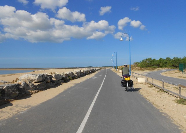
Velodyssey, the Atlantic cycling route
Whether you’re looking for a challenge or a leisurely cycle ride, Velodyssey has something for everyone.
Get on your bike and experience the wild beauty of a cycle route covering more than 1,200 kilometres from Brittany down the Atlantic coast to the border with Spain. The sea is never very far away as you discover the best each region has to offer along France’s longest waymarked cycle trail.
With our interactive maps and recommendations of the most suitable places for cyclists to stay, you can plan your very own Velodyssey in advance or just take off on the spur of the moment. You’ll find special offers, our pick of the best attractions to visit and reviews by those who’ve done the route. A voyage of discovery awaits you!
https://www.velodyssey.com/
We rode quite a bit of it, but would like to ride the whole thing. We loved the beaches ... kilometre after kilometre of gorgeous beaches.
Photos of when we were there last year ...
https://www.flickr.com/photos/machka-...7631877281412/

Whether you’re looking for a challenge or a leisurely cycle ride, Velodyssey has something for everyone.
Get on your bike and experience the wild beauty of a cycle route covering more than 1,200 kilometres from Brittany down the Atlantic coast to the border with Spain. The sea is never very far away as you discover the best each region has to offer along France’s longest waymarked cycle trail.
With our interactive maps and recommendations of the most suitable places for cyclists to stay, you can plan your very own Velodyssey in advance or just take off on the spur of the moment. You’ll find special offers, our pick of the best attractions to visit and reviews by those who’ve done the route. A voyage of discovery awaits you!
https://www.velodyssey.com/
We rode quite a bit of it, but would like to ride the whole thing.
We loved the beaches ... kilometre after kilometre of gorgeous beaches. Photos of when we were there last year ...
https://www.flickr.com/photos/machka-...7631877281412/
__________________
Rowan
My fave photo threads on BF
Century A Month Facebook Group
Machka's Website
Photo Gallery
Rowan
My fave photo threads on BF
Century A Month Facebook Group
Machka's Website
Photo Gallery
Last edited by Machka; 07-03-13 at 06:51 AM.
07-02-13, 01:47 AM
#5
In Real Life
Join Date: Jan 2003
Location: Down under down under
Posts: 52,152
Bikes: Lots
Mentioned: 141 Post(s)
Tagged: 0 Thread(s)
Quoted: 3203 Post(s)
Liked 596 Times
in
329 Posts
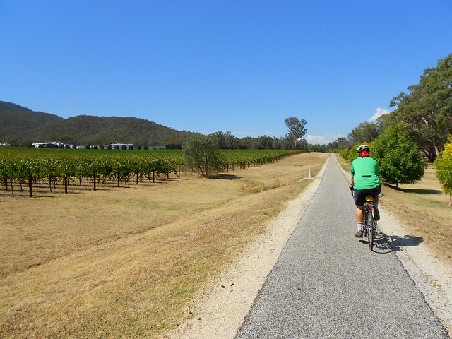
Murray to Mountains Rail Trail
The Murray to Mountains Rail Trail is the perfect way to discover the diverse landscape of North East Victoria - from natural bushland to abundant farmland, delightful hidden valleys and some of the Australia's most spectacular mountain ranges. Along the ride you'll savour some of Australia's finest gourmet produce, renowned wines, and handcrafted beer.
Over 100 kilometres of sealed off road trails provides you with the perfect link between the already popular tourist villages of Wangaratta, Beechworth, Rutherglen and Bright. More recently the off road sealed trail network has been extended from Wangaratta to Milawa and Bright to Wandiligong - for the perfect pedal to produce adventure.
So come and find out for yourself why this trail has been called Australia's Premier Rail Trail.
https://www.murraytomountains.com.au/
We've ridden different parts of this trail, and it is quite nice.
__________________
Rowan
My fave photo threads on BF
Century A Month Facebook Group
Machka's Website
Photo Gallery
Rowan
My fave photo threads on BF
Century A Month Facebook Group
Machka's Website
Photo Gallery
Last edited by Machka; 07-03-13 at 07:01 AM.
07-02-13, 07:35 AM
#6
working on my sandal tan

Join Date: Aug 2011
Location: CID
Posts: 22,629
Bikes: 1991 Bianchi Eros, 1964 Armstrong, 1988 Diamondback Ascent, 1988 Bianchi Premio, 1987 Bianchi Sport SX, 1980s Raleigh mixte (hers), All-City Space Horse (hers)
Mentioned: 98 Post(s)
Tagged: 0 Thread(s)
Quoted: 3871 Post(s)
Liked 2,568 Times
in
1,579 Posts
The Cedar Valley Nature Trail in my area is nice. Once you head out on the southern leg of it, there is a nice scenic stretch that is almost free of intersections with cars until the next town 9 miles away. The surface is well-kept, too.
07-02-13, 09:49 AM
#7
Full Member

the Fort Custer Red Loop is my favorite. Around 8 miles of challenging singletrack through forests with options available which avoid the most difficult parts.
07-02-13, 10:30 AM
#8
Senior Member

Join Date: Jan 2010
Posts: 1,811
Mentioned: 3 Post(s)
Tagged: 0 Thread(s)
Quoted: 184 Post(s)
Liked 353 Times
in
90 Posts
I really enjoy the Busse Woods Trail in Schaumburg, IL. I like getting there at sunrise. That way there are few people on the trail yet and I have a better chance of spotting a deer or two. Also can't go wrong with the grove of Elk.
From the TrailLink article about the trail....."The Busse Woods Trail system is located within Ned Brown Forest Preserve, a 3,700-acre property in the western suburbs of Chicago. There are 11.2 miles of paved trails for cyclists, equestrians and pedestrians. The main loop is nearly 8 miles, circling some lakes and meadows, while a couple of much shorter side loops will take you to the north and south end of the forest preserve."
From the TrailLink article about the trail....."The Busse Woods Trail system is located within Ned Brown Forest Preserve, a 3,700-acre property in the western suburbs of Chicago. There are 11.2 miles of paved trails for cyclists, equestrians and pedestrians. The main loop is nearly 8 miles, circling some lakes and meadows, while a couple of much shorter side loops will take you to the north and south end of the forest preserve."
07-02-13, 01:53 PM
#9
Senior Member
Thread Starter
Join Date: Jul 2013
Location: Spokane, WA
Posts: 66
Bikes: Fuji road bike and Mountain bike. Giant road bike and Mtn bike, Motobecane Crossbike and Mtn bike, Cycle Pro road bike.
Mentioned: 0 Post(s)
Tagged: 0 Thread(s)
Quoted: 0 Post(s)
Likes: 0
Liked 0 Times
in
0 Posts
Am always looking for a slight to moderate incline on long trails will have to do the Banks-Vernonia trail someday! Thanks
07-03-13, 04:09 AM
#10
Senior Member

Join Date: Apr 2007
Location: Northern VA
Posts: 2,654
Bikes: 2008 Trek Madone 5.5, 2009 Cervelo R3SL tdf edition, Cervelo R5 with Di2
Mentioned: 0 Post(s)
Tagged: 0 Thread(s)
Quoted: 2 Post(s)
Likes: 0
Liked 1 Time
in
1 Post
It's hard to be objective. There are some great trails here in DC and Northern VA, but I hate them. They're my main options during the week before, after, and going to work, so I just want to get OFF them when I get a chance.
07-03-13, 05:34 AM
#11
Senior Member
Join Date: Mar 2010
Location: new berlin wi
Posts: 232
Bikes: trek 720 multitrack hybred, 92 trek 2300, 2010 specialized roubaix, 2014 specialized roubaix
Mentioned: 0 Post(s)
Tagged: 0 Thread(s)
Quoted: 14 Post(s)
Likes: 0
Liked 17 Times
in
14 Posts
i like the glacial drumlin trail in wisconsin.
https://www.google.com/url?sa=t&rct=j...48705608,d.aWc
it's a converted rail bed from waukesha to almost madison.
from waukesha to dousman it's paved, 15 miles. the rest of the way it's crushed stone.
the nicest part about it is there are 3 rest stops with water and restrooms, waukesha the start, wales 7 miles, and dousman end of the pavement.
i live about 10 miles from it. it's a nice 50 mile ride for me from my house to dousman and back. the highway to the trail has a 3" section to the right of the fog line for a safe ride.
also if i feel energetic i can ride the glacial to the new berlin trail, https://www.google.com/url?sa=t&rct=j...FOutAuwjZInV2g to greenfield park.
there is a connection there to the hank arron trail, https://www.google.com/url?sa=t&rct=j...48705608,d.aWc, then ride to the milwaukee lakefront.
it's about a 120 mile round trip from my house to the lakefront, to dousman then back to my house. it's good or bad, depending on your point of view, there are almost no hills the entire trip.
07-03-13, 06:34 AM
#12
Senior member

Join Date: Oct 2004
Location: Oakville Ontario
Posts: 8,118
Mentioned: 25 Post(s)
Tagged: 0 Thread(s)
Quoted: 943 Post(s)
Liked 658 Times
in
371 Posts
I really enjoy the Busse Woods Trail in Schaumburg, IL. I like getting there at sunrise. That way there are few people on the trail yet and I have a better chance of spotting a deer or two. Also can't go wrong with the grove of Elk.
From the TrailLink article about the trail....."The Busse Woods Trail system is located within Ned Brown Forest Preserve, a 3,700-acre property in the western suburbs of Chicago. There are 11.2 miles of paved trails for cyclists, equestrians and pedestrians. The main loop is nearly 8 miles, circling some lakes and meadows, while a couple of much shorter side loops will take you to the north and south end of the forest preserve."
From the TrailLink article about the trail....."The Busse Woods Trail system is located within Ned Brown Forest Preserve, a 3,700-acre property in the western suburbs of Chicago. There are 11.2 miles of paved trails for cyclists, equestrians and pedestrians. The main loop is nearly 8 miles, circling some lakes and meadows, while a couple of much shorter side loops will take you to the north and south end of the forest preserve."
07-03-13, 07:31 AM
#14
Senior Member
Join Date: Jul 2008
Location: 25 miles northwest of Boston
Posts: 29,552
Bikes: Bottecchia Sprint, GT Timberline 29r, Marin Muirwoods 29er, Trek FX Alpha 7.0
Mentioned: 112 Post(s)
Tagged: 0 Thread(s)
Quoted: 5224 Post(s)
Liked 3,584 Times
in
2,344 Posts
some call it a bunny trail, it leads from our campground to Pilgrim Spring, where the Pilgrims had their first fresh water, I've tasted it and it's not bad, up the hill behind it are fresh wild blueberries. been taking the kids down this trail since they were in training wheels. it has degraded over the years and it's pretty bumpy. now it's just a tradition, but we also use it as a launching point to longer rides. it's a favorite trail because it is in one of our favorite places and because of our fun/funny memories.
https://goo.gl/maps/942qd
https://goo.gl/maps/942qd
07-03-13, 07:35 AM
#15
In Real Life
Join Date: Jan 2003
Location: Down under down under
Posts: 52,152
Bikes: Lots
Mentioned: 141 Post(s)
Tagged: 0 Thread(s)
Quoted: 3203 Post(s)
Liked 596 Times
in
329 Posts
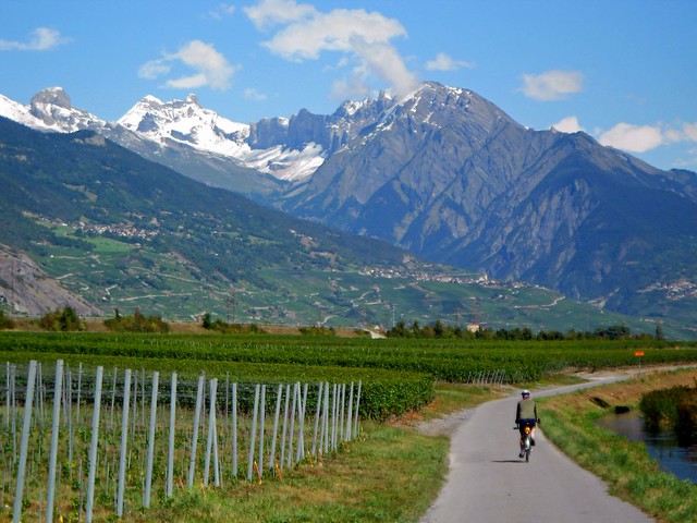
The Rhone Route
The Rhone Route runs through the magnificent mountain scenery of the Valais on charming, quiet paths along the Rhone. It leads along the famous palm-lined promenades of Lac L�man and the picturesque Lavaux vineyards and ends at cosmopolitan Gen�ve.
The Rhone Route runs through the magnificent mountain scenery of the Valais, embracing glistening Lac L�man.
After treeless Alpine pastures in Urserental, a perspiring climb up Furkapass followed by a heady downhill ride past the melting ice towers of the Rhone Glacier. Through Goms, the wide, sunny high-level valley of the young Rhone. Flower-filled fields and the aroma of resin accompany you almost to Brig, the main town of the upper Valais.
The main valley widens, sun heats the mountain flanks. Before the lively towns of Sierre und Sion, an unruly section of the Rhone widens out; the Pfynwald nature reserve on a huge detritus mound. The Dents du Midi dominates the mountain scenery in the lower Rhonetal. A world of orchards and vineyards.
Lac L�man, a small silver sea, surrounded by snow-capped peaks and the vineyard landscape of Lavaux and La C�te. Along the shores, the towns of Vevey, Montreux, the Vaud metropolis of Lausanne, then Nyon and cosmopolitan Gen�ve.
https://www.veloland.ch/en/routes/route-01.html
This is another lovely route ... this and the surrounding area. We based ourselves near Martigny, Switzerland and cycled parts of this route.
Photos ...
https://www.flickr.com/photos/machka-...7631598534353/
__________________
Rowan
My fave photo threads on BF
Century A Month Facebook Group
Machka's Website
Photo Gallery
Rowan
My fave photo threads on BF
Century A Month Facebook Group
Machka's Website
Photo Gallery
07-03-13, 07:58 AM
#17
Senior member
Join Date: Oct 2004
Location: Oakville Ontario
Posts: 8,118
Mentioned: 25 Post(s)
Tagged: 0 Thread(s)
Quoted: 943 Post(s)
Liked 658 Times
in
371 Posts
The Danube River trail ranks up there. Rode that from Passau Germany to Vienna in May of 2003. Highly recommend at that time of year. I've been told it's very busy in summer.
07-03-13, 07:59 AM
#18
Senior member
Join Date: Oct 2004
Location: Oakville Ontario
Posts: 8,118
Mentioned: 25 Post(s)
Tagged: 0 Thread(s)
Quoted: 943 Post(s)
Liked 658 Times
in
371 Posts
Murray to Mountains Rail Trail
The Murray to Mountains Rail Trail is the perfect way to discover the diverse landscape of North East Victoria - from natural bushland to abundant farmland, delightful hidden valleys and some of the Australia's most spectacular mountain ranges. Along the ride you'll savour some of Australia's finest gourmet produce, renowned wines, and handcrafted beer.
Over 100 kilometres of sealed off road trails provides you with the perfect link between the already popular tourist villages of Wangaratta, Beechworth, Rutherglen and Bright. More recently the off road sealed trail network has been extended from Wangaratta to Milawa and Bright to Wandiligong - for the perfect pedal to produce adventure.
So come and find out for yourself why this trail has been called Australia's Premier Rail Trail.
https://www.murraytomountains.com.au/
We've ridden different parts of this trail, and it is quite nice.
 07-03-13, 01:28 PM
#19
Member
Join Date: May 2012
Posts: 25
Mentioned: 0 Post(s)
Tagged: 0 Thread(s)
Quoted: 3 Post(s)
Likes: 0
Liked 0 Times
in
0 Posts
It's crowded and the oldest rail-to-trail in the U.S., but I've not had a finer ride than the 400 to Elroy-Sparta to LaCrosse River trails in Wisconsin!
 07-03-13, 03:20 PM
#21
Banned.

Join Date: Dec 2005
Location: Upland Ca
Posts: 19,895
Bikes: Lemond Chambery/Cannondale R-900/Trek 8000 MTB/Burley Duet tandem
Mentioned: 0 Post(s)
Tagged: 0 Thread(s)
Quoted: 0 Post(s)
Likes: 0
Liked 4 Times
in
3 Posts
SART- Santa Ana River Trail. 60 miles round trip to the coast. No car crossings and parks about 10 miles apart make for strategically placed rest stops.
Some shaded areas and some sunny, perfect mix.

On 100+ days we know 15-20 miles down the road the temps will drop 10-15 degrees once we near the coast. 102 in this area on Saturday's ride but later down the road at our rest stop, it was only 75.

Trail can be crowded with cyclists in the early mornings. But we start lat mornings (10:30 ?) so we miss most of the crowd and have LOTS of open space!

Lots of open space, lots of parks. I once forgot my water bottle and did 42 miles no problem. Few stops at the park.
 07-03-13, 03:42 PM
#22
Artificial Member

Join Date: Jan 2010
Location: Cyberspace
Posts: 7,158
Bikes: Retrospec Judd, Dahon Boardwalk, Specialized Langster
Mentioned: 31 Post(s)
Tagged: 0 Thread(s)
Quoted: 6766 Post(s)
Liked 5,479 Times
in
3,223 Posts
I like the Blue Ridge Parkway. It's a work out but beautiful. There are a couple of sections that locals use that at 'rush hour' times can be scary for the auto-phobic but generally the vehicular traffic is very considerate. I've ridden just about the whole thing except near Grandfather Mountain.
__________________
07-03-13, 08:49 PM
#23
In Real Life
Join Date: Jan 2003
Location: Down under down under
Posts: 52,152
Bikes: Lots
Mentioned: 141 Post(s)
Tagged: 0 Thread(s)
Quoted: 3203 Post(s)
Liked 596 Times
in
329 Posts
So in the absence of one favourite, I thought I'd list three that are decent.
__________________
Rowan
My fave photo threads on BF
Century A Month Facebook Group
Machka's Website
Photo Gallery
Rowan
My fave photo threads on BF
Century A Month Facebook Group
Machka's Website
Photo Gallery
07-04-13, 05:50 AM
#24
Senior Member
Join Date: Apr 2011
Location: Sheboygan Falls WI.
Posts: 277
Bikes: Trek , Fisher
Mentioned: 0 Post(s)
Tagged: 0 Thread(s)
Quoted: 0 Post(s)
Likes: 0
Liked 0 Times
in
0 Posts
07-04-13, 06:11 PM
#25
Senior Member
Thread Starter
Join Date: Jul 2013
Location: Spokane, WA
Posts: 66
Bikes: Fuji road bike and Mountain bike. Giant road bike and Mtn bike, Motobecane Crossbike and Mtn bike, Cycle Pro road bike.
Mentioned: 0 Post(s)
Tagged: 0 Thread(s)
Quoted: 0 Post(s)
Likes: 0
Liked 0 Times
in
0 Posts
SART- Santa Ana River Trail. 60 miles round trip to the coast. No car crossings and parks about 10 miles apart make for strategically placed rest stops.
That really sounds like a well thought out trail, all the amenities even a yellow dividing llane line. Will have to take a spin on my next SOCAL trip.
That really sounds like a well thought out trail, all the amenities even a yellow dividing llane line. Will have to take a spin on my next SOCAL trip.