


Teanaway River Road
 07-17-17 | 09:29 AM
#1
Thread Starter
Senior Member
Joined: Mar 2010
Posts: 23,208
Likes: 10,653
From: Seattle, WA
Teanaway River Road
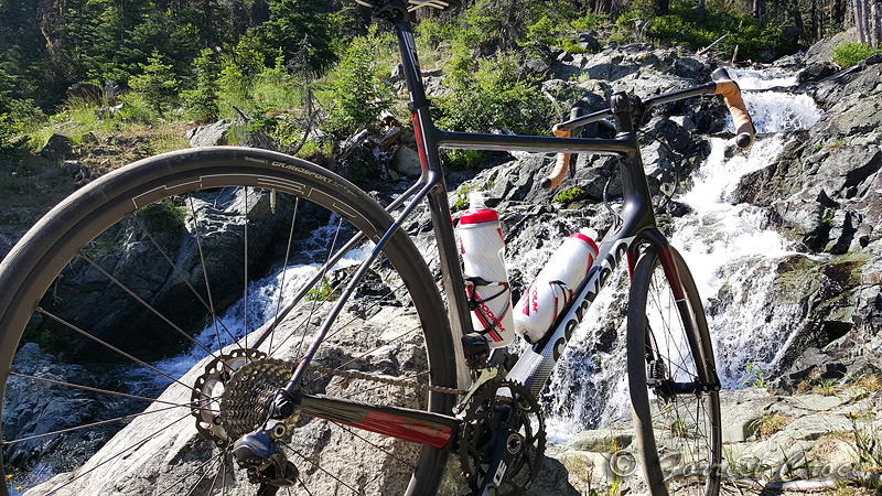
I don’t know why this took me so long, I’ve been wanting to ride this road for years. On Saturday I drove out to the Teanaway, parked at the river access where North and West Fork Roads meet, and rode up to the Esmeralda trailhead and back down. This was 32 miles total, 20 of them dirt and gravel, with about 2,000 feet of elevation change. The road is rough (washboarded), but not terribly steep. Scenery is incredible, and traffic is minimal. I was surprised to find the road closed (blocked by concrete barriers) about a mile from the end, near the Iron Peak trailhead. You can easily walk around with a bike.
I did this on 28 mm tires and felt beat up afterwards.
https://www.relive.cc/view/1085419979


I did this on 28 mm tires and felt beat up afterwards.
https://www.relive.cc/view/1085419979
 07-19-17 | 08:47 AM
#2

Squeaky Wheel

Joined: Nov 2008
Posts: 1,681
Likes: 116
From: Newcastle, WA
Nice SF.
No need to stop at the trailhead! The Esmeralda Basin trail is open to bikes and you can make a nice loop on on the Esmeralda and Boulder DeRoux trail with one section past Gallagher Head Lake on the "Jeep Road from Hell". But I think you would have been a little under-gunned on the machine you rode to the top
Here are some photos:
07-22-17 | 09:54 AM
#3
Thread Starter
Senior Member
Joined: Mar 2010
Posts: 23,208
Likes: 10,653
From: Seattle, WA
Thanks for sharing your photos [MENTION=148584]woodway[/MENTION]! Beautiful, as always, and what great scenery to ride through! Where is the third one?
I considered riding up there briefly, but I agreed with you about being on the wrong bike for the job. What did you do it on?
I've hiked a lot in that area, but you can cover so much more ground on a bike!
I considered riding up there briefly, but I agreed with you about being on the wrong bike for the job. What did you do it on?
I've hiked a lot in that area, but you can cover so much more ground on a bike!
07-22-17 | 04:50 PM
#4
Squeaky Wheel
Joined: Nov 2008
Posts: 1,681
Likes: 116
From: Newcastle, WA
The third one is at the high point of the Esmeralda Basin trail. It climbs up onto the shoulder of the Esmeralda Peaks at about 6000 feet. There is a little side scramble that gives an awesome view of Hawkins Mountain and the surrounding area which is where I took the photo from. Esmeralda Basin trail drops, quite steeply, off the backside into a series of pretty chunky switchbacks where it dumps you out onto the "Jeep Road from Hell" that you try to ride, but mainly push (although I know at least one person who has ridden it) up to Gallagher Head Lake. The descent from the lake is pure joy.
I rode it on a Turner RFX, full suspension mountain bike. It's a nice short backcountry mini-epic.
I rode it on a Turner RFX, full suspension mountain bike. It's a nice short backcountry mini-epic.
08-20-18 | 07:23 PM
#5
Newbie
Joined: Jul 2010
Posts: 1
Likes: 0
Thanks for this post! I rode the route (river access to Esmeralda trail head and back) last week and enjoyed it! Beautiful scenery indeed. There was a trace of smoke in the air due to forest fires. FYI There is construction activity 1/4 of a mile near the trail head which results in road closures. Don't get discouraged as to turn around. The closures last a few minutes only as crews maneuver their trucks.

Thread
Thread Starter
Forum
Replies
Last Post
Neil_B
Clydesdales/Athenas (200+ lb / 91+ kg)
3
07-30-11 10:13 AM
Pelotoner
Mountain - Plains
12
05-29-10 08:26 PM
jboyd
Clydesdales/Athenas (200+ lb / 91+ kg)
9
03-29-10 02:23 PM
