


Pacific Coast Route
 05-12-25 | 06:37 AM
#301
bicycle tourist

Joined: Dec 2007
Posts: 2,632
Likes: 470
From: Austin, Texas, USA
Bikes: Trek 520, Lightfoot Ranger, Trek 4500
Around here at least it seems to get used both for "bikes not allowed" and "this is a busy road so we're avoiding sending bikes here".
Where I know the roads, I'll occasionally be on short stretches of pink because while discouraged it often is a more direct way. For example, below is a Google Street View of a short section of road in Buda, TX that was marked pink. It is two lanes, no shoulder. However, bikes are allowed and I needed to travel 1/4 mile to the light at edge of the picture. I was on it the weekend before last because it was straightforward and direct. As the population grows in this area more roads that I've been familiar with traveling get marked as pink.
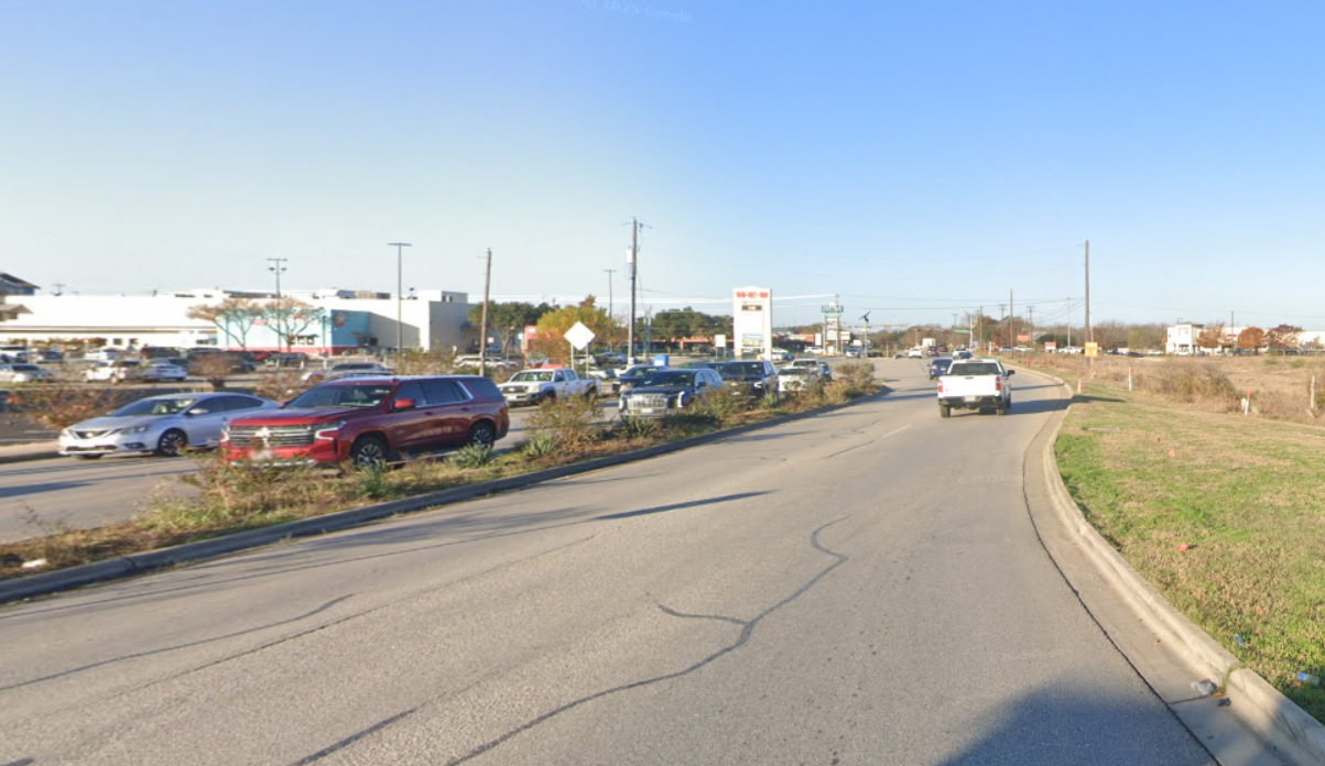
In areas where one is not familiar there might be no specific reason to ride the pink roads so that is fine. However, it can also be an opportunity to check out a bit more with street view or a heat map.
Where I know the roads, I'll occasionally be on short stretches of pink because while discouraged it often is a more direct way. For example, below is a Google Street View of a short section of road in Buda, TX that was marked pink. It is two lanes, no shoulder. However, bikes are allowed and I needed to travel 1/4 mile to the light at edge of the picture. I was on it the weekend before last because it was straightforward and direct. As the population grows in this area more roads that I've been familiar with traveling get marked as pink.
In areas where one is not familiar there might be no specific reason to ride the pink roads so that is fine. However, it can also be an opportunity to check out a bit more with street view or a heat map.
 05-18-25 | 05:45 PM
#302
Senior Member

Joined: Feb 2012
Posts: 844
Likes: 34
Maybe it's a spoiler, but you can see the route and road conditions with Google Maps and Street View. Hwy 101 for three miles south of Benbow Dr is the only route, and it's a winding two-lane road with a 1.5 foot shoulder. I still remember it forty years after the only time I did the PCBR in 1985. Bikes are also allowed on the pink section, so it might mean it's not the recommended route when the frontage road is available.
05-19-25 | 03:58 AM
#303
Senior Member


Joined: Aug 2010
Posts: 12,760
Likes: 2,114
From: Madison, WI
Bikes: 1961 Ideor, 1966 Perfekt 3 Speed AB Hub, 1994 Bridgestone MB-6, 2006 Airnimal Joey, 2009 Thorn Sherpa, 2013 Thorn Nomad MkII, 2015 VO Pass Hunter, 2017 Lynskey Backroad, 2017 Raleigh Gran Prix, 1980s Bianchi Mixte on a trainer. Others are now gone.
When I did Pacific Coast a decade ago, I felt safer on the busy road (below) than on the road in the second photo below because at least the busy road had a good shoulder. The not very busy road was winding and hilly, so traffic behind you might have their vision limited to less than 100 meters, and when you are in and out of shade while the driver behind you is also in and out of bright sun, that does not make for good vision either.

If the driver behind you is at 60 miles per hour, that is 88 feet per second so you do not have very many seconds to be seen.
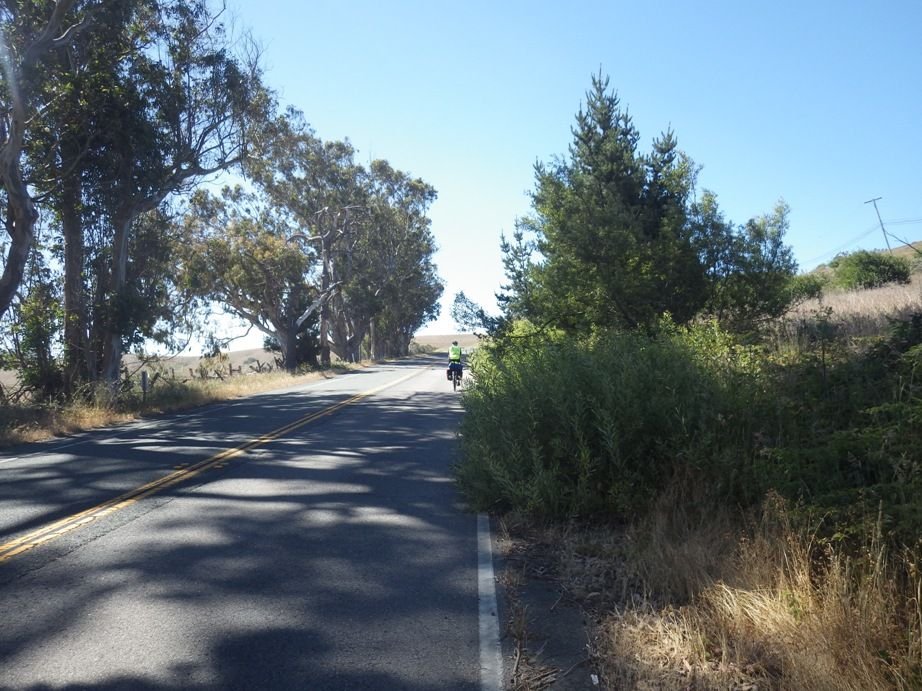
Some of the brush that was encroaching on the road was thorn bushes, you did not want to get your tires or skin too close.
If the driver behind you is at 60 miles per hour, that is 88 feet per second so you do not have very many seconds to be seen.
Some of the brush that was encroaching on the road was thorn bushes, you did not want to get your tires or skin too close.
05-25-25 | 11:21 AM
#304
Senior Member
Joined: Aug 2010
Posts: 12,760
Likes: 2,114
From: Madison, WI
Bikes: 1961 Ideor, 1966 Perfekt 3 Speed AB Hub, 1994 Bridgestone MB-6, 2006 Airnimal Joey, 2009 Thorn Sherpa, 2013 Thorn Nomad MkII, 2015 VO Pass Hunter, 2017 Lynskey Backroad, 2017 Raleigh Gran Prix, 1980s Bianchi Mixte on a trainer. Others are now gone.
FYI:
A portion of the Pacific Coast Highway finally reopens to the public after fires
May 25, 20258:10 AM ET
https://www.npr.org/2025/05/25/nx-s1...ic-after-fires
A portion of the Pacific Coast Highway finally reopens to the public after fires
May 25, 20258:10 AM ET
https://www.npr.org/2025/05/25/nx-s1...ic-after-fires
05-26-25 | 05:15 AM
#306
Senior Member
Joined: Aug 2010
Posts: 12,760
Likes: 2,114
From: Madison, WI
Bikes: 1961 Ideor, 1966 Perfekt 3 Speed AB Hub, 1994 Bridgestone MB-6, 2006 Airnimal Joey, 2009 Thorn Sherpa, 2013 Thorn Nomad MkII, 2015 VO Pass Hunter, 2017 Lynskey Backroad, 2017 Raleigh Gran Prix, 1980s Bianchi Mixte on a trainer. Others are now gone.
Thanks for posting.
05-26-25 | 05:30 AM
#307
Senior Member
Joined: Jul 2010
Posts: 13,921
Likes: 1,243
From: Montreal Canada
I personally am not keen on any sort of lock that requires a key, in the unlikely situation of losing it.
Sure, you can take a spare key, but I guess for what I use a bike lock on tour for, my coil lock is light and really will only stop an opportunistic theft, so I favour a no key approach for simplicity.
Sure, you can take a spare key, but I guess for what I use a bike lock on tour for, my coil lock is light and really will only stop an opportunistic theft, so I favour a no key approach for simplicity.
05-26-25 | 06:34 AM
#308
Newbie
Joined: Apr 2021
Posts: 70
Likes: 26
05-31-25 | 08:15 PM
#310
Senior Member

Joined: Sep 2012
Posts: 2,318
Likes: 2,535
From: Orange County, California
Bikes: Yes
FYI:
A portion of the Pacific Coast Highway finally reopens to the public after fires
May 25, 20258:10 AM ET
https://www.npr.org/2025/05/25/nx-s1...ic-after-fires
A portion of the Pacific Coast Highway finally reopens to the public after fires
May 25, 20258:10 AM ET
https://www.npr.org/2025/05/25/nx-s1...ic-after-fires
06-02-25 | 01:46 AM
#312
Senior Member
Joined: Feb 2012
Posts: 844
Likes: 34
[QUOTE=stevepusser;23533755]Unfortunately, that section of PCH has the last hike and bike campgrounds north of LA, and any alternate route involves a climb over the Conejo Grade into the San Fernando Valley, along US 101.
Which sections of PCH are so bad and narrow? They don't look so bad on Google Maps satellite view, though those images were taken post-firestorm, so some of the bike lanes are blocked with burned vehicles. The one time I did that in 2014, I don't recall it being so terrible, just with loads of speeding cars. I will of course defer to any first hand reports. The street view image from last March looks like there was more room for bikes and slower traffic, what with one lane being closed:Here's the alternate route up into the SFV:
Which sections of PCH are so bad and narrow? They don't look so bad on Google Maps satellite view, though those images were taken post-firestorm, so some of the bike lanes are blocked with burned vehicles. The one time I did that in 2014, I don't recall it being so terrible, just with loads of speeding cars. I will of course defer to any first hand reports. The street view image from last March looks like there was more room for bikes and slower traffic, what with one lane being closed:Here's the alternate route up into the SFV:
Last edited by stevepusser; 06-02-25 at 01:52 AM.
06-02-25 | 09:15 AM
#313
Senior Member
Joined: Sep 2012
Posts: 2,318
Likes: 2,535
From: Orange County, California
Bikes: Yes
Unfortunately, that section of PCH has the last hike and bike campgrounds north of LA, and any alternate route involves a climb over the Conejo Grade into the San Fernando Valley, along US 101.
Which sections of PCH are so bad and narrow? They don't look so bad on Google Maps satellite view, though those images were taken post-firestorm, so some of the bike lanes are blocked with burned vehicles. The one time I did that in 2014, I don't recall it being so terrible, just with loads of speeding cars. I will of course defer to any first hand reports. The street view image from last March looks like there was more room for bikes and slower traffic, what with one lane being closed: https://www.google.com/maps/@34.0368...oASAFQAw%3D%3D
Which sections of PCH are so bad and narrow? They don't look so bad on Google Maps satellite view, though those images were taken post-firestorm, so some of the bike lanes are blocked with burned vehicles. The one time I did that in 2014, I don't recall it being so terrible, just with loads of speeding cars. I will of course defer to any first hand reports. The street view image from last March looks like there was more room for bikes and slower traffic, what with one lane being closed: https://www.google.com/maps/@34.0368...oASAFQAw%3D%3D
Division of Traffic Operations - Road Information - California Highway Information
06-03-25 | 12:41 PM
#314
Senior Member
Joined: Feb 2012
Posts: 844
Likes: 34
Roughly its the section of PCH from the south end of Malibu towards the south down to the city border of Santa Monica. I'm going off the local news reports as Cal-Trans opened that section for cars last week but with reduced speed limits due to how narrow it is. I'm keeping an eye on it as I was hoping to do a short tour from San Luis Obispo down to the Orange County area in the fall (October/November timeframe). Cal-Trans does put out some brief road reports but they are just that ("brief") and kind of limited. Here's today's (June 2) report for the area, its the top entry as I post this:
Division of Traffic Operations - Road Information - California Highway Information
Division of Traffic Operations - Road Information - California Highway Information
06-03-25 | 01:00 PM
#315
Senior Member
Joined: Feb 2012
Posts: 844
Likes: 34
I tried ******, but it's having server issues for comments right now:

Go to BikeLA
r/BikeLA • 17 days ago
VictoryBetter5114
Go to BikeLA
r/BikeLA • 17 days ago
VictoryBetter5114
