


New Google Maps - - Yeech!
 11-21-24 | 12:45 AM
#1
Thread Starter
Hooked on Touring


Joined: Mar 2004
Posts: 3,029
Likes: 358
From: Wyoming
New Google Maps - - Yeech!
First there was the Edsel.
Then New Coke.
And now "New" Google Maps.
They've decided to convert everything to shades of blue, green, gray.
It's hard enough to see on a computer screen at home and impossible on the road.
Plus, back roads have been reduced to a near-invisible gray line.
The only way to see them is to zoom in to the last level, but then you can't see the bigger picture.
Nebraska has a well-designed state bike map where you can see low volume roads at a quick glance.
The colored routes only apply to state highways - green, blue, yellow, red.
(I think blue should be the least traffic a la William Least Heat Moon - but hey.)
Back roads are in gray - and show up against the white background. Solid - paved; dashed - unpaved.
https://dot.nebraska.gov/media/h1fn2...map-side-2.pdf
Opinions?
 11-21-24 | 02:58 AM
#2

Senior Member

Joined: Jan 2006
Posts: 3,655
Likes: 1,678
It is indeed terrible. They copied the road color scheme of Apple Maps. It was a purely a marketing decision to make it easier for Apple customers to try Google Maps. Aside from being a dirty shameless ripoff imitation, it also made the map nearly impossible to use visually. Disaster.
Did it change just recently for you? On my phone it changed in November 2023 (12 months ago).
I ditched Google Maps for bike touring and now use Mapy.cz.
Did it change just recently for you? On my phone it changed in November 2023 (12 months ago).
I ditched Google Maps for bike touring and now use Mapy.cz.

 11-21-24 | 06:58 AM
#4
Junior Member

Joined: Jun 2011
Posts: 183
Likes: 20
From: MASS
Bikes: Mostly low-income, poorly maintained broken ones
Consistent with the decline of Google search itself. Poor search results (overall superficiality over substance, and often providing what it thinks you should ask or want to know, versus what you asked), and now the option to provide more than 10 search results per page is gone, as if that usually suffices, and or everyone only uses smartphones. But now Google can show more ads. At least DuckDuckGo offers continuous scrolling of results.
11-21-24 | 11:30 PM
#5

Mad bike riding scientist

Joined: Nov 2004
Posts: 29,201
Likes: 6,283
From: Denver, CO
Bikes: Some silver ones, a red one, a black and orange one, and a few titanium ones
Huh? Here’s two screen captures from the Google map app on my phone. The first one is from 2015 and the next one is from this August. They look pretty much the same.
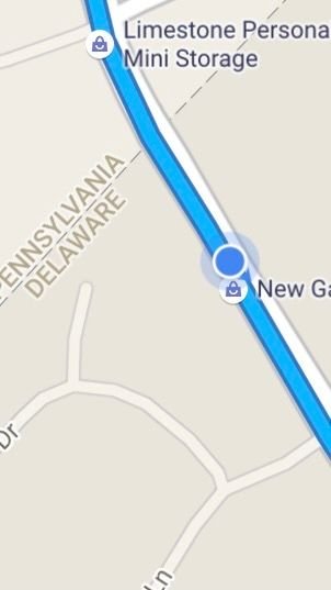
Even when I went to Google Maps instead of the app, I got this map. The Arsenal is about 6 miles across

Even when I went to Google Maps instead of the app, I got this map. The Arsenal is about 6 miles across
__________________
Stuart Black
Dreamin' of Bemidji Down the Mississippi (in part)
Plan Epsilon Around Lake Michigan in the era of Covid
Gold Fever Three days of dirt in Colorado
Pokin' around the Poconos A cold ride around Lake Erie
Dinosaurs in Colorado A mountain bike guide to the Purgatory Canyon dinosaur trackway
Solo Without Pie. The search for pie in the Midwest.
Picking the Scablands. Washington and Oregon, 2005. Pie and spiders on the Columbia River!
11-21-24 | 11:48 PM
#6

Sunshine
Joined: Aug 2014
Posts: 18,750
Likes: 10,313
From: Des Moines, IA
Bikes: '18 class built steel roadbike, '19 Fairlight Secan, '88 Schwinn Premis , Black Mountain Cycles Monstercross V4, '89 Novara Trionfo
I looked at my app after seeing this thread and had no idea what others are referencing because it looks the same as ever.
So I googled 'Google maps changed' and saw threads from message boards spanning various dates over the last 2 years...but nothing recent.
Sucks if some people can't easily see secondary roads.
So I googled 'Google maps changed' and saw threads from message boards spanning various dates over the last 2 years...but nothing recent.
Sucks if some people can't easily see secondary roads.
11-22-24 | 06:22 AM
#8

The space coyote lied.

Joined: Sep 2008
Posts: 48,884
Likes: 11,068
From: dusk 'til dawn.
Bikes: everywhere
11-22-24 | 09:42 AM
#9
Mad bike riding scientist
Joined: Nov 2004
Posts: 29,201
Likes: 6,283
From: Denver, CO
Bikes: Some silver ones, a red one, a black and orange one, and a few titanium ones

__________________
Stuart Black
Dreamin' of Bemidji Down the Mississippi (in part)
Plan Epsilon Around Lake Michigan in the era of Covid
Gold Fever Three days of dirt in Colorado
Pokin' around the Poconos A cold ride around Lake Erie
Dinosaurs in Colorado A mountain bike guide to the Purgatory Canyon dinosaur trackway
Solo Without Pie. The search for pie in the Midwest.
Picking the Scablands. Washington and Oregon, 2005. Pie and spiders on the Columbia River!
Stuart Black
Dreamin' of Bemidji Down the Mississippi (in part)
Plan Epsilon Around Lake Michigan in the era of Covid
Gold Fever Three days of dirt in Colorado
Pokin' around the Poconos A cold ride around Lake Erie
Dinosaurs in Colorado A mountain bike guide to the Purgatory Canyon dinosaur trackway
Solo Without Pie. The search for pie in the Midwest.
Picking the Scablands. Washington and Oregon, 2005. Pie and spiders on the Columbia River!
Last edited by cyccommute; 11-22-24 at 09:46 AM.
11-22-24 | 10:39 AM
#10
Senior Member
Joined: Sep 2015
Posts: 2,179
Likes: 202
From: QC Canada
Bikes: Custom built LHT & Troll
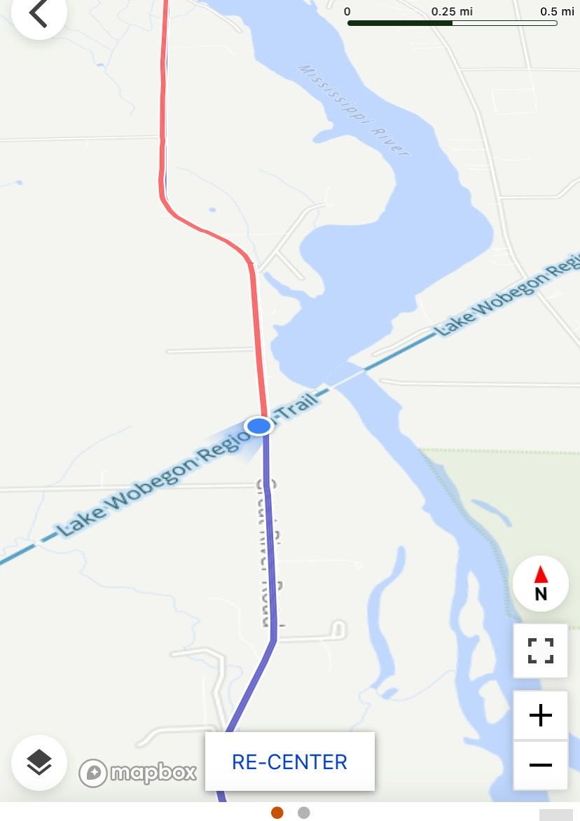
This is how your capture looks on my computer. Dark green lines are bike paths. They can be activated by clicking on the Layer Icon, bottom left (see capture below). FWIW, I've compared rendering in Locus and cycle.travel. Much less detail until you zoom in. Understandable due to the screen size.
[EDIT] More interesting than the color scheme is which (commercial) locations are highlighted. They are probably personalized... [/EDIT]


[EDIT] More interesting than the color scheme is which (commercial) locations are highlighted. They are probably personalized...
[/EDIT]Last edited by gauvins; 11-22-24 at 10:44 AM.
11-22-24 | 10:46 AM
#11
Mad bike riding scientist
Joined: Nov 2004
Posts: 29,201
Likes: 6,283
From: Denver, CO
Bikes: Some silver ones, a red one, a black and orange one, and a few titanium ones
This is how your capture looks on my computer. Dark green lines are bike paths. They can be activated by clicking on the Layer Icon, bottom left (see capture below). FWIW, I've compared rendering in Locus and cycle.travel. Much less detail until you zoom in. Understandable due to the screen size.
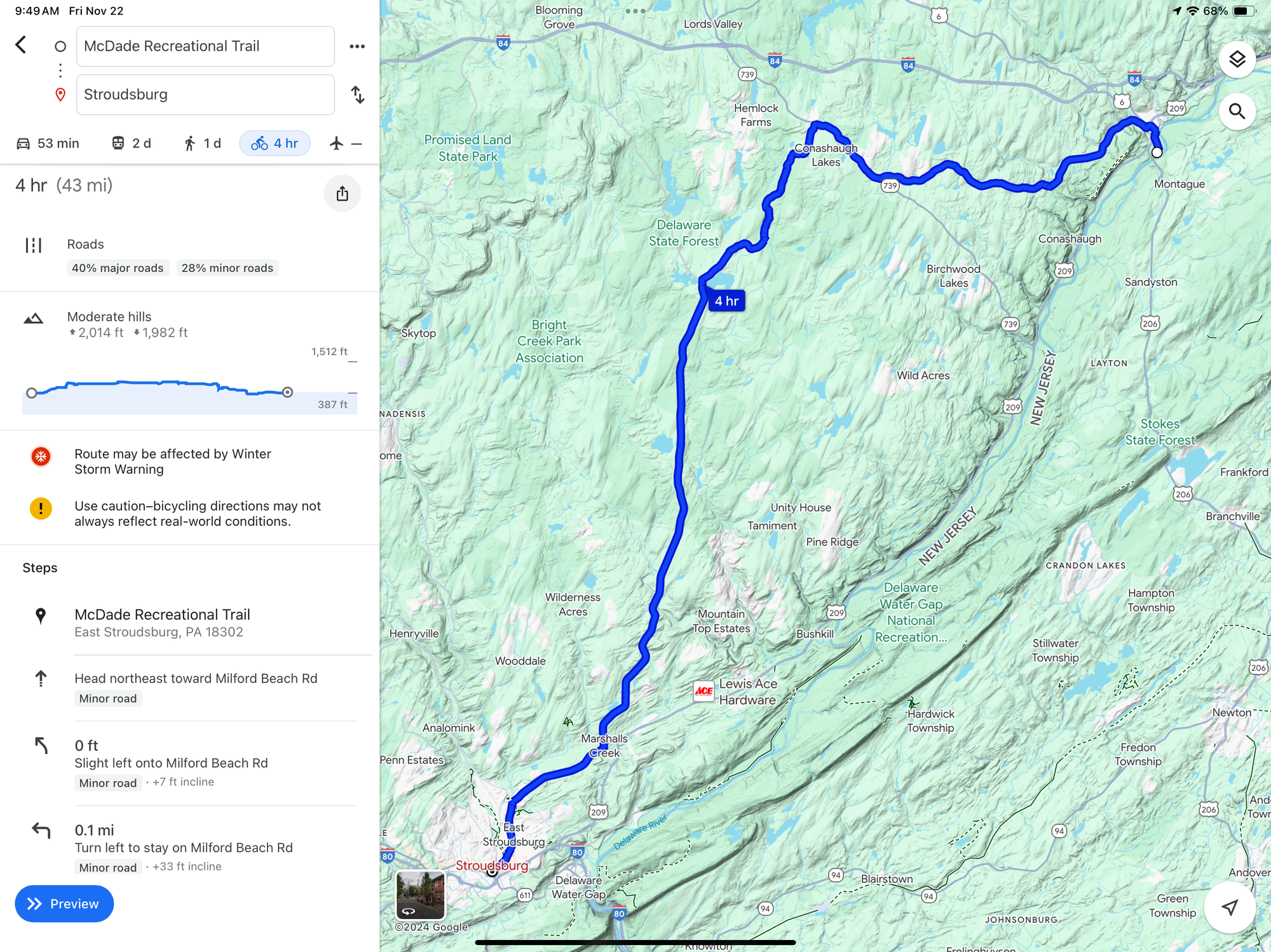
Here’s the profile from the route with nearly 3000 feet of climbing.
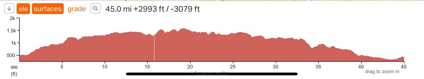
The same route on by car was only 34 miles with 1200 feet of climbing. I took the lower route and it was a very quiet road that was pleasant to ride.
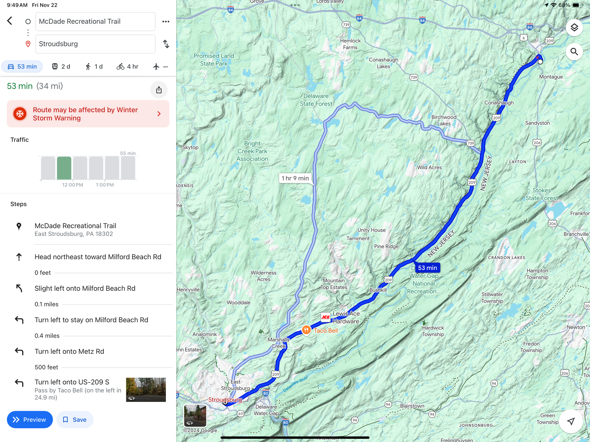
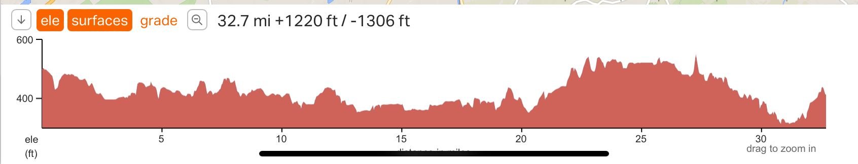
I found this problem constantly on my most recent trip. Google would send me off into the hills around the Mississippi with steep climbs while the flatter road was avoided.
__________________
Stuart Black
Dreamin' of Bemidji Down the Mississippi (in part)
Plan Epsilon Around Lake Michigan in the era of Covid
Gold Fever Three days of dirt in Colorado
Pokin' around the Poconos A cold ride around Lake Erie
Dinosaurs in Colorado A mountain bike guide to the Purgatory Canyon dinosaur trackway
Solo Without Pie. The search for pie in the Midwest.
Picking the Scablands. Washington and Oregon, 2005. Pie and spiders on the Columbia River!
Stuart Black
Dreamin' of Bemidji Down the Mississippi (in part)
Plan Epsilon Around Lake Michigan in the era of Covid
Gold Fever Three days of dirt in Colorado
Pokin' around the Poconos A cold ride around Lake Erie
Dinosaurs in Colorado A mountain bike guide to the Purgatory Canyon dinosaur trackway
Solo Without Pie. The search for pie in the Midwest.
Picking the Scablands. Washington and Oregon, 2005. Pie and spiders on the Columbia River!
Last edited by cyccommute; 11-22-24 at 11:03 AM.
11-22-24 | 11:41 AM
#12
Senior Member
Joined: Sep 2015
Posts: 2,179
Likes: 202
From: QC Canada
Bikes: Custom built LHT & Troll
Yeah... I do not use Google Maps to plan my routes. I wouldn't be surprised to learn that their algorithm puts a heavy premium on safety. I use cycle.travel as per suggestions made in another thread. Only good things to say about it. I've tried to figure the endpoints of your example. cycle.travel picked the more reasonable route.

 11-22-24 | 02:02 PM
#14
Mad bike riding scientist
Joined: Nov 2004
Posts: 29,201
Likes: 6,283
From: Denver, CO
Bikes: Some silver ones, a red one, a black and orange one, and a few titanium ones
Your picture is renders too small to see much of a difference, much less one that is �disgusting�.
__________________
Stuart Black
Dreamin' of Bemidji Down the Mississippi (in part)
Plan Epsilon Around Lake Michigan in the era of Covid
Gold Fever Three days of dirt in Colorado
Pokin' around the Poconos A cold ride around Lake Erie
Dinosaurs in Colorado A mountain bike guide to the Purgatory Canyon dinosaur trackway
Solo Without Pie. The search for pie in the Midwest.
Picking the Scablands. Washington and Oregon, 2005. Pie and spiders on the Columbia River!
Stuart Black
Dreamin' of Bemidji Down the Mississippi (in part)
Plan Epsilon Around Lake Michigan in the era of Covid
Gold Fever Three days of dirt in Colorado
Pokin' around the Poconos A cold ride around Lake Erie
Dinosaurs in Colorado A mountain bike guide to the Purgatory Canyon dinosaur trackway
Solo Without Pie. The search for pie in the Midwest.
Picking the Scablands. Washington and Oregon, 2005. Pie and spiders on the Columbia River!
11-22-24 | 02:07 PM
#15
Senior Member
Joined: Jan 2006
Posts: 3,655
Likes: 1,678
Bit blind, aren't you?
11-22-24 | 02:12 PM
#16
Senior Member
Joined: Jan 2006
Posts: 3,655
Likes: 1,678
Here you go.
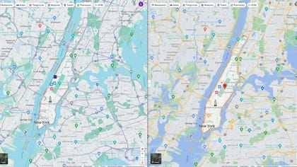
The biggest problem from a cycling perspective is that major and minor roads are now the same color. Makes it very difficult for bicyclists to choose quiet roads to ride on.
If you zoom in you'll also see that they took away the width on smaller lanes and made them simple lines. The changed color of woodland also makes green colored paths harder to see.
And yeah, the new colors are also more disgusting. Who wants to look at puke cyan and turquoise all day?
Last edited by Yan; 11-22-24 at 02:28 PM.
11-22-24 | 02:26 PM
#18
aka Timi
Joined: Feb 2009
Posts: 3,611
Likes: 326
From: Gothenburg, Sweden
Bikes: Bianchi Lupo & Bianchi Volpe Disc: touring. Bianchi Volpe: commuting
The old park and water colours were better, but the grey roads do have higher contrasts
Last edited by imi; 11-22-24 at 02:31 PM.
11-22-24 | 02:35 PM
#19
Senior Member
Joined: Jan 2006
Posts: 3,655
Likes: 1,678

 11-22-24 | 02:43 PM
#21
aka Timi
Joined: Feb 2009
Posts: 3,611
Likes: 326
From: Gothenburg, Sweden
Bikes: Bianchi Lupo & Bianchi Volpe Disc: touring. Bianchi Volpe: commuting
11-22-24 | 02:45 PM
#22
Senior Member
Joined: Jan 2006
Posts: 3,655
Likes: 1,678
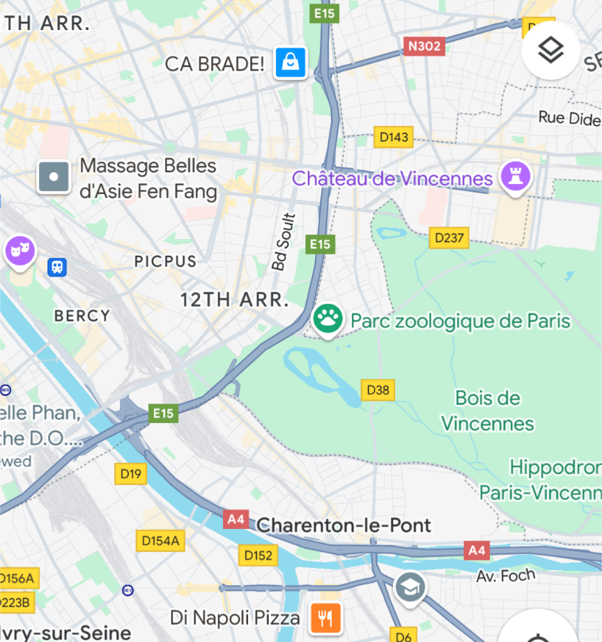
Old Google maps used to have three different colors for expressways, busy roads, and minor roads. They've reduced this.
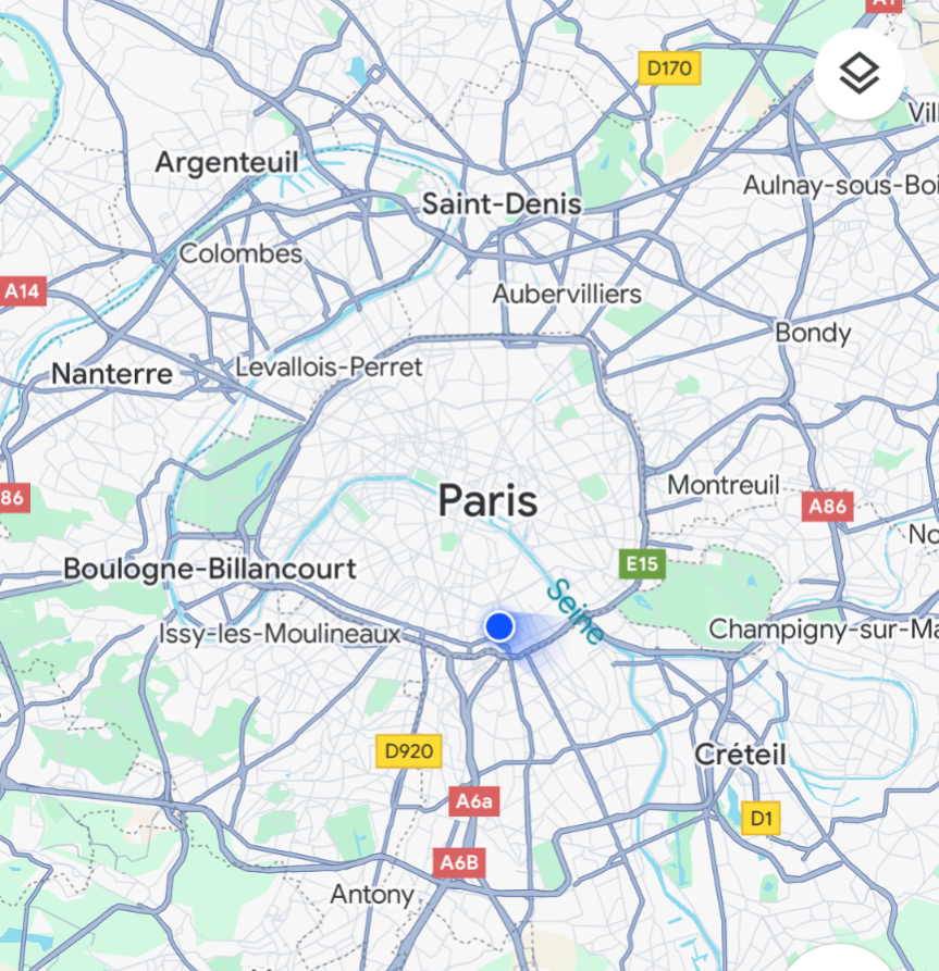
In the map below, A86 (red label) is a controlled access expressway. The other dark grey roads south of it (for example D909) are regular city roads with traffic lights. As you can see they have exactly the same color.
How does a bicyclist read this map? It's hard to tell where you can go and where you can't.
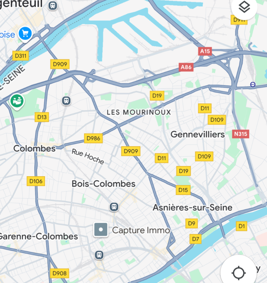
11-22-24 | 02:48 PM
#24
aka Timi
Joined: Feb 2009
Posts: 3,611
Likes: 326
From: Gothenburg, Sweden
Bikes: Bianchi Lupo & Bianchi Volpe Disc: touring. Bianchi Volpe: commuting
That said, riding through Paris has become a breeze thanks to all the new bike lanes
Last edited by imi; 11-22-24 at 02:54 PM.
11-22-24 | 02:52 PM
#25
Senior Member
Joined: Jan 2006
Posts: 3,655
Likes: 1,678
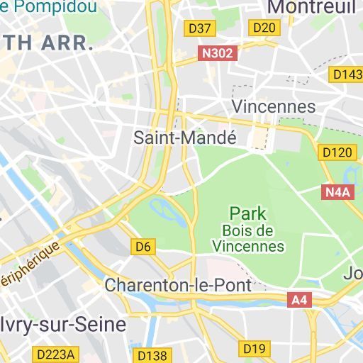
If you look at the old map in forum post #19 above, you can see that controlled access expressways were orange, busy city streets are yellow, and regular city streets are white.
That three tiered system was great in my opinion. Doesn't matter if they use an orange theme or any other colour theme, just make it obviously different.
The new one it's much harder to read.
That three tiered system was great in my opinion. Doesn't matter if they use an orange theme or any other colour theme, just make it obviously different.
The new one it's much harder to read.