


Denver - Gunnison, Colorado
 12-15-25 | 03:55 PM
#1
Thread Starter
Senior Member


Joined: Sep 2013
Posts: 1,671
Likes: 1,907
From: Spain
Denver - Gunnison, Colorado
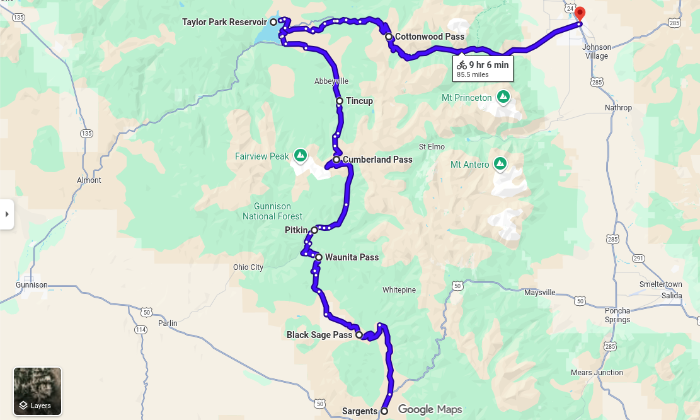
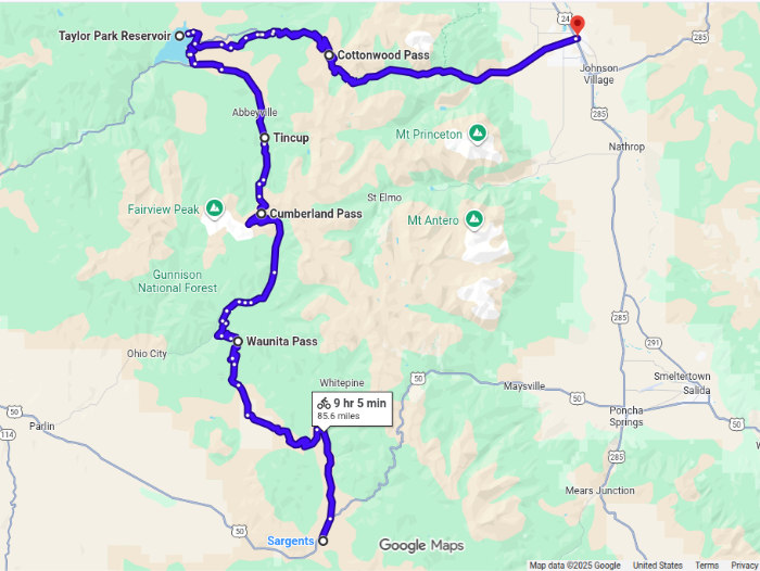
Denver - Gunnison
https://ridewithgps.com/routes/53332064
maybe maybe next summer we visit family of my wife in Denver.... maybe... still very early.
I planed that route, somebody here that knows these roads? what I was able to research in street view looks ok to me. but you never know.
Lions, bears, crocodiles.... ? roads with too much traffic?
After we would do this one: https://ridewithgps.com/routes/53259209
Anyway I am interested what people say who know these places of Colorado.
thanks.
__________________
https://stefanrohner.exposure.co
https://stefanrohner.exposure.co

 12-15-25 | 05:13 PM
#3
Senior Member


Joined: Jul 2007
Posts: 8,629
Likes: 3,542
From: South shore, L.I., NY
Bikes: Trek Emonda SL7, Cannondale Topstone, Miyata City Liner, Specialized Chisel, Specialized Epic Evo
Are you looking for something creative ?. It’s Rt285 to Buena Vista then west over Cottonwood pass to Gunnison. Not many alternatives unless you want a tour of a Colorado,
12-15-25 | 06:57 PM
#4
Senior Member
Joined: Feb 2010
Posts: 1,144
Likes: 266
From: NH
In 1983 I joined a long group road tour from Durango CO to Jasper AB. I left the group for two days near Monarch Pass to do this gravel side trip. Lots of climbing ... Cumberland Pass is 12,000' plus. Cottonwood Pass is now paved from Taylor Park to Buena Vista (red balloon). It was gravel in '83. I can't make RWGPS or Komoot work to map it. I'm sure you can!


Taylor Park Reservoir
Taylor Park Reservoir
Last edited by BobG; 12-28-25 at 07:31 AM. Reason: add locations to map
12-15-25 | 08:57 PM
#5

Mad bike riding scientist


Joined: Nov 2004
Posts: 29,202
Likes: 6,283
From: Denver, CO
Bikes: Some silver ones, a red one, a black and orange one, and a few titanium ones
Denver - Gunnison
https://ridewithgps.com/routes/53332064
maybe maybe next summer we visit family of my wife in Denver.... maybe... still very early.
I planed that route, somebody here that knows these roads? what I was able to research in street view looks ok to me. but you never know.
Lions, bears, crocodiles.... ? roads with too much traffic?
After we would do this one: https://ridewithgps.com/routes/53259209
Anyway I am interested what people say who know these places of Colorado.
thanks.
https://ridewithgps.com/routes/53332064
maybe maybe next summer we visit family of my wife in Denver.... maybe... still very early.
I planed that route, somebody here that knows these roads? what I was able to research in street view looks ok to me. but you never know.
Lions, bears, crocodiles.... ? roads with too much traffic?
After we would do this one: https://ridewithgps.com/routes/53259209
Anyway I am interested what people say who know these places of Colorado.
thanks.
Weston Pass is rideable but it is steep especially the last 4 miles. 10% grades are common. It�s a bit rocky on the north side (towards Leadville) but rideable.
You are routing over Tincup Pass which is steepish on the south side and very rocky on the north side. At St Elmo continue on up to Hancock and over to Cumberland Pass. This route takes you over Williams Pass which is fairly low but can be swappy at the top. You can also continue up to the east portal of the Alpine Tunnel and walk the roughly 1.5 miles over the top
If you do need to go to Breckenridge, here is a route from Littleton to Boulder and over Rollins Pass. Same distance but not quite as rugged.
__________________
Stuart Black
Dreamin' of Bemidji Down the Mississippi (in part)
Plan Epsilon Around Lake Michigan in the era of Covid
Gold Fever Three days of dirt in Colorado
Pokin' around the Poconos A cold ride around Lake Erie
Dinosaurs in Colorado A mountain bike guide to the Purgatory Canyon dinosaur trackway
Solo Without Pie. The search for pie in the Midwest.
Picking the Scablands. Washington and Oregon, 2005. Pie and spiders on the Columbia River!
12-16-25 | 04:00 AM
#6
Thread Starter
Senior Member
Joined: Sep 2013
Posts: 1,671
Likes: 1,907
From: Spain
In 1983 I joined a long group road tour from Durango CO to Jasper AB. I left the group for two days near Monarch Pass to do this gravel side trip. Lots of climbing ... Cumberland Pass is 12,000' plus. Cottonwood Pass is now paved from Taylor Park to Buena Vista (red balloon). It was gravel in'83. I can't make RWGPS or Komoot work to map it. I'm sure you can!
Taylor Park Reservoir
Taylor Park Reservoir
in another version I have the the road from Buena Vista over Cottonwood Pass and on to Almont - Gunnison included, but I thought its too much tarmac, also not sure about the motorised traffic there. Your version south looks interesting. But then from from Sargents on on the Highway 50? Looks like traffic. ... or not?
__________________
https://stefanrohner.exposure.co
https://stefanrohner.exposure.co
12-16-25 | 04:39 AM
#7
Thread Starter
Senior Member
Joined: Sep 2013
Posts: 1,671
Likes: 1,907
From: Spain
Your route is a bit circuitous. For example, you go over Georgia Pass to Breckenridge and then back to Como over Boreas Pass. Georgia Pass is very rugged on the west side while Boreas Pass is an old railroad grade. Do you have a need to go to Breckenridge? If not, there is no need for the (approximately) 50 mile detour to avoid riding about 5 miles on US285 from Jefferson to Como. If you want you can go across South Park from Tarryall Reservoir to Como via this route.
Weston Pass is rideable but it is steep especially the last 4 miles. 10% grades are common. It�s a bit rocky on the north side (towards Leadville) but rideable.
You are routing over Tincup Pass which is steepish on the south side and very rocky on the north side. At St Elmo continue on up to Hancock and over to Cumberland Pass. This route takes you over Williams Pass which is fairly low but can be swappy at the top. You can also continue up to the east portal of the Alpine Tunnel and walk the roughly 1.5 miles over the top
If you do need to go to Breckenridge, here is a route from Littleton to Boulder and over Rollins Pass. Same distance but not quite as rugged.
I don't have to go to Breckenridge at all ;) I included the two roads (see screenshot) since some street views looked very nice and also a friend sent beautiful pictures from there when he did the Tour Divide. I don't mind the detour if it's nice. I am open for any "better and nicer" suggestions, preferable off road better than tarmac, very rural tarmac is also cool.
Less rugged off road sounds great, thanks. So if you say ""you have to cycle this one... since it is nice"" I trust you ;) thats great. thanks very much for the suggestions, I am looking at them.
What would be your rural off and on road route to Gunnison. Would you go north in Denver and cycle your suggestion to Breckenridge or do something totally different.
Thanks!

__________________
https://stefanrohner.exposure.co
https://stefanrohner.exposure.co
12-16-25 | 04:52 AM
#8
Thread Starter
Senior Member
Joined: Sep 2013
Posts: 1,671
Likes: 1,907
From: Spain
P.S. what I like a bit more about my version going south is that one does not have to cross all the city Denver to Boulder. going south one is "faster" in nature.
I also have these two versions, which one is less rugged and/or nicer?
https://ridewithgps.com/routes/53360887
https://ridewithgps.com/routes/53369502
I also have these two versions, which one is less rugged and/or nicer?
https://ridewithgps.com/routes/53360887
https://ridewithgps.com/routes/53369502
__________________
https://stefanrohner.exposure.co
https://stefanrohner.exposure.co
Last edited by str; 12-16-25 at 05:33 AM.
12-16-25 | 07:32 AM
#9
Senior Member
Joined: Feb 2010
Posts: 1,144
Likes: 266
From: NH
That was 42 years ago. I'll defer to Stuart for current conditions.
12-16-25 | 08:21 AM
#10
Thread Starter
Senior Member
Joined: Sep 2013
Posts: 1,671
Likes: 1,907
From: Spain
You would not like US 50, Stefan. Traffic with a narrow intermittent shoulder, some long climbs with a truck lane. That said, it's part of the old ACA "Great Parks South" route. I rode it with the group from Montrose to Sargents where I turned off on the gravel side trip. The ACA route follows 50 all the way to Poncha Springs before turning north on US 285. That road is not much better. I did another longer gravel side trip in Montana & Idaho after parting with the group.
That was 42 years ago. I'll defer to Stuart for current conditions.
That was 42 years ago. I'll defer to Stuart for current conditions.
__________________
https://stefanrohner.exposure.co
https://stefanrohner.exposure.co
Last edited by str; 12-16-25 at 08:27 AM.
12-16-25 | 10:12 AM
#11
Mad bike riding scientist
Joined: Nov 2004
Posts: 29,202
Likes: 6,283
From: Denver, CO
Bikes: Some silver ones, a red one, a black and orange one, and a few titanium ones
thanks Stuart
I don't have to go to Breckenridge at all I included the two roads (see screenshot) since some street views looked very nice and also a friend sent beautiful pictures from there when he did the Tour Divide. I don't mind the detour if it's nice. I am open for any "better and nicer" suggestions, preferable off road better than tarmac, very rural tarmac is also cool.
Less rugged off road sounds great, thanks. So if you say ""you have to cycle this one... since it is nice"" I trust you thats great. thanks very much for the suggestions, I am looking at them.
What would be your rural off and on road route to Gunnison. Would you go north in Denver and cycle your suggestion to Breckenridge or do something totally different.
Thanks!
I don't have to go to Breckenridge at all
I included the two roads (see screenshot) since some street views looked very nice and also a friend sent beautiful pictures from there when he did the Tour Divide. I don't mind the detour if it's nice. I am open for any "better and nicer" suggestions, preferable off road better than tarmac, very rural tarmac is also cool.Less rugged off road sounds great, thanks. So if you say ""you have to cycle this one... since it is nice"" I trust you
thats great. thanks very much for the suggestions, I am looking at them.What would be your rural off and on road route to Gunnison. Would you go north in Denver and cycle your suggestion to Breckenridge or do something totally different.
Thanks!
Boreas Pass is a historic narrow gauge railroad bed. It�s part of the line that went to the Alpine Tunnel. It�s a relatively gentle grade and a fun ride from one side to the other or just from one side to the top. However, I wouldn�t go that far out of my way just to ride it.
Your route isn�t too far off of what I would do. I�d just make the changes I�ve suggested for simplicity. This route cuts across South Park without going on 285. You might have to divert a bit for camping in South Park as most of the valley is private land.
P.S. what I like a bit more about my version going south is that one does not have to cross all the city Denver to Boulder. going south one is "faster" in nature.
I also have these two versions, which one is less rugged and/or nicer?
https://ridewithgps.com/routes/53360887
https://ridewithgps.com/routes/53369502
I also have these two versions, which one is less rugged and/or nicer?
https://ridewithgps.com/routes/53360887
https://ridewithgps.com/routes/53369502
You wouldn�t start at Sargents. If you go over the Alpine Tunnel route, you�ll end up just above Pitkin. You can continue down hill to Parlin. From there you have about 10 miles of pavement on US50 with an option for some dirt roads just to the north of the highway. This route avoids going over Cumberland. Here�s that route.
__________________
Stuart Black
Dreamin' of Bemidji Down the Mississippi (in part)
Plan Epsilon Around Lake Michigan in the era of Covid
Gold Fever Three days of dirt in Colorado
Pokin' around the Poconos A cold ride around Lake Erie
Dinosaurs in Colorado A mountain bike guide to the Purgatory Canyon dinosaur trackway
Solo Without Pie. The search for pie in the Midwest.
Picking the Scablands. Washington and Oregon, 2005. Pie and spiders on the Columbia River!
12-16-25 | 10:52 AM
#12
Thread Starter
Senior Member
Joined: Sep 2013
Posts: 1,671
Likes: 1,907
From: Spain
Ha! Thanks Stuard, great, thank you. saved all your suggestions. will study them. looks good. thanks for including the camp spots.
and this one? ;) https://ridewithgps.com/routes/53524738
look how beautiful the Boreas Pass road. https://maps.app.goo.gl/5bLgRGpwMfgpmsYf6
some must see roads on the way to Gunnison?
I add the Sage and Saddle route.
and this one? ;) https://ridewithgps.com/routes/53524738
look how beautiful the Boreas Pass road. https://maps.app.goo.gl/5bLgRGpwMfgpmsYf6
some must see roads on the way to Gunnison?
I add the Sage and Saddle route.
__________________
https://stefanrohner.exposure.co
https://stefanrohner.exposure.co
Last edited by str; 12-16-25 at 10:56 AM.
12-16-25 | 12:23 PM
#13
Senior Member
Joined: Feb 2010
Posts: 1,144
Likes: 266
From: NH
Thanks for posting that video Stefan. The more rough & rubbley roads gave me flashbacks of the non-single track routes just north near Crested Butte. I've visited there twice with my MTB. Probably more than you'd tackle on your gravel bike.

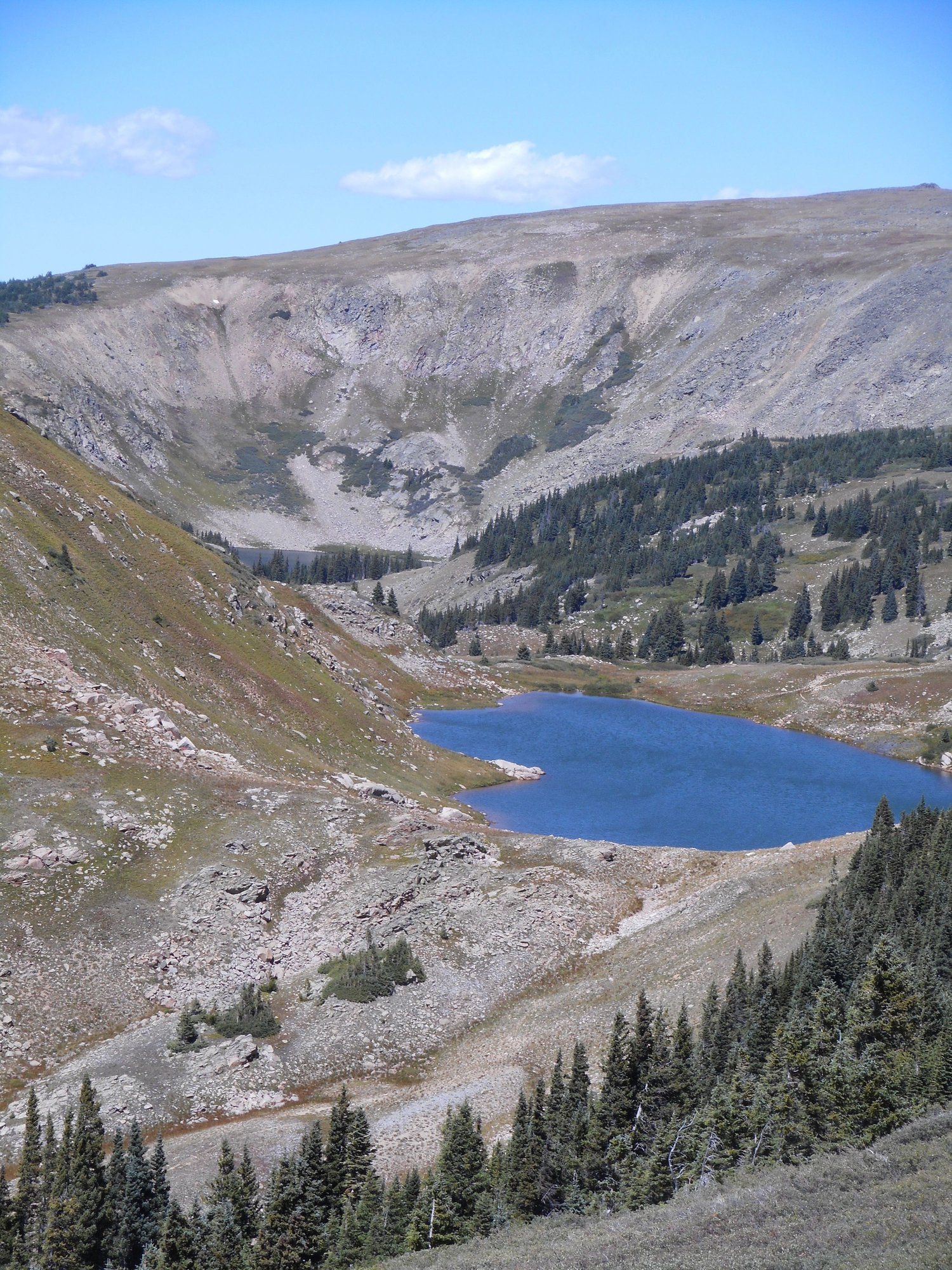
Pearl Pass CO
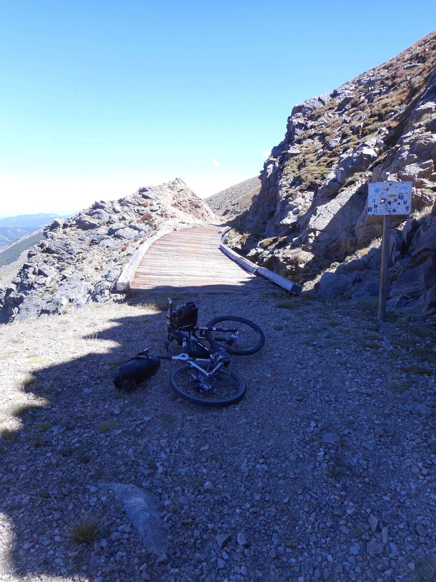
On the TransAm tours we'd always layover at Breckenridge. I remember doing a day ride up & back to the lovely Boreas Pass on my 700x32 road tires. As smooth as pavement! I was pushing the limits of my 35s in the photo at Cumberland Pass. Now that I'm older I'm up to 700x40s!
Coming from Spain I hope you have time to acclimate to the elevation.
Pearl Pass CO
On the TransAm tours we'd always layover at Breckenridge. I remember doing a day ride up & back to the lovely Boreas Pass on my 700x32 road tires. As smooth as pavement! I was pushing the limits of my 35s in the photo at Cumberland Pass. Now that I'm older I'm up to 700x40s!
Coming from Spain I hope you have time to acclimate to the elevation.
Last edited by BobG; 12-16-25 at 02:35 PM.
 12-16-25 | 04:19 PM
#16
Mad bike riding scientist
Joined: Nov 2004
Posts: 29,202
Likes: 6,283
From: Denver, CO
Bikes: Some silver ones, a red one, a black and orange one, and a few titanium ones
Ha! Thanks Stuard, great, thank you. saved all your suggestions. will study them. looks good. thanks for including the camp spots.
and this one? https://ridewithgps.com/routes/53524738
look how beautiful the Boreas Pass road. https://maps.app.goo.gl/5bLgRGpwMfgpmsYf6
and this one?
https://ridewithgps.com/routes/53524738look how beautiful the Boreas Pass road. https://maps.app.goo.gl/5bLgRGpwMfgpmsYf6
I can�t get to the map. It�s marked private.
some must see roads on the way to Gunnison?
__________________
Stuart Black
Dreamin' of Bemidji Down the Mississippi (in part)
Plan Epsilon Around Lake Michigan in the era of Covid
Gold Fever Three days of dirt in Colorado
Pokin' around the Poconos A cold ride around Lake Erie
Dinosaurs in Colorado A mountain bike guide to the Purgatory Canyon dinosaur trackway
Solo Without Pie. The search for pie in the Midwest.
Picking the Scablands. Washington and Oregon, 2005. Pie and spiders on the Columbia River!
12-16-25 | 04:36 PM
#17
Thread Starter
Senior Member
Joined: Sep 2013
Posts: 1,671
Likes: 1,907
From: Spain
made it public... thanks. tomorrow more ,,,
started to read this: https://www.crazyguyonabike.com/doc/?doc_id=8168
started to read this: https://www.crazyguyonabike.com/doc/?doc_id=8168
__________________
https://stefanrohner.exposure.co
https://stefanrohner.exposure.co
12-17-25 | 02:53 AM
#18
Thread Starter
Senior Member
Joined: Sep 2013
Posts: 1,671
Likes: 1,907
From: Spain
"""Boreas is, in fact lovely. But so are any number of other passes along the way."""
you know what I also love about rout planing and riding after. First you see something beautiful in street view and later in real life ... the beautiful memory effect.
for example, street view and reality:
https://maps.app.goo.gl/Ha5hF7ihYBir3PGZ6

you know what I also love about rout planing and riding after. First you see something beautiful in street view and later in real life ... the beautiful memory effect.
for example, street view and reality:
https://maps.app.goo.gl/Ha5hF7ihYBir3PGZ6
__________________
https://stefanrohner.exposure.co
https://stefanrohner.exposure.co
Last edited by str; 12-17-25 at 10:47 AM.
12-17-25 | 06:10 AM
#19
Senior Member
Joined: Feb 2010
Posts: 1,144
Likes: 266
From: NH
Stefan- Yesterday I cycled from Sargents to Gunnison courtesy of Street View to refresh my memory. The westward Gunnison direction is not as congested as I had recalled & only 35 miles. Monarch Pass & the truck climbing lanes are east of Sargents. Take a look at Street View. It's open, pleasant, uncluttered scenery the whole way albeit with some traffic. 2022 images show a good shoulder & recent pavement with a rumble strip to avoid. In some locations the shoulder narrows. 50 may be OK just to get you there from any gravel endpoint.
Last edited by BobG; 12-17-25 at 11:01 AM. Reason: typo
12-17-25 | 06:41 PM
#20
Mad bike riding scientist
Joined: Nov 2004
Posts: 29,202
Likes: 6,283
From: Denver, CO
Bikes: Some silver ones, a red one, a black and orange one, and a few titanium ones
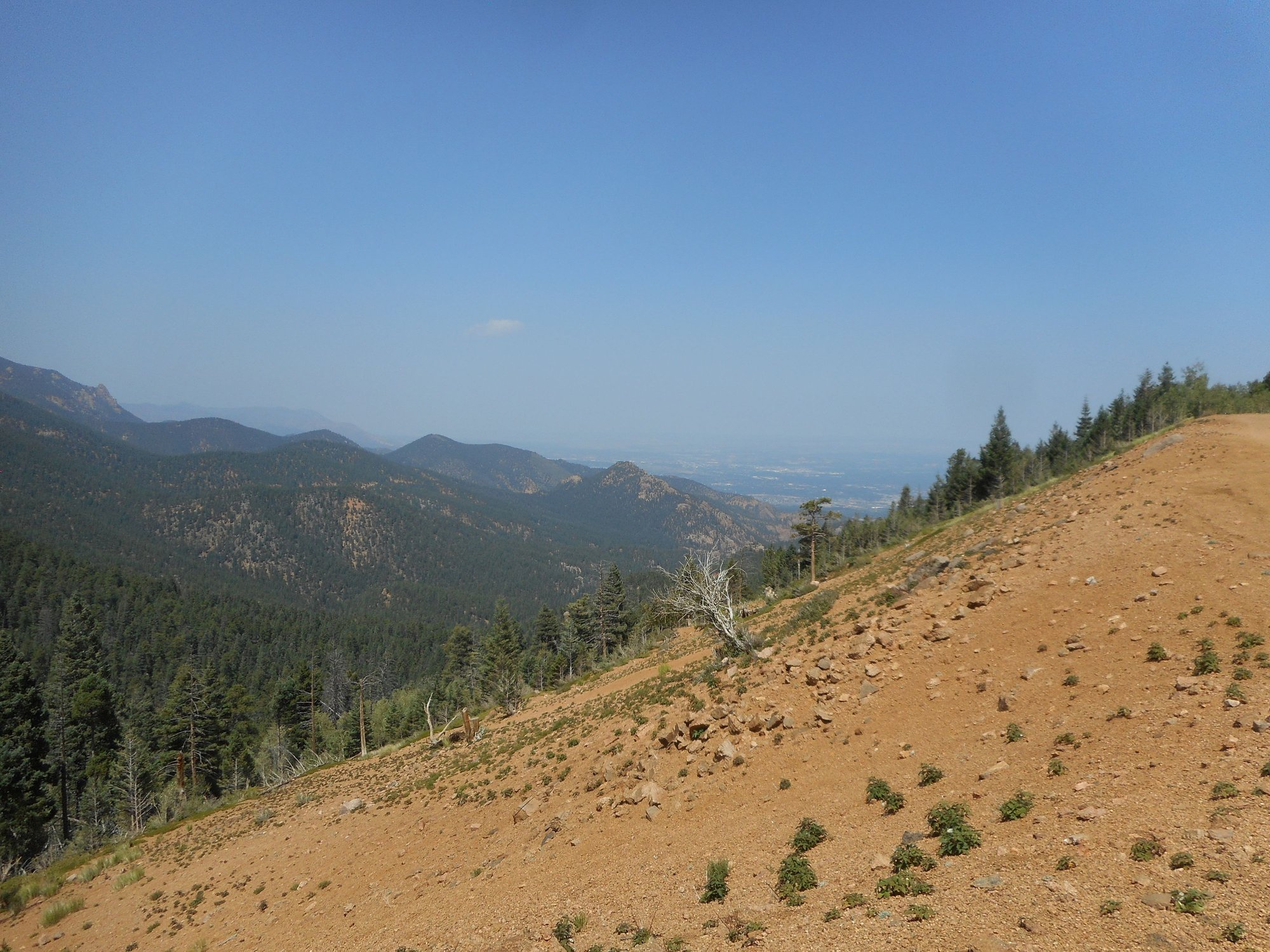
Here are some pictures from Rollins Pass for you Stefan (that’s the route through Boulder).
The view down valley from Needles Eye Tunnel

Jenny Lake with Yankee Doodle Lake in the background. Edit: That’s not Jenny Lake. It’s Pumphouse Lake on the west side. The lake in the distance is Corona Lake.
Needles Eye. It is blocked due to a cave-in. You could probably bypass it by taking the trail to the right or you can go up a steep trail a bit further south over the top.

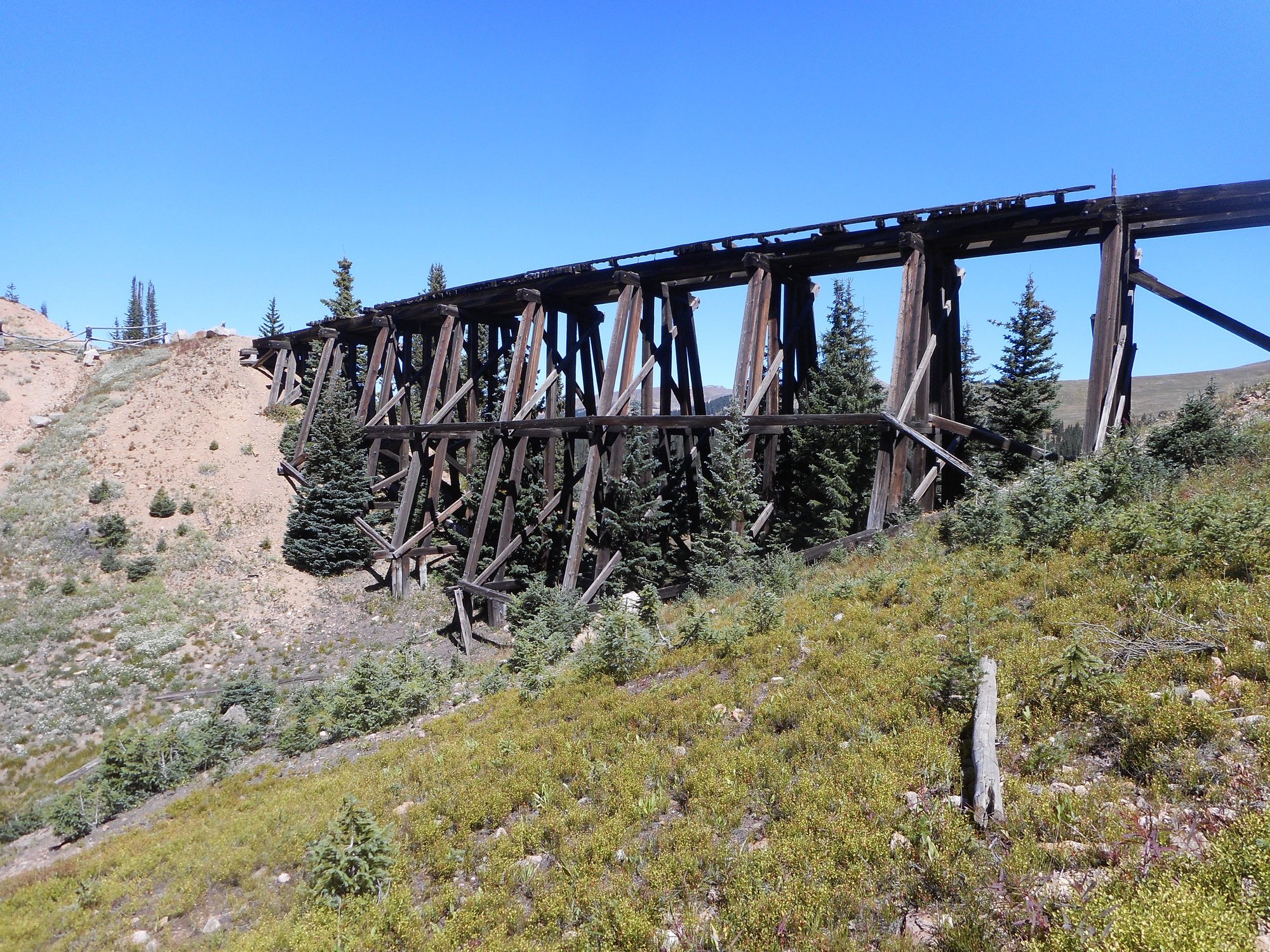
A large part of the draw to this route is the Devil’s Slide trestles (2 of them).
While it looks like the trestle is hanging in thin (very thin at around 10,000 feet)…
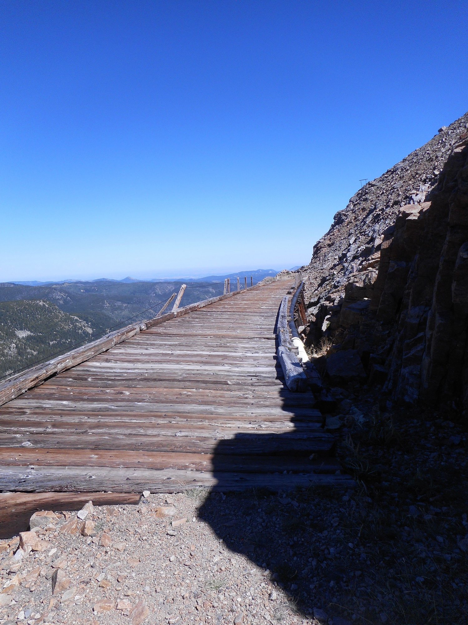
…it really is! The slide drops about 1300 feet to South Boulder Creek.
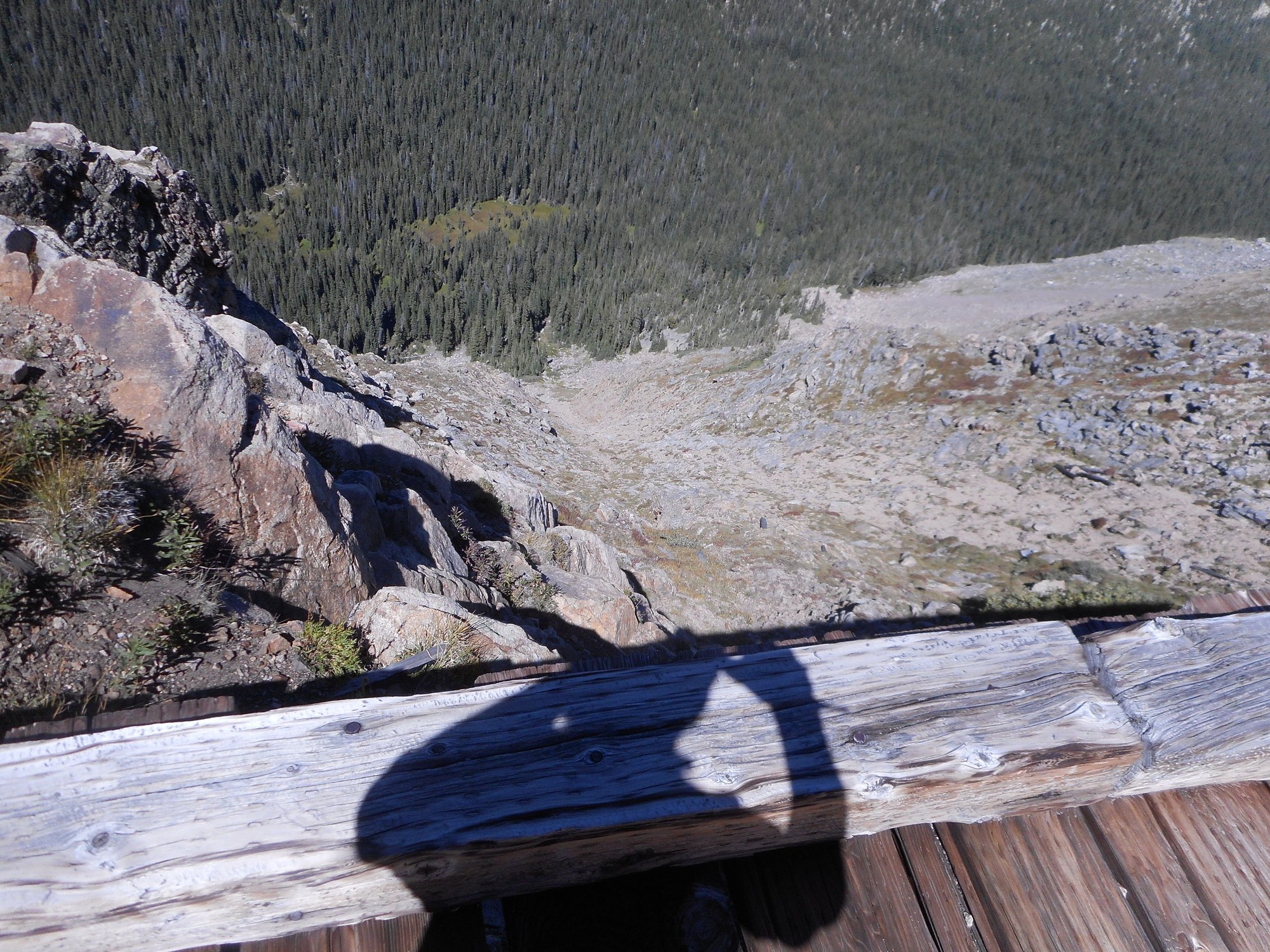
I never realized how exposed it was until I was fishing on the other side of the canyon and got this picture of the trestle clinging to the side of the mountain.
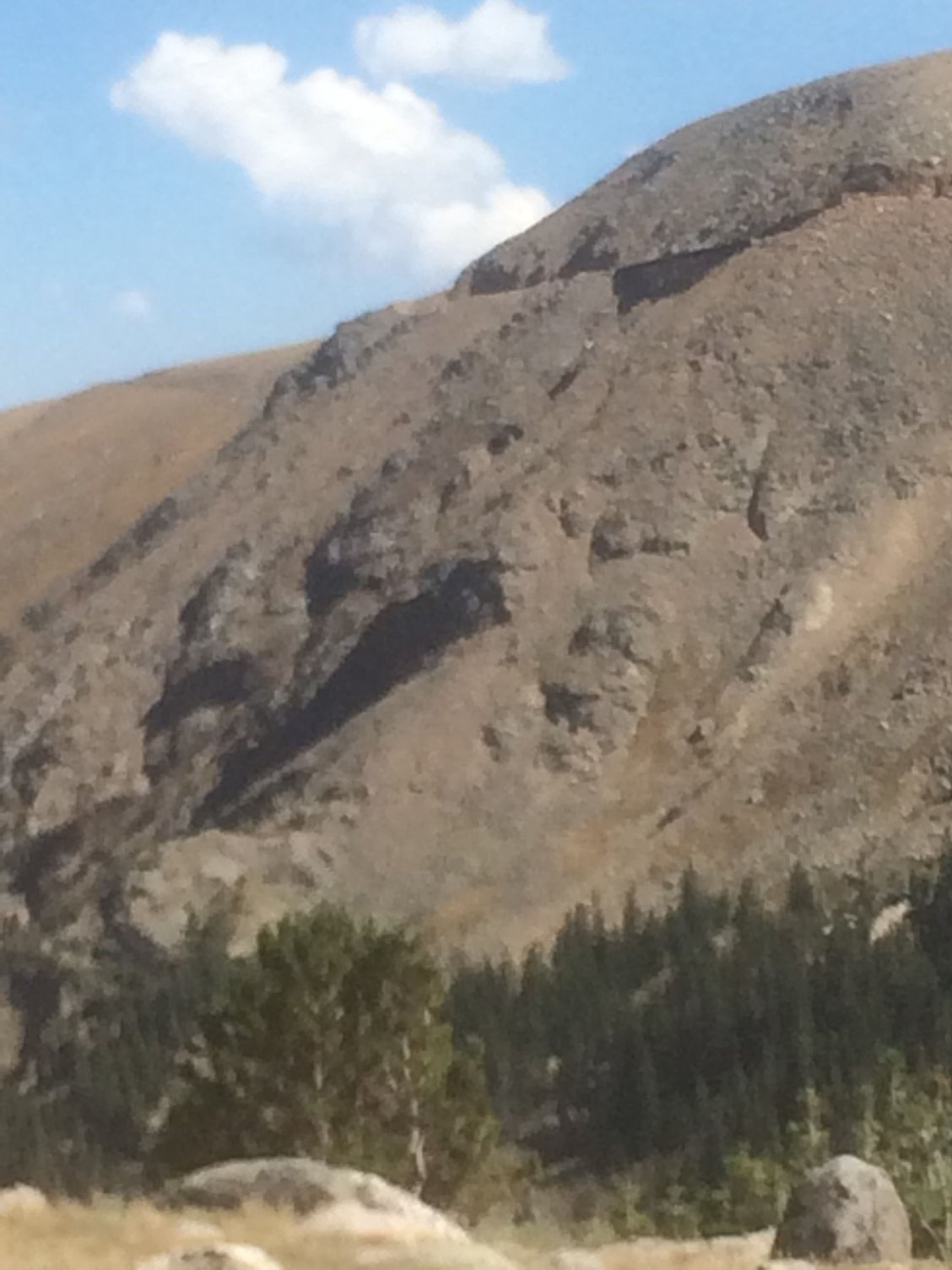
Rollins Pass also has Riflesight Notch trestle and (collapsed) tunnel.
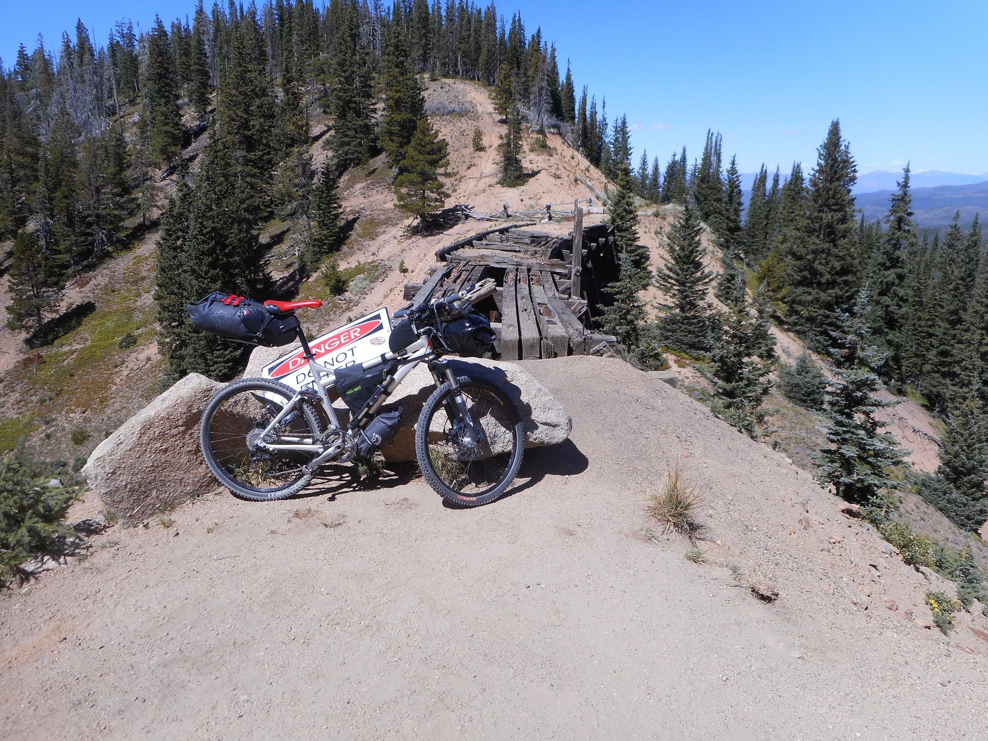
It was part of a 2+ mile loop that allowed the trains to descend a steep bit of the terrain. The tunnel under the trestle collapsed a long time ago.
I’ve been over the pass many, many times both by car and on a bicycle. It’s breathtaking every time.
The view down valley from Needles Eye Tunnel
Jenny Lake with Yankee Doodle Lake in the background. Edit: That’s not Jenny Lake. It’s Pumphouse Lake on the west side. The lake in the distance is Corona Lake.
Needles Eye. It is blocked due to a cave-in. You could probably bypass it by taking the trail to the right or you can go up a steep trail a bit further south over the top.
A large part of the draw to this route is the Devil’s Slide trestles (2 of them).
While it looks like the trestle is hanging in thin (very thin at around 10,000 feet)…
…it really is! The slide drops about 1300 feet to South Boulder Creek.
I never realized how exposed it was until I was fishing on the other side of the canyon and got this picture of the trestle clinging to the side of the mountain.
Rollins Pass also has Riflesight Notch trestle and (collapsed) tunnel.
It was part of a 2+ mile loop that allowed the trains to descend a steep bit of the terrain. The tunnel under the trestle collapsed a long time ago.
I’ve been over the pass many, many times both by car and on a bicycle. It’s breathtaking every time.
__________________
Stuart Black
Dreamin' of Bemidji Down the Mississippi (in part)
Plan Epsilon Around Lake Michigan in the era of Covid
Gold Fever Three days of dirt in Colorado
Pokin' around the Poconos A cold ride around Lake Erie
Dinosaurs in Colorado A mountain bike guide to the Purgatory Canyon dinosaur trackway
Solo Without Pie. The search for pie in the Midwest.
Picking the Scablands. Washington and Oregon, 2005. Pie and spiders on the Columbia River!
Last edited by cyccommute; 12-18-25 at 10:04 AM.
12-17-25 | 07:58 PM
#21
Mad bike riding scientist
Joined: Nov 2004
Posts: 29,202
Likes: 6,283
From: Denver, CO
Bikes: Some silver ones, a red one, a black and orange one, and a few titanium ones
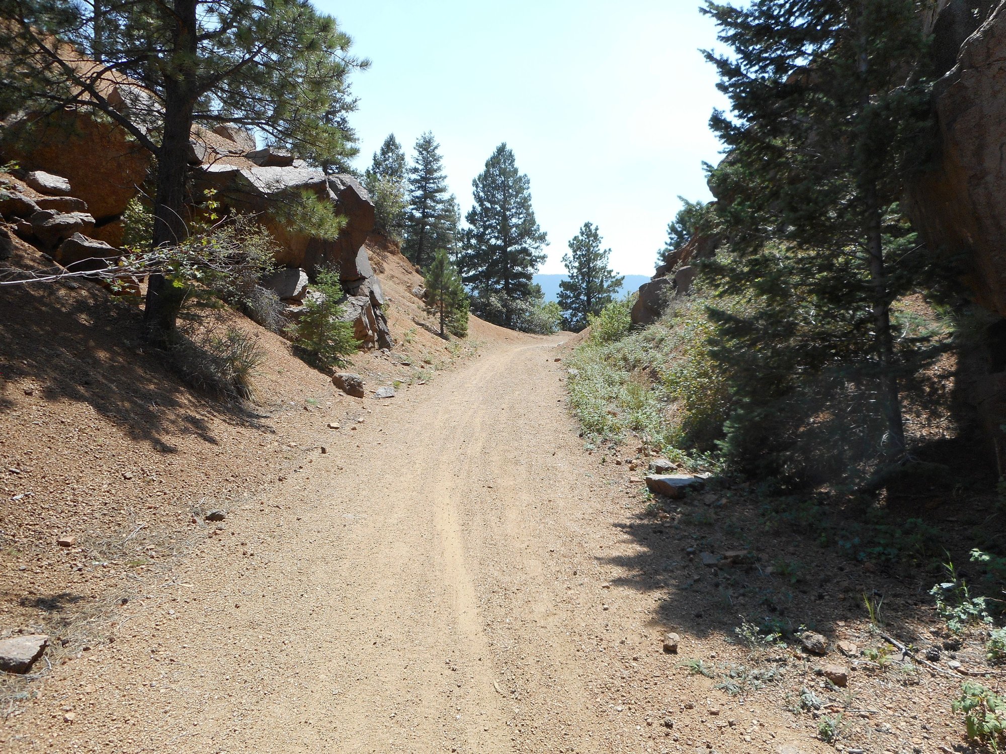
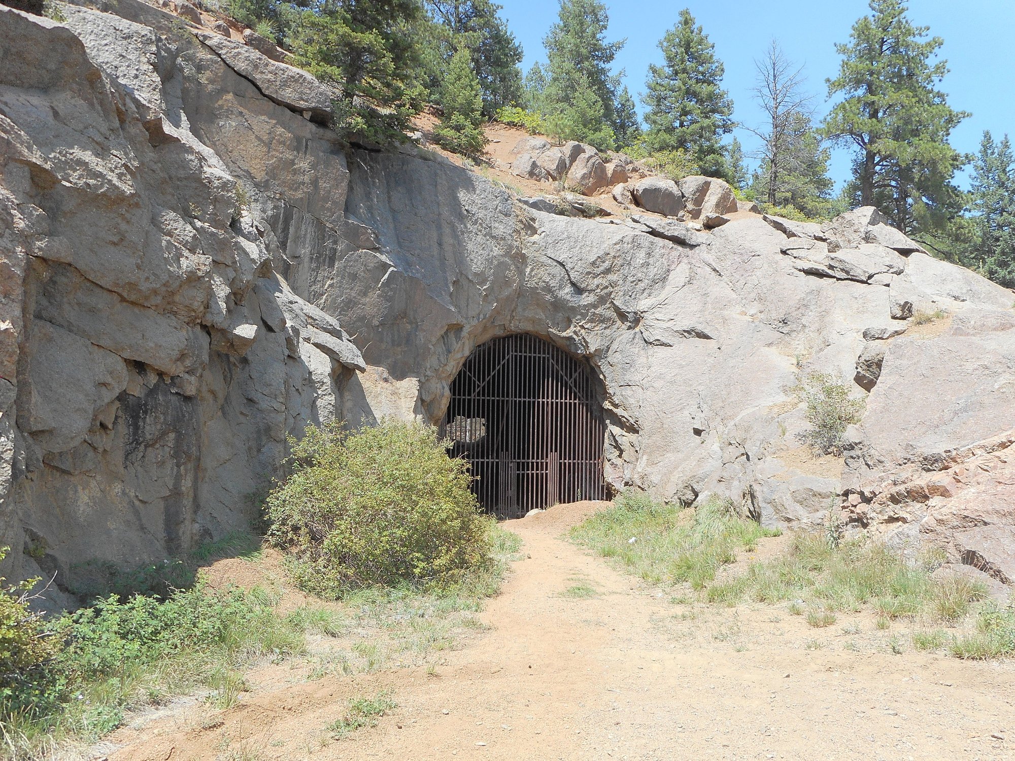
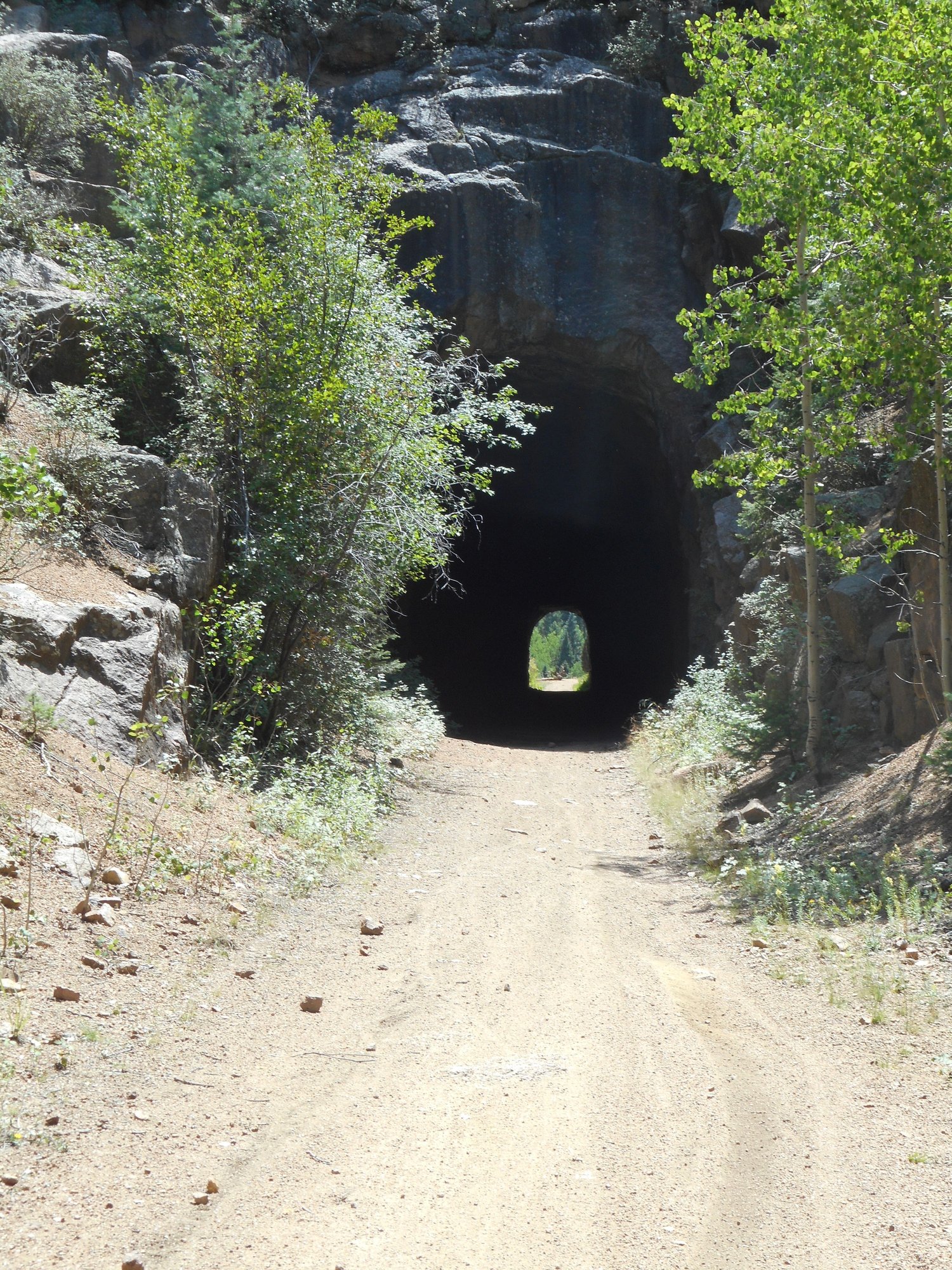
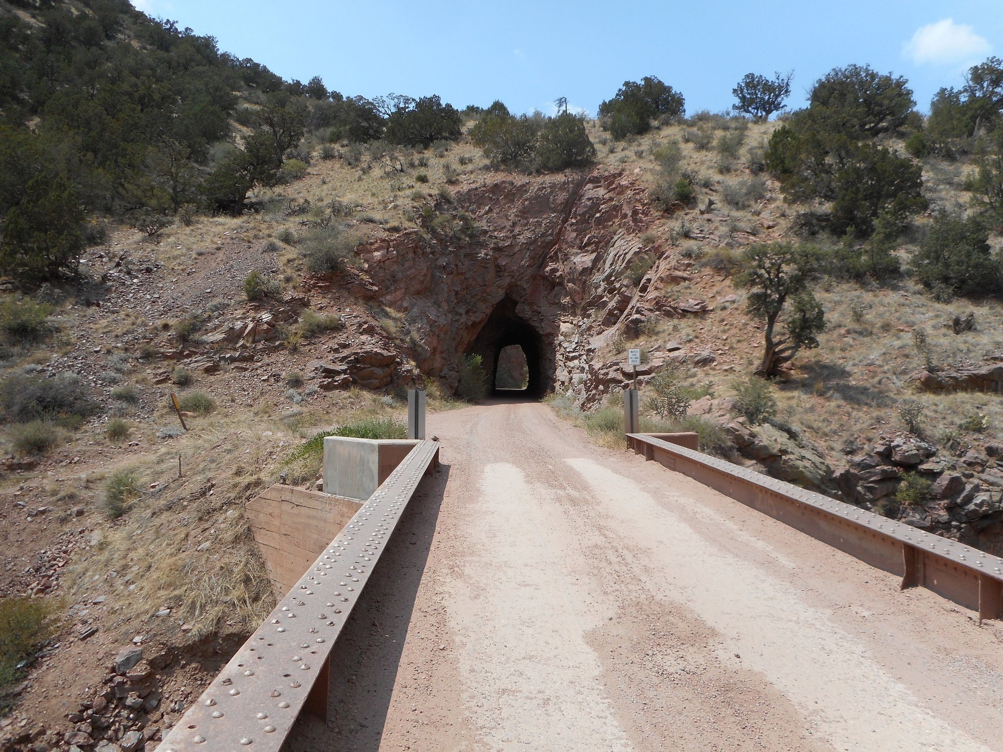
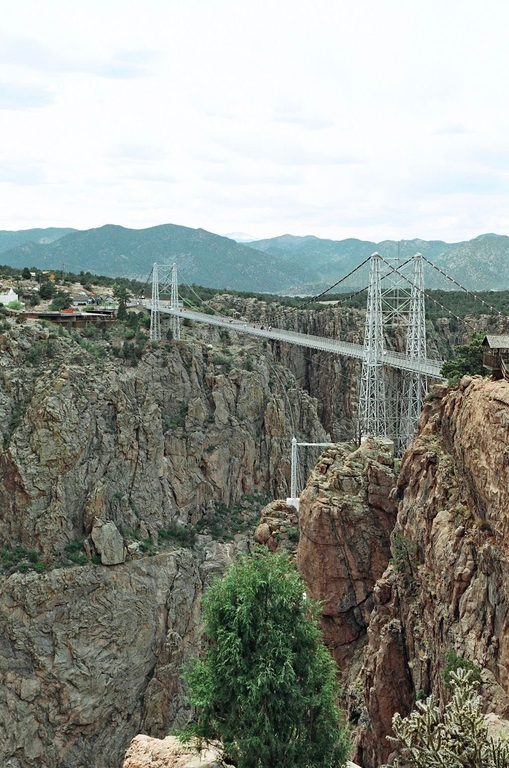
I don’t know how much time you have Stefan but here is another route that goes to Gunnison. It dips south to Colorado Springs and goes up Gold Camp Road (through about 6 tunnels) and past the approach that Zebulon Pike took to try and climb his peak. It then drops down to Ca�on City via Phantom Canyon and then over to the north side of the Royal Gorge. You can walk you bike across what was once the highest bridge in the world. Here’s some pictures of that route
Colorado Springs from Gold Camp Road.
The road is closed to car traffic after one of the tunnels which makes for a very pleasant trip.
The closed tunnel due to a collapse.
One of about 5 tunnels you get to ride through.
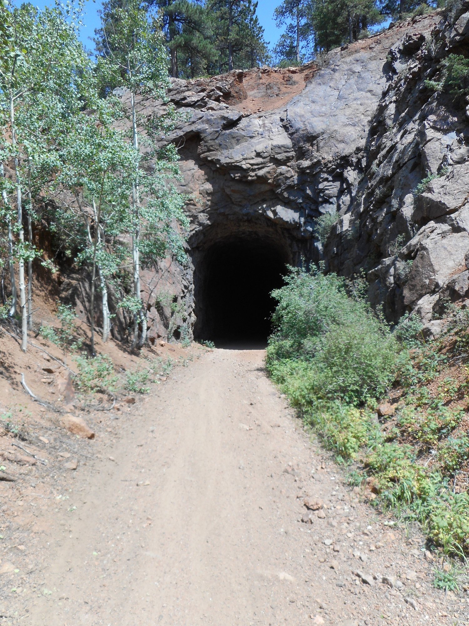
Another.
The Vindicator headframe is near the end of Gold Camp Road above Victor. There is a hiking trail to a bunch of old mine sites.

Phantom Canyon. This is a bridge that washed out in 1912 and ended the railroad.
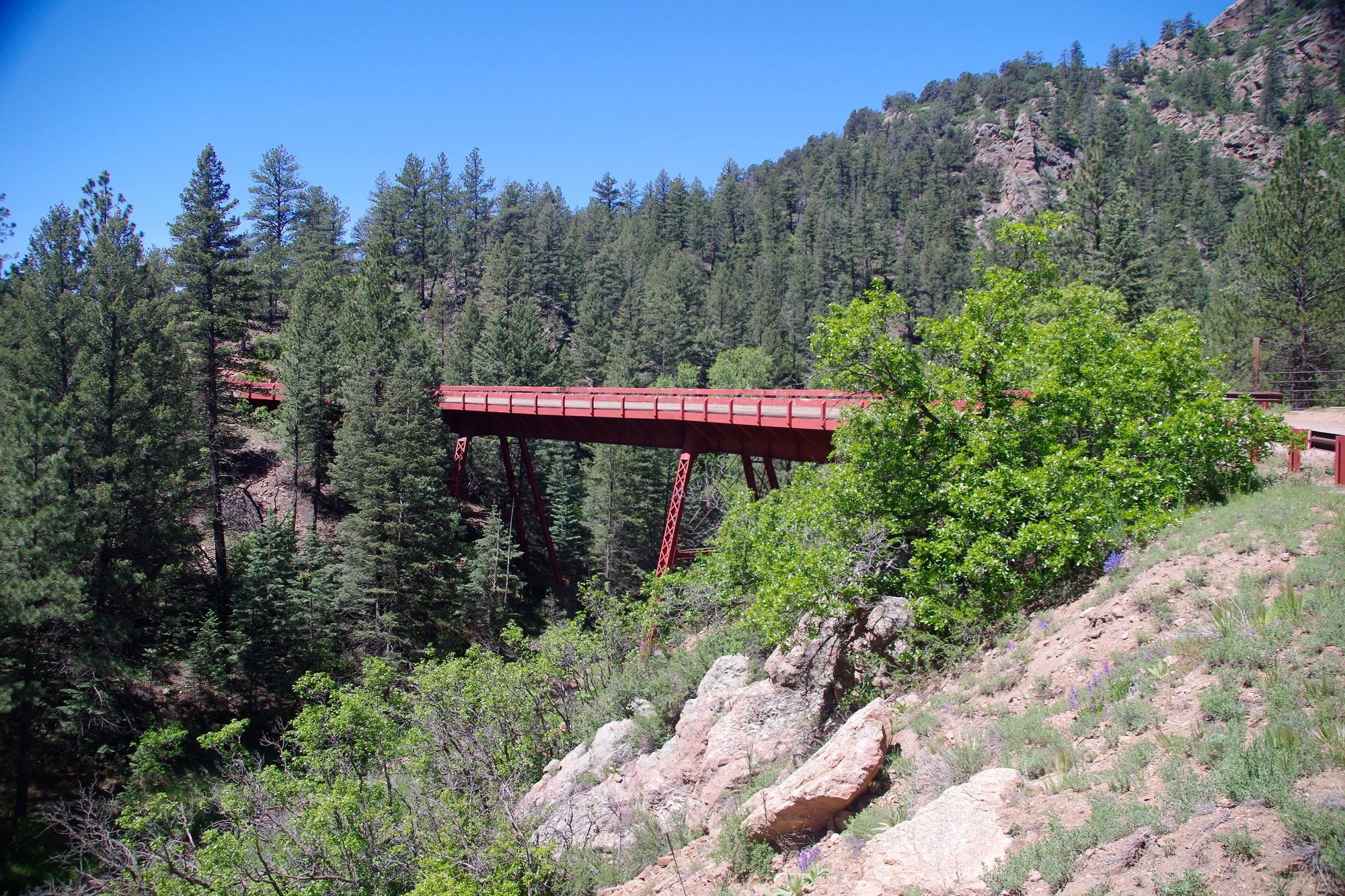

Even Phantom Canyon has tunnels.
The Royal Gorge Bridge.
Colorado Springs from Gold Camp Road.
The road is closed to car traffic after one of the tunnels which makes for a very pleasant trip.
The closed tunnel due to a collapse.
One of about 5 tunnels you get to ride through.
Another.
The Vindicator headframe is near the end of Gold Camp Road above Victor. There is a hiking trail to a bunch of old mine sites.
Phantom Canyon. This is a bridge that washed out in 1912 and ended the railroad.
Even Phantom Canyon has tunnels.
The Royal Gorge Bridge.
__________________
Stuart Black
Dreamin' of Bemidji Down the Mississippi (in part)
Plan Epsilon Around Lake Michigan in the era of Covid
Gold Fever Three days of dirt in Colorado
Pokin' around the Poconos A cold ride around Lake Erie
Dinosaurs in Colorado A mountain bike guide to the Purgatory Canyon dinosaur trackway
Solo Without Pie. The search for pie in the Midwest.
Picking the Scablands. Washington and Oregon, 2005. Pie and spiders on the Columbia River!
Stuart Black
Dreamin' of Bemidji Down the Mississippi (in part)
Plan Epsilon Around Lake Michigan in the era of Covid
Gold Fever Three days of dirt in Colorado
Pokin' around the Poconos A cold ride around Lake Erie
Dinosaurs in Colorado A mountain bike guide to the Purgatory Canyon dinosaur trackway
Solo Without Pie. The search for pie in the Midwest.
Picking the Scablands. Washington and Oregon, 2005. Pie and spiders on the Columbia River!
12-17-25 | 08:16 PM
#22
Mad bike riding scientist
Joined: Nov 2004
Posts: 29,202
Likes: 6,283
From: Denver, CO
Bikes: Some silver ones, a red one, a black and orange one, and a few titanium ones
By the way, how are you getting back from Gunnison? If you are interested, I have a route that basically covers from Littleton to Gunnison and back.
__________________
Stuart Black
Dreamin' of Bemidji Down the Mississippi (in part)
Plan Epsilon Around Lake Michigan in the era of Covid
Gold Fever Three days of dirt in Colorado
Pokin' around the Poconos A cold ride around Lake Erie
Dinosaurs in Colorado A mountain bike guide to the Purgatory Canyon dinosaur trackway
Solo Without Pie. The search for pie in the Midwest.
Picking the Scablands. Washington and Oregon, 2005. Pie and spiders on the Columbia River!
Stuart Black
Dreamin' of Bemidji Down the Mississippi (in part)
Plan Epsilon Around Lake Michigan in the era of Covid
Gold Fever Three days of dirt in Colorado
Pokin' around the Poconos A cold ride around Lake Erie
Dinosaurs in Colorado A mountain bike guide to the Purgatory Canyon dinosaur trackway
Solo Without Pie. The search for pie in the Midwest.
Picking the Scablands. Washington and Oregon, 2005. Pie and spiders on the Columbia River!
12-18-25 | 08:01 AM
#23
Thread Starter
Senior Member
Joined: Sep 2013
Posts: 1,671
Likes: 1,907
From: Spain
Thanks Stuart, will study all your great inputs in depth, be sure. great stuff. We will have 4 max 5weeks. since I saw that people leave Denver by bus to cycle there. I thought we could go back to Denver by bus. We can also go from Denver by bus, somehow I like the idea to ride to the place.
__________________
https://stefanrohner.exposure.co
https://stefanrohner.exposure.co
12-18-25 | 08:08 AM
#24
Thread Starter
Senior Member
Joined: Sep 2013
Posts: 1,671
Likes: 1,907
From: Spain
__________________
https://stefanrohner.exposure.co
https://stefanrohner.exposure.co
