


Elevation gain variance
 07-16-22 | 01:36 PM
#1
Thread Starter
Junior Member
Joined: Jun 2019
Posts: 143
Likes: 41
Bikes: Trek Domane SL5
Elevation gain variance
We rode the same trail today with a large variance between results.
Wahoo ELEMNT Bolt. 220 ft
Apple Watch 7. 385 ft
i expect a difference between devices but this seems rather large. At a quick glance the elevation map profiles appear similar. Anyone know if they use different algorithms?
Wahoo ELEMNT Bolt. 220 ft
Apple Watch 7. 385 ft
i expect a difference between devices but this seems rather large. At a quick glance the elevation map profiles appear similar. Anyone know if they use different algorithms?
 07-16-22 | 01:57 PM
#2
Senior Member


Joined: May 2021
Posts: 3,128
Likes: 2,334
From: San Francisco
Bikes: addict, aethos, creo, vanmoof, sirrus, public ...
We rode the same trail today with a large variance between results.
Wahoo ELEMNT Bolt. 220 ft
Apple Watch 7. 385 ft
i expect a difference between devices but this seems rather large. At a quick glance the elevation map profiles appear similar. Anyone know if they use different algorithms?
Wahoo ELEMNT Bolt. 220 ft
Apple Watch 7. 385 ft
i expect a difference between devices but this seems rather large. At a quick glance the elevation map profiles appear similar. Anyone know if they use different algorithms?
1) the barometric altimeter
2) GPS altitude - essentially useless
3) elevation from maps by correlating GPS location
different software will absolutely use different methods to reconcile the variation between these three sources.
07-16-22 | 02:39 PM
#3
Thread Starter
Junior Member
Joined: Jun 2019
Posts: 143
Likes: 41
Bikes: Trek Domane SL5
both devices have a barometric altimeter and GPS. what apps/software are you using to view the results? many map based systems (e.g. strava) will correct the device altitude readings based on map data. said map data varies in quality greatly, so you have three different potential altitude sources:
1) the barometric altimeter
2) GPS altitude - essentially useless
3) elevation from maps by correlating GPS location
different software will absolutely use different methods to reconcile the variation between these three sources.
1) the barometric altimeter
2) GPS altitude - essentially useless
3) elevation from maps by correlating GPS location
different software will absolutely use different methods to reconcile the variation between these three sources.
07-17-22 | 12:43 AM
#5
Full Member

Joined: Aug 2013
Posts: 325
Likes: 59
From: Spokane Area
Bikes: 2021 Salsa Warbird, (Specially Love my) 2021 Salsa Cutthroat, 2012 Surly LHT, 2015 Surly Cross-Check, 2008 Giant OCR A1, 2005 Leader 735R, 2005 Gary Fisher Montare, 1991 Nishiki Pueblo,
We rode the same trail today with a large variance between results.
Wahoo ELEMNT Bolt. 220 ft
Apple Watch 7. 385 ft
i expect a difference between devices but this seems rather large. At a quick glance the elevation map profiles appear similar. Anyone know if they use different algorithms?
Wahoo ELEMNT Bolt. 220 ft
Apple Watch 7. 385 ft
i expect a difference between devices but this seems rather large. At a quick glance the elevation map profiles appear similar. Anyone know if they use different algorithms?
07-17-22 | 01:23 AM
#6

Senior Member
Joined: Feb 2015
Posts: 6,006
Likes: 2,286
From: Mission Viejo
Bikes: 1986 Cannondale SR400 (Flat bar commuter), 1988 Cannondale Criterium XTR, 1992 Serotta T-Max, 1995 Trek 970
My personal rule of thumb has always been to mix-n-match using the best numbers. One gives more elevation, the other more miles, use them both and toss out the lower numbers.
I would guess that for the vast majority the numbers really don’t matter. If it helps to make you feel better about yourself, who cares.
I remember when our boss wanted everyone in our dept to participate in recording daily steps. We all got clip on pedometers. I’d clip it on and drive to work. I was breezing through each day until I noticed my drive registered around 4000 steps each way. Oh well, I guess I deserve some credit for fighting traffic for almost an hour to work and an hour back. There were no prizes, but 10,000 steps were never so easy.
John
Last edited by 70sSanO; 07-17-22 at 01:26 AM.
07-17-22 | 06:04 AM
#7
Senior Member

Joined: May 2017
Posts: 2,419
Likes: 2,270
From: Hacienda Hgts
Bikes: 2026 Motobecane Mulekick 520 Steel 1999 Schwinn Peloton Ultegra 10, Kestrel RT-1000 Ultegra, Trek Marlin 6 Deore 29'er
I gave up on recording with my Garmin Vivoactive. Always gave me wildly inflated #'s compared to mapping software like ridewithgps.
I want accuracy not a pat on the back.
I want accuracy not a pat on the back.
07-17-22 | 07:20 AM
#8
Senior Member
Joined: Feb 2016
Posts: 1,860
Likes: 821
From: SE Wisconsin
Bikes: Lemond '01 Maillot Jaune, Lemond '02 Victoire, Lemond '03 Poprad, Lemond '03 Wayzata DB conv(Poprad), '79 AcerMex Windsor Carrera Professional(pur new), '88 GT Tequesta(pur new), '01 Bianchi Grizzly, 1993 Trek 970 DB conv, Trek 8900 DB conv
Lots of folks buying lots of electronics that are essentially random number generators and then spending their time trying to figure out why they make little sense. Unless you figure out how to calibrate/verify what these "instruments" (being generous in many cases) are indicating, there's no reason to assume they're offering useful data. They may be consistent within themselves (i.e. they have precision) and may be useful under that umbrella(only), but without verified accuracy they have little connection to reality..or other devices. Toss in the software that lays on top of all theses devices..yikes. (imho..as a retired chemist that is familiar with real instrumentation as well as gage R&R instrument capability analysis)
07-17-22 | 08:37 AM
#9
Facts just confuse people

Joined: Jul 2017
Posts: 19,268
Likes: 7,024
From: Mississippi
Bikes: Tarmac Disc Comp Di2 - 2020
Who cares which is correct? If they are consistent in their reporting, then you'll know which route has more climbing and descending in it.
I wouldn't expect two different devices to report elevation gain loss the same way. If we really got to talking about it I doubt that even we would agree what constitutes elevation gain or loss.
If I'm on a fairly level road that goes up and down a foot 20 times over the course of a mile do I count that as 20 feet of gain/loss? What if it's 5 feet 20 times in one mile?
07-17-22 | 09:02 AM
#10
Newbie
Joined: Jun 2022
Posts: 26
Likes: 12
If I'm on a fairly level road that goes up and down a foot 20 times over the course of a mile do I count that as 20 feet of gain/loss?
Sure, as it's valid elevation gain/loss, but you'd never measure it accurately and, as you noted, it's not worth even considering.
What if it's 5 feet 20 times in one mile?
Then it's 100 feet, you'd still never measure it accurately.
07-17-22 | 09:04 AM
#11
Senior Member


Joined: Jan 2010
Posts: 45,133
Likes: 23,328
Where I see a big difference between map sources is between Google Maps and RWGPS. I�ll get, say a 49 mile route from the former and then plot in on tha latter. The former will show something like 2,500�. The latter has shown nearly 1,000� more.
 07-17-22 | 09:17 AM
#12
Senior Member
Joined: May 2021
Posts: 3,128
Likes: 2,334
From: San Francisco
Bikes: addict, aethos, creo, vanmoof, sirrus, public ...
Who cares which is correct? If they are consistent in their reporting, then you'll know which route has more climbing and descending in it.
I wouldn't expect two different devices to report elevation gain loss the same way. If we really got to talking about it I doubt that even we would agree what constitutes elevation gain or loss.
If I'm on a fairly level road that goes up and down a foot 20 times over the course of a mile do I count that as 20 feet of gain/loss? What if it's 5 feet 20 times in one mile?
I wouldn't expect two different devices to report elevation gain loss the same way. If we really got to talking about it I doubt that even we would agree what constitutes elevation gain or loss.
If I'm on a fairly level road that goes up and down a foot 20 times over the course of a mile do I count that as 20 feet of gain/loss? What if it's 5 feet 20 times in one mile?
if you really dig into it, it just gets worse. the underlying data that strava uses for elevation correction is not that great. i've compared it to known-good data (surveys and other directly-measured elevation datums) and it's pretty far off in places. 15 to 20 percent error in these stats is pretty regular, whatever the source.
07-17-22 | 09:20 AM
#13
Senior Member
Joined: May 2021
Posts: 3,128
Likes: 2,334
From: San Francisco
Bikes: addict, aethos, creo, vanmoof, sirrus, public ...
yep. different underlying terrain models, different degrees of precision in those models and the way they interpolate the "2D" points onto the underlying model... and then just the inherent problems of that methodology. it took RwGPS about 10 years to not register riding across the golden gate bridge as dropping 200' to sea level, and then abruptly climbing 200' back up. an extreme example, but 400 additional feet of climbing per round trip.
07-17-22 | 10:14 AM
#14
Senior Member
Joined: Jan 2010
Posts: 45,133
Likes: 23,328
yep. different underlying terrain models, different degrees of precision in those models and the way they interpolate the "2D" points onto the underlying model... and then just the inherent problems of that methodology. it took RwGPS about 10 years to not register riding across the golden gate bridge as dropping 200' to sea level, and then abruptly climbing 200' back up. an extreme example, but 400 additional feet of climbing per round trip.
07-17-22 | 10:48 AM
#15
Senior Member
Joined: Feb 2016
Posts: 1,860
Likes: 821
From: SE Wisconsin
Bikes: Lemond '01 Maillot Jaune, Lemond '02 Victoire, Lemond '03 Poprad, Lemond '03 Wayzata DB conv(Poprad), '79 AcerMex Windsor Carrera Professional(pur new), '88 GT Tequesta(pur new), '01 Bianchi Grizzly, 1993 Trek 970 DB conv, Trek 8900 DB conv
https://ridewithgps.com/help/advance...tten-elevation
07-17-22 | 11:08 AM
#16
Senior Member
Joined: Feb 2016
Posts: 1,860
Likes: 821
From: SE Wisconsin
Bikes: Lemond '01 Maillot Jaune, Lemond '02 Victoire, Lemond '03 Poprad, Lemond '03 Wayzata DB conv(Poprad), '79 AcerMex Windsor Carrera Professional(pur new), '88 GT Tequesta(pur new), '01 Bianchi Grizzly, 1993 Trek 970 DB conv, Trek 8900 DB conv
Precision is "repeatability"(in the science and engineering worlds). An instrument can be highly precise and yet be completely inaccurate at the same time. Accuracy is an instrument's ability to measure a correct or theoretically correct value. All measurements are estimates of some true value. A good estimate of a true value is an average of multiple measurements.
Maps or reported elevation estimates need to be accurate. With any luck, they were developed with accurate and precise instruments.
07-17-22 | 02:34 PM
#17
Senior Member
Joined: Apr 2007
Posts: 7,730
Likes: 1,720
My personal rule of thumb has always been to mix-n-match using the best numbers. One gives more elevation, the other more miles, use them both and toss out the lower numbers.
I would guess that for the vast majority the numbers really don�t matter. If it helps to make you feel better about yourself, who cares.
I remember when our boss wanted everyone in our dept to participate in recording daily steps. We all got clip on pedometers. I�d clip it on and drive to work. I was breezing through each day until I noticed my drive registered around 4000 steps each way. Oh well, I guess I deserve some credit for fighting traffic for almost an hour to work and an hour back. There were no prizes, but 10,000 steps were never so easy.
John
07-17-22 | 02:41 PM
#18
Senior Member
Joined: May 2021
Posts: 3,128
Likes: 2,334
From: San Francisco
Bikes: addict, aethos, creo, vanmoof, sirrus, public ...
Not to be too anal(or pedantic if the last word was aced), but when talking about accuracy and precision it's best to use specific/correct terms.
Precision is "repeatability"(in the science and engineering worlds). An instrument can be highly precise and yet be completely inaccurate at the same time. Accuracy is an instrument's ability to measure a correct or theoretically correct value. All measurements are estimates of some true value. A good estimate of a true value is an average of multiple measurements.
Maps or reported elevation estimates need to be accurate. With any luck, they were developed with accurate and precise instruments.
in addition to the lack of spatial resolution, when the data is generated by remote sensing (as it usually is) things like trees, buildings, etc can make the sampled point just completely inaccurate. combine that with the low resolution, possible inaccuracy of the placement of the road on the map, the user's GPS position on the map, which may or may not be snapped to the road... and it's actually surprising to me that they aren't off by even MORE!
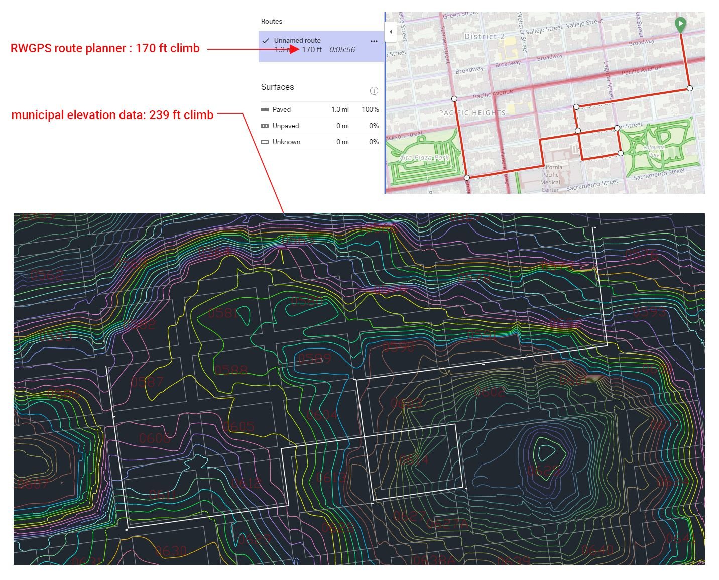
here's an example of a couple block spin around my neighborhood. RwGPS terrain model thinks it's a 1.3 mile segment with 170 feet of climbing. it's actually 1.25 miles (no way to know if RwGPS knows that but is just rounding...) and 239 feet of climbing. the actual vertical gain is almost 41 percent more! i've seen errors like this all over the place, with both strava and RwGPS, but there aren't all that many places in the world that "good" data is easy to come by.
Last edited by mschwett; 07-17-22 at 02:47 PM.
07-17-22 | 03:27 PM
#19
Senior Member
Joined: Feb 2015
Posts: 6,006
Likes: 2,286
From: Mission Viejo
Bikes: 1986 Cannondale SR400 (Flat bar commuter), 1988 Cannondale Criterium XTR, 1992 Serotta T-Max, 1995 Trek 970
I have also found that the degree to which I round up is in direct proportion to my age.
So far I have not yet resorted to metric distances. However, I anticipate doing so sometime in the future.
I also think many non-cyclists will be more impressed with kilometers, it just sounds further.
John
Edit added: Or a metric half century.
Last edited by 70sSanO; 07-17-22 at 03:36 PM.
07-17-22 | 04:50 PM
#20
Senior Member
Joined: Feb 2016
Posts: 1,860
Likes: 821
From: SE Wisconsin
Bikes: Lemond '01 Maillot Jaune, Lemond '02 Victoire, Lemond '03 Poprad, Lemond '03 Wayzata DB conv(Poprad), '79 AcerMex Windsor Carrera Professional(pur new), '88 GT Tequesta(pur new), '01 Bianchi Grizzly, 1993 Trek 970 DB conv, Trek 8900 DB conv
...imprecise..while I get your meaning..imprecise, precise and precision are very different words. The latter, in science, is basically a reserved term/professional jargon that only involves measurement repeatability. Detail and "precision" have no relationship. What the non-science/engineering world does with these words, in their own environment, including Webster's Dictionary, is up to them.
As for for my initial comments.. the random number generation applies to watts..calories burned, watches counting steps...... The devices may be useful in terms of individual unit precision, comparing output to other's results or reality will have limited success.
As for for my initial comments.. the random number generation applies to watts..calories burned, watches counting steps...... The devices may be useful in terms of individual unit precision, comparing output to other's results or reality will have limited success.
07-17-22 | 04:51 PM
#21

climber has-been

Joined: Dec 2004
Posts: 9,144
Likes: 6,037
From: Palo Alto, CA
Bikes: Scott Addict RC Pro & R1, Felt Z1
yes. you're correct. the issue with the terrain models is actually not so simple - they are precise in the sense of repeatability - if you project the same 2d coordinate onto the model you will of course always get exactly the same result. but the frequency of sampling of the underlying data is very poor, which makes it inaccurate in a way that could also be described as imprecise. not in the sense of repeatability but in the sense of "lacking exactness and accuracy of expression or detail." (per the definition of imprecise.)
in addition to the lack of spatial resolution, when the data is generated by remote sensing (as it usually is) things like trees, buildings, etc can make the sampled point just completely inaccurate. combine that with the low resolution, possible inaccuracy of the placement of the road on the map, the user's GPS position on the map, which may or may not be snapped to the road... and it's actually surprising to me that they aren't off by even MORE!
here's an example of a couple block spin around my neighborhood. RwGPS terrain model thinks it's a 1.3 mile segment with 170 feet of climbing. it's actually 1.25 miles (no way to know if RwGPS knows that but is just rounding...) and 239 feet of climbing. the actual vertical gain is almost 41 percent more! i've seen errors like this all over the place, with both strava and RwGPS, but there aren't all that many places in the world that "good" data is easy to come by.
When calculating vertical gain, the length of your ruler has a significant impact on the answer. Even if your elevation data are perfect.
__________________
Ride, Rest, Repeat. ROUVY: terrymorse

Ride, Rest, Repeat. ROUVY: terrymorse
07-17-22 | 05:35 PM
#22
Senior Member
Joined: May 2021
Posts: 3,128
Likes: 2,334
From: San Francisco
Bikes: addict, aethos, creo, vanmoof, sirrus, public ...
i�ve done it before by projecting the line onto the surface created by the contour data and the using a script to sum any positive differences between subsequent points on the line. the projection algorithm introduces vertices wherever there needs to be a kink last a certain degree of variance.
it�s worth noting that the contour data is itself created by interpolation from a (very, very large) number of points, so it�s not perfect either. but it�s within inches in most of the dozens of locations that i�ve spot checked it against surveys of actual pieces of property. data like this is very hard to come by at the scale needed for something like cycling.
07-17-22 | 06:12 PM
#23
Senior Member
Joined: Jan 2010
Posts: 45,133
Likes: 23,328
RWGPS introduced a "Flatten Elevation" tool a couple-few years back to eliminate the up and down spikes from tunneled hills and gorges. It's a premium feature. I haven't used it(not a premium acct), but the functionality is pretty straight forward. They have a demo of it on their site somewhere.
https://ridewithgps.com/help/advance...tten-elevation
https://ridewithgps.com/help/advance...tten-elevation
 07-17-22 | 07:08 PM
#24
Senior Member
Joined: May 2021
Posts: 3,128
Likes: 2,334
From: San Francisco
Bikes: addict, aethos, creo, vanmoof, sirrus, public ...
https://ridewithgps.com/news/5657-br...a-improve?otu=
worth noting that the auto version doesn�t work for rides, just routes:
 07-18-22 | 05:54 AM
#25
Senior Member
Joined: Feb 2016
Posts: 1,860
Likes: 821
From: SE Wisconsin
Bikes: Lemond '01 Maillot Jaune, Lemond '02 Victoire, Lemond '03 Poprad, Lemond '03 Wayzata DB conv(Poprad), '79 AcerMex Windsor Carrera Professional(pur new), '88 GT Tequesta(pur new), '01 Bianchi Grizzly, 1993 Trek 970 DB conv, Trek 8900 DB conv
My ignore list is up to 88..and continues it's slow growth.