


Regional rules for routing
 08-01-16 | 03:02 PM
#1
Thread Starter
Senior Member
Joined: Aug 2011
Posts: 1,251
Likes: 17
Regional rules for routing
Some areas are very easy to route through when you want to stay on pavement, go anywhere you find a road, aka northern 2/3rds of Ohio...everything is paved. KY is much the same way, while MN is quite the exact opposite(if not on a highway or in town plan on being on gravel). I've been doing the 20th or 30th route plan for this years trip since it keeps changing with passing week as to what I'm going to do and my most recent routing has kinda surprised me with the amount of non-highway miles that are paved. The area in question, especially the western side of the area I would have figured would have been mostly gravel and I haven't found a gravel road in the area yet looking at streeview.
I'm wandering, and figuring this is region to region, aka in some case state to state, like Ohio, but in other places it may be just part of a state that has tons of gravel while other parts are pretty much all paved roads. It makes the planning much simpler when you have a pretty decent idea ahead of time which to expect. I realize you can use streetview to get the google car view of the roads in question but that still takes time and I'm looking for the 'sneak' tips to make it even quicker for coming up with routes without having to jump over to streetview.
Outside of incorporated areas(towns or cities) and off of the highways are their any areas/regions that quite well known for either or predominantly gravel or predominantly paved...and where are those areas?
 08-01-16 | 03:15 PM
#2


Texas:
Freeways- avoid altogether
Other highways- usually rideable, but not ideal
FM Roads in rural areas- preferred routes, usually
County roads- maybe paved, maybe not
Oklahoma-
State highways in rural areas, usually pretty good.
Freeways- avoid altogether
Other highways- usually rideable, but not ideal
FM Roads in rural areas- preferred routes, usually
County roads- maybe paved, maybe not
Oklahoma-
State highways in rural areas, usually pretty good.
__________________
"be careful this rando stuff is addictive and dan's the 'pusher'."
"be careful this rando stuff is addictive and dan's the 'pusher'."
08-01-16 | 03:51 PM
#3
Senior Member

Joined: Dec 2010
Posts: 9,686
Likes: 2,605
From: northern Deep South
Bikes: Fuji Touring, Novara Randonee
North Carolina: the state owns all the roads, so they're almost all "paved." There may be chuckholes large enough to swallow a dump truck in the mountains, but they're still paved. Exceptions are federal roads (forest service roads, national park roads, between state roads and the Blue Ridge Parkway, etc), which may be gravel.
In Tennessee and Alabama, most roads are paved. If it's gravel, it's probably a driveway, dead end lane, or forest service road. It's worth consulting a good map to figure out if that nicely paved road goes anywhere besides down a steep gully to a dead end.
Tennessee's major U.S. highways have been getting four-lane treatment the last 20 years, usually with shoulders. Stay off two-lane U.S. highways there to the extent possible, unless it's adjacent to an interstate. State roads are usually good cycling choices away from major towns, good pavement and low traffic. County roads run the gamut.
Alabama, stay off U.S. highways to the extent possible (unless adjacent to an interstate). State roads are often viable >30 miles from a city, but if there's a county road parallel, take it. County roads are often surprisingly good, except when they're awful.
OT, I think the variability in how a region treats its roads is one of the big things that makes people either embrace or scratch their heads at the gravel-grinder bikes. If you've got miles of scenic gravel roads nearby, they're great. If the gravel roads in your area go 50 yards around a curve to a gate (and it smells like sour mash -- run away!), there's not much reason to get excited about gravel-grinders.
08-01-16 | 04:17 PM
#4
Thread Starter
Senior Member
Joined: Aug 2011
Posts: 1,251
Likes: 17
North Carolina: the state owns all the roads, so they're almost all "paved." There may be chuckholes large enough to swallow a dump truck in the mountains, but they're still paved. Exceptions are federal roads (forest service roads, national park roads, between state roads and the Blue Ridge Parkway, etc), which may be gravel.
In Tennessee and Alabama, most roads are paved. If it's gravel, it's probably a driveway, dead end lane, or forest service road. It's worth consulting a good map to figure out if that nicely paved road goes anywhere besides down a steep gully to a dead end.
Tennessee's major U.S. highways have been getting four-lane treatment the last 20 years, usually with shoulders. Stay off two-lane U.S. highways there to the extent possible, unless it's adjacent to an interstate. State roads are usually good cycling choices away from major towns, good pavement and low traffic. County roads run the gamut.
Alabama, stay off U.S. highways to the extent possible (unless adjacent to an interstate). State roads are often viable >30 miles from a city, but if there's a county road parallel, take it. County roads are often surprisingly good, except when they're awful.
OT, I think the variability in how a region treats its roads is one of the big things that makes people either embrace or scratch their heads at the gravel-grinder bikes. If you've got miles of scenic gravel roads nearby, they're great. If the gravel roads in your area go 50 yards around a curve to a gate (and it smells like sour mash -- run away!), there's not much reason to get excited about gravel-grinders.
In Tennessee and Alabama, most roads are paved. If it's gravel, it's probably a driveway, dead end lane, or forest service road. It's worth consulting a good map to figure out if that nicely paved road goes anywhere besides down a steep gully to a dead end.
Tennessee's major U.S. highways have been getting four-lane treatment the last 20 years, usually with shoulders. Stay off two-lane U.S. highways there to the extent possible, unless it's adjacent to an interstate. State roads are usually good cycling choices away from major towns, good pavement and low traffic. County roads run the gamut.
Alabama, stay off U.S. highways to the extent possible (unless adjacent to an interstate). State roads are often viable >30 miles from a city, but if there's a county road parallel, take it. County roads are often surprisingly good, except when they're awful.
OT, I think the variability in how a region treats its roads is one of the big things that makes people either embrace or scratch their heads at the gravel-grinder bikes. If you've got miles of scenic gravel roads nearby, they're great. If the gravel roads in your area go 50 yards around a curve to a gate (and it smells like sour mash -- run away!), there's not much reason to get excited about gravel-grinders.
It's just the simple matter of where to expect the non highways to be paved versus gravel. I ride 700x25s so I'm always riding pavement since I don't mind the traffic at all...put up with it around home everyday...can't get anywhere without having to deal with traffic and plenty of big rigs. I've gotten used to it.
08-01-16 | 06:45 PM
#5
Junior Member
Joined: Jan 2007
Posts: 10
Likes: 0
Bikes: 82 Raleigh Competition 531; 86 Raleigh Technium 480; 87 Trek 720
One of the ways I have used Google Maps for route planning is to zoom to the area in question, and grab the small person icon that you use to convert to street view. However, don't drop the icon on a street, just "hover it" over the entire area. All the places where street view is available will turn blue. These roads are generally paved. There may be exceptions, but so far this has worked very well for me through a number of places to include Minnesota, North Dakota, and Montana. I then spot check rather than doing an entire street view. When a paved road turns to gravel, the blue shading ends.
I did ride a road this year that was shown as paved on Google Maps and even the street view, but when we got there, the road ran right into a brand new lake. Google Maps, like printed maps, takes time to be updated. And of course there are periodic errors. I often compare Google Map data with state road maps and state bicycling maps, when available.
I did ride a road this year that was shown as paved on Google Maps and even the street view, but when we got there, the road ran right into a brand new lake. Google Maps, like printed maps, takes time to be updated. And of course there are periodic errors. I often compare Google Map data with state road maps and state bicycling maps, when available.
08-01-16 | 07:41 PM
#6

Senior Member
Joined: Apr 2015
Posts: 8,206
Likes: 86
From: Metro Detroit/AA
Bikes: 2016 Novara Mazama
Michigan can be a crapshoot. I've been on roads in Metro Detroit that go by million dollar homes that are rough dirt, and roads through the middle of nowhere leading to a trout stream that are pristine blacktop.
Personally, I don't mind gravel. Less traffic, and less painful than a poorly maintained paved road
Personally, I don't mind gravel. Less traffic, and less painful than a poorly maintained paved road
08-01-16 | 07:41 PM
#7


Non omnino gravis
Joined: Feb 2015
Posts: 8,552
Likes: 1,739
From: SoCal, USA!
Bikes: Nekobasu, Pandicorn, Lakitu
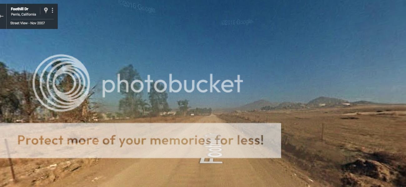
We don't have much in the way of gravel here in Southern California, sadly. What we do have, is Google Maps treating anything with a name as a street navigable by bicycle, and this is not always the case. In what we have that would count as "rural," there are vast stretches of unmaintained county farm road, which is a road easily passable by vehicle, but is usually covered in loose, very dry sand that will swallow anything smaller than an MTB tire with ease. Google Maps puts a blue line on all of them, and there's even street view on many. It tried (unsuccessfully) to send me down this washboard nightmare, complete with 9-year-old Streetview imagery:
Google Maps has tried to lead me down these "roads" many times, as have all of the route planning apps like Map My Ride, which just use Google's information. I've also been directed down roads that are, well, no longer roads. I didn't catch that one during route planning, and I ended up on what was once a street, but is now a runway for a model airplane club, and it dead ends into a drainage culvert. I got to ride down about half a mile of service road there for accessing power and cell towers. Super fun times.
Google Maps has tried to lead me down these "roads" many times, as have all of the route planning apps like Map My Ride, which just use Google's information. I've also been directed down roads that are, well, no longer roads. I didn't catch that one during route planning, and I ended up on what was once a street, but is now a runway for a model airplane club, and it dead ends into a drainage culvert. I got to ride down about half a mile of service road there for accessing power and cell towers. Super fun times.
__________________

08-01-16 | 08:38 PM
#8


That's a good point about google street view, they "usually" don't drive on gravel roads. But of course, they may just not have good coverage in the area, so no blue line doesn't mean that the road isn't paved.
I've zoomed into Satellite View, looking for painted center or edge lines, which indicates paving. But not all paved roads have lines! And some chip&seal (paved, topped with gravel and tar) look very much like gravel on satellite view.
~~~~
I've used the "USGS Scans" map view on ridewithgps.com. The Esri topo and USGS topo don't really show road styles.
Here's a local example. Very few roads in N KY are gravel, so I was surprised when I tried to ride down Holts Creek Road. It's only paved at the bottom, after the intersection with Fisher Road.
Note that the divided AA Highway, from top right to bottom right, shows as a double dashed line, indicating it's not yet built. But it's been completed there at least 10 to 15 years. So the scans may be out of date.
The example USGS map, and the USGS legend, showing road types. Colored dashed lines are major roads, not gravel! And Holts Creek shows a doubled dash line--"unimproved road" (I guess that's worse than a gravel road), and a single dashed line up the hill--even less improved.
Last edited by rm -rf; 08-01-16 at 08:52 PM.
08-02-16 | 04:14 AM
#10

Senior Member
Joined: May 2008
Posts: 7,381
Likes: 219
In Metro Boston my favorite map (paper) is the AAA Metropolitan map, which is detailed enough to find great cycling roads, yet covers enough area, of about a 50 mile radius from downtown, to even plan century routes. Invariably all roads are paved, few are pock-marked with potholes and cracks, and many have smooth blacktop.
The irritating charm of riding in metro Boston that the roads are so haphazard and confusing that it is easy to get lost. Roads intersectat various angles; often sereptitiously change names; road signs are often not there, or only on intersecting roads so you don’t know what road you’re on; and rotaries mess up your sense of direction.
From my forays into outstate Massachusets,the situation seems similar,though roads are often longer, straighter and less confusing. The charm is that the roads around here are usually interesting and/or scenic, and in getting lost you learn them better.
08-02-16 | 04:57 AM
#11
Senior Member


Joined: Jan 2010
Posts: 45,300
Likes: 23,480
+1. I have been trying to incorporate more into my trips. Did some very nice gravel in MT back in June. One was a stretch paralleling a 10 mile, shoulderless stretch of ACA's TransAm route between Sheridan and Laurin. It was so nice I sent ACA the route map and they added it to the map addenda to get feedback. Well-maintained surface. Lot's of wildlife. Some cool old buildings. And one car.
08-02-16 | 02:42 PM
#12
Senior Member
Joined: Jun 2013
Posts: 1,642
Likes: 6
From: Cedar Rapids, IA
Bikes: 1997 Rivendell Road Standard 650b conversion (tourer), 1988 Schwinn Project KOM-10 (gravel/tour), 2013 Foundry Auger disc (CX/gravel), 2016 Cannondale Fat CAAD 2 (MTB/winter), 2011 Cannondale Flash 29er Lefty (trail MTB)
Road surfaces can be totally variable in Iowa, so I go to the state transportation website and look at the county road maps. Those maps differentiate between concrete, asphalt, bituminous (chipseal), gravel, and dirt (B-road) surfaces.
Usually I'm using these maps to find the gravel and dirt to go play on, but they could be used to stay on-pavement as well.
Usually I'm using these maps to find the gravel and dirt to go play on, but they could be used to stay on-pavement as well.
08-02-16 | 03:35 PM
#13
Thread Starter
Senior Member
Joined: Aug 2011
Posts: 1,251
Likes: 17
Road surfaces can be totally variable in Iowa, so I go to the state transportation website and look at the county road maps. Those maps differentiate between concrete, asphalt, bituminous (chipseal), gravel, and dirt (B-road) surfaces.
Usually I'm using these maps to find the gravel and dirt to go play on, but they could be used to stay on-pavement as well.
Usually I'm using these maps to find the gravel and dirt to go play on, but they could be used to stay on-pavement as well.
Thanks again.
08-02-16 | 06:38 PM
#14
Gravel
If you are looking for gravel roads, instead of trying to avoid them, here's a couple of links.
The Gravel Cyclist blog had some links in this post from 2015, including state maps for Colorado, Iowa, and Pennsylvania.
And it pointed me to gravelmap.com
It shows user submitted gravel roads in yellow. You can bookmark / favorite the view since it changes the URL as you move the map.
About Gravelmap:
Gravelmap is an interactive database of gravel and dirt roads and paths, submitted and managed entirely by people who ride them.
Biking on gravel roads, or "gravel grinding," is becoming increasingly popular. While it may not be a new concept, it is one that is quickly spreading as people discover how awesome it is to explore less-traveled, quiet backroads via bicycle.
08-02-16 | 08:40 PM
#15
Senior Member
Joined: Mar 2011
Posts: 3,150
Likes: 49
Bikes: 2013 Surly Disc Trucker, 2004 Novara Randonee , old fixie , etc
Michigan can be a crapshoot. I've been on roads in Metro Detroit that go by million dollar homes that are rough dirt, and roads through the middle of nowhere leading to a trout stream that are pristine blacktop.
Personally, I don't mind gravel. Less traffic, and less painful than a poorly maintained paved road
Personally, I don't mind gravel. Less traffic, and less painful than a poorly maintained paved road
GravelMap.Com is interesting though it seems that vast # of dirt/gravel roads not listed.
08-02-16 | 09:03 PM
#16
Senior Member
Joined: Apr 2015
Posts: 8,206
Likes: 86
From: Metro Detroit/AA
Bikes: 2016 Novara Mazama
08-02-16 | 09:52 PM
#17
Senior Member
Joined: Mar 2011
Posts: 3,150
Likes: 49
Bikes: 2013 Surly Disc Trucker, 2004 Novara Randonee , old fixie , etc
Makes sense, more privacy. OTOH in the 2 local super-wealthy suburbs even some of the major arteries are antiquated 2-lane roads w/little or no shoulders. Not safe for bikes/peds & slow for cars in rush hour though they have plenty of $$ to improve if they wished.

Thread
Thread Starter
Forum
Replies
Last Post
horatio
Long Distance Competition/Ultracycling, Randonneuring and Endurance Cycling
23
10-20-10 07:59 PM
