


Pacific Coast Route
 12-01-24 | 03:20 AM
#176
aka Timi

Joined: Feb 2009
Posts: 3,611
Likes: 327
From: Gothenburg, Sweden
Bikes: Bianchi Lupo & Bianchi Volpe Disc: touring. Bianchi Volpe: commuting
 12-01-24 | 03:42 AM
#177
Thread Starter
Junior Member
Joined: Aug 2024
Posts: 101
Likes: 10
Bikes: 2018 Giant Talon 3 XL
SUCCESS..!!! Cool- got the first two main sections merged and uploaded to Komoot..! Right- I'm off for a beer... that was a lot of trail and error..! 
It takes me from VC to the Cali Stateline.
EDIT- all done..!
It takes me from VC to the Cali Stateline.
EDIT- all done..!
Last edited by meshcarver; 12-01-24 at 03:56 AM.
12-01-24 | 09:58 AM
#178
Senior Member
Joined: Jul 2010
Posts: 13,929
Likes: 1,243
From: Montreal Canada
I'd say the most important thing is that you are mucking around with this now, and figuring out and troubleshooting the hiccups well in advance.
In my private message, I mentioned reading often about how its really better to have multiple files that arent too large, and one would think the ACA stuff is divided into chunks that work properly without issues on common devices that people use.
I'm sure there are forums for the ACA route that you could find some real life user helpful hints also.
On long trips, I've always found it handy to have a few days planned out in advance, so even with modern technology, I like having even just notes down on what town I'm getting to, what grocery store I've seen is there, or whatever. Basic note planning a few days in advance is nice to have and easy to keep on top of.
On rest days, I've always gone over my bike thoroughly and also looked ahead a bit to be clear on the general routing--I like not always to be "peering at a screen" or at least to have a "bigger picture" thing in my head or on paper for the next few days anyway. Its also nice to always be a bit ahead of the route game, so you dont have to go over everything each night, especially if you are tired and just want to get camp set up, showered, your clothes cleaned and hung up to dry, eat supper and get all your crap organized in the tent for the morning departure.
Last edited by djb; 12-01-24 at 10:04 AM.
12-01-24 | 10:11 AM
#179
Senior Member
Joined: Jul 2010
Posts: 13,929
Likes: 1,243
From: Montreal Canada
oh, with whatever device you end up getting, read up properly on how to reduce battery drain.
Stuff like NOT having the gps talk all the time to your phone (putting up text or email messages on the gps as an example) or not having the screen on at maximum brightness, whatever -- all this stuff helps to get more life out of the gps, and lessen the amount of time you have to charge it.
This also helps with getting the most out of your battery bank, as they often take quite a long time to recharge, especially a 20,000 miliamp one like you have, and one does have to careful in campgrounds or whereever with theft, so you really dont want to leave things charging unattended overnight lets say--but like in life, you have to assess the situation and use judgement -- but if you get it wrong and someone steals something, you are kinda ..... well, up the creek for your trip, adding big hassles.....
My experience with a battery bank is that I can charge my garmin fairly quickly, Ive done it when doing other stuff like eating or whatever.
12-01-24 | 10:45 AM
#180
aka Timi
Joined: Feb 2009
Posts: 3,611
Likes: 327
From: Gothenburg, Sweden
Bikes: Bianchi Lupo & Bianchi Volpe Disc: touring. Bianchi Volpe: commuting
The way I use Komoot to save on data and battery is:
Save the route offline when there’s wifi.
Airplane mode.
Turn screen off.
I just listen to nav directions.
I even have a small solar panel on my rear rack which on a sunny day keeps the phone charged.
Save the route offline when there’s wifi.
Airplane mode.
Turn screen off.
I just listen to nav directions.
I even have a small solar panel on my rear rack which on a sunny day keeps the phone charged.
Last edited by imi; 12-01-24 at 10:49 AM.
12-01-24 | 02:16 PM
#181

Senior Member
Joined: Mar 2024
Posts: 1,950
Likes: 784
From: San Diego
Bikes: Columbine, Lynskey GR300, Paramount Track Bike, Colnago Super (4), Santana Tandems (1995 & 2007), Gary Fisher Piranha (retired), Bianchi Track Bike, a couple of Honda mountain bikes
I carry one of these batteries. Anker kit is great quality and this battery will power a phone with everything on for more than 12 hours.
https://www.amazon.com/gp/product/B0...?ie=UTF8&psc=1
https://www.amazon.com/gp/product/B0...?ie=UTF8&psc=1
12-02-24 | 09:52 PM
#182
Thread Starter
Junior Member
Joined: Aug 2024
Posts: 101
Likes: 10
Bikes: 2018 Giant Talon 3 XL
imi Another quick one- once I've got the Route in Komoot and then transfer it to Garmin GPS, does it automatically know each turn you need to take and will also read it out so you can hear? Or do I need to click on every (!!!) corner and add that myself? It's just a continuous blue line right now and there are no Cues I can see? How does that part work please?
12-02-24 | 10:33 PM
#183
Thread Starter
Junior Member
Joined: Aug 2024
Posts: 101
Likes: 10
Bikes: 2018 Giant Talon 3 XL
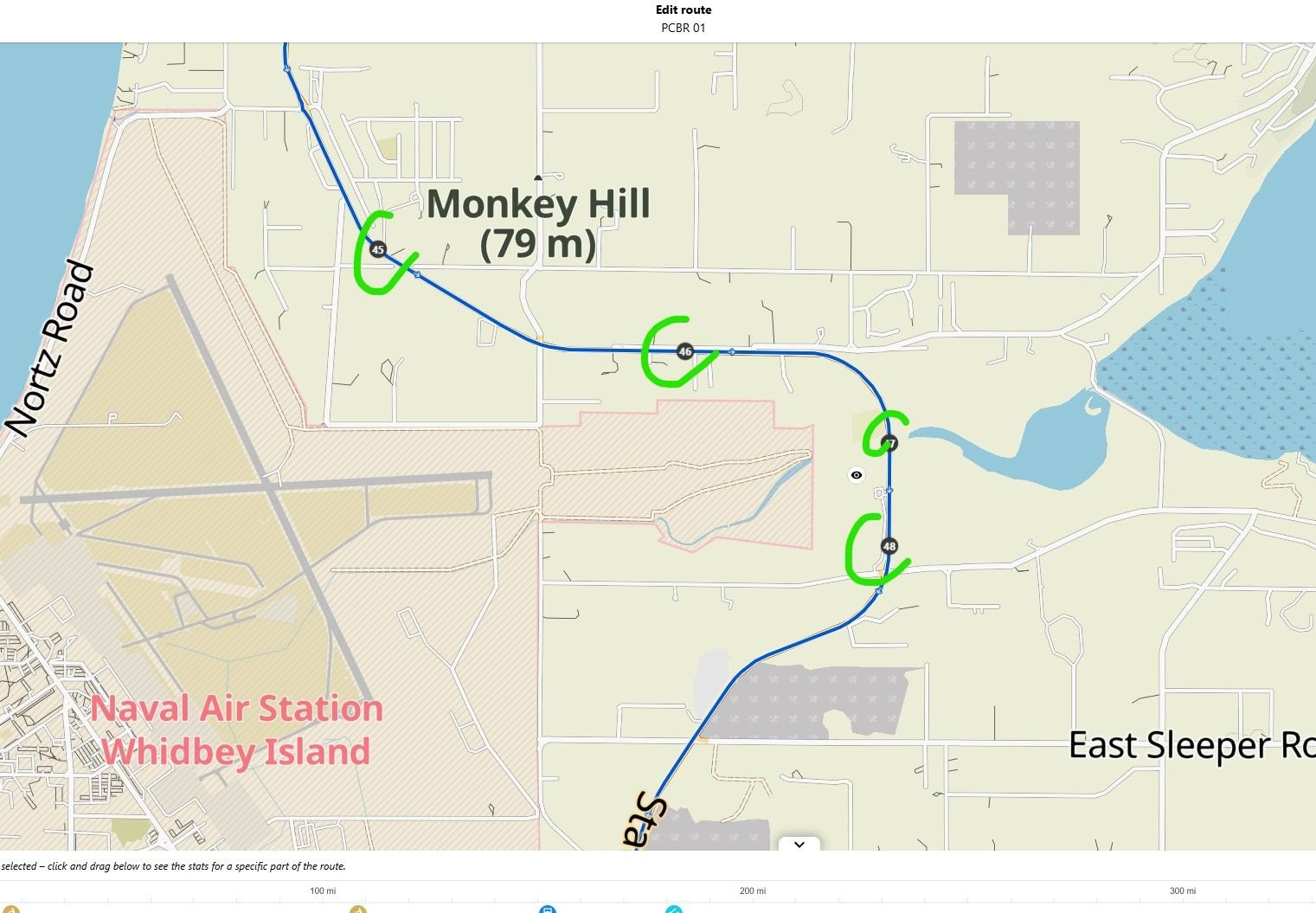
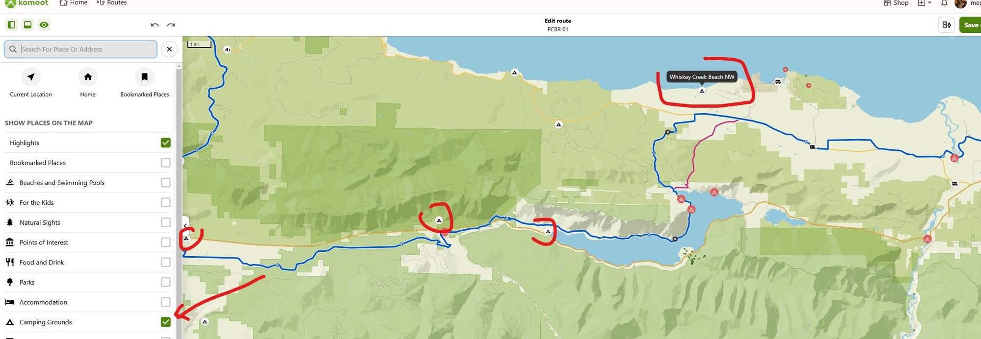
Another amateur question- these Waypoints are from the ACA GPX data.
Why are they here? As far as I can tell there's no real reason to have these four here is there? The Route continues on and they're not on any junctions?
I know I might be missing a trick here but could someone please explain to me the relevance of Waypoints and why these might be placed here guys?
Why are they here? As far as I can tell there's no real reason to have these four here is there? The Route continues on and they're not on any junctions?
I know I might be missing a trick here but could someone please explain to me the relevance of Waypoints and why these might be placed here guys?
12-02-24 | 11:10 PM
#184
Thread Starter
Junior Member
Joined: Aug 2024
Posts: 101
Likes: 10
Bikes: 2018 Giant Talon 3 XL
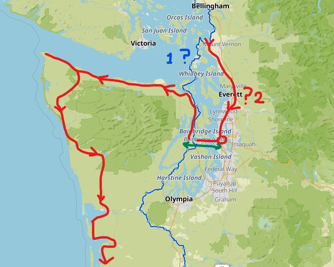
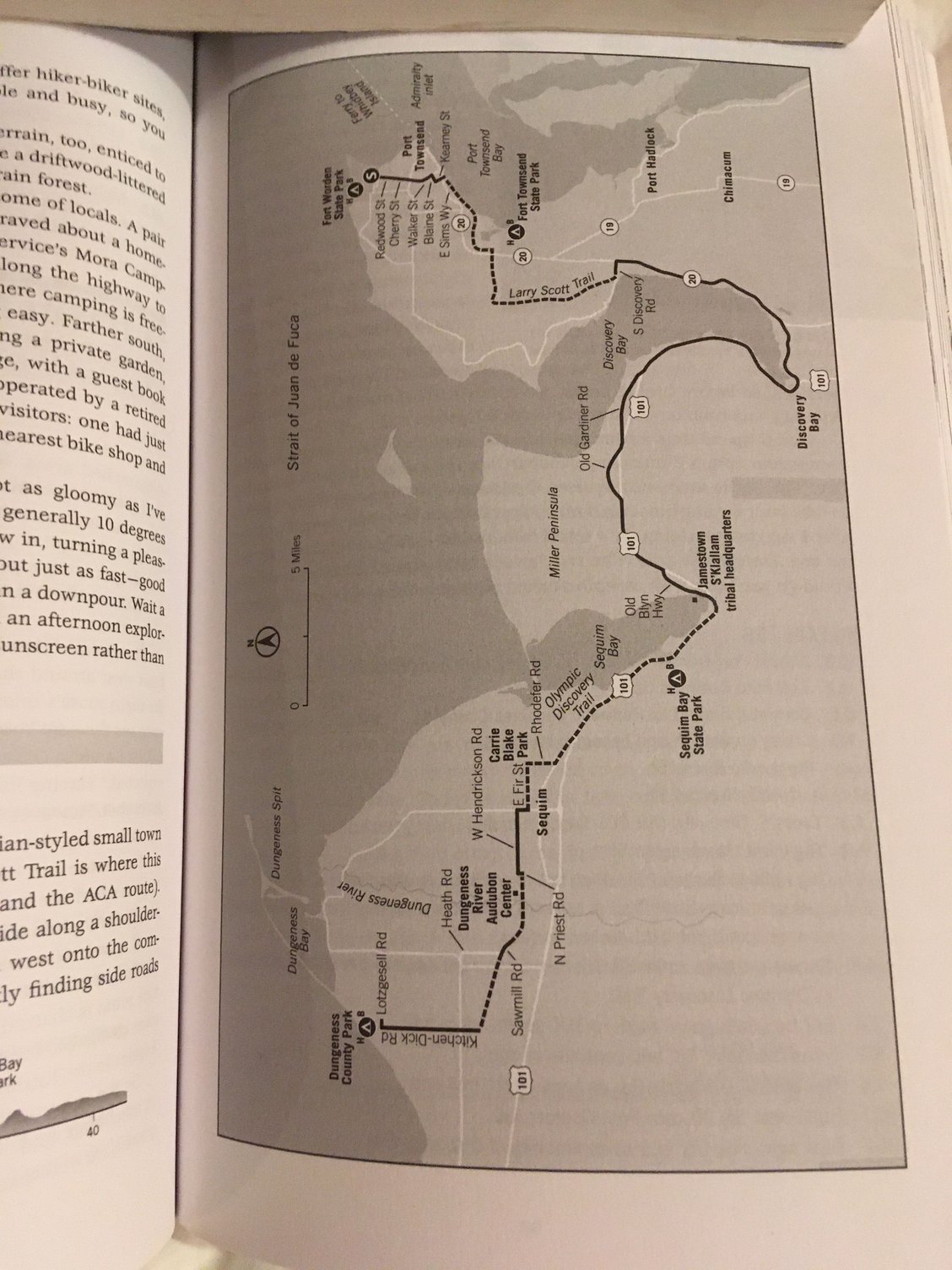
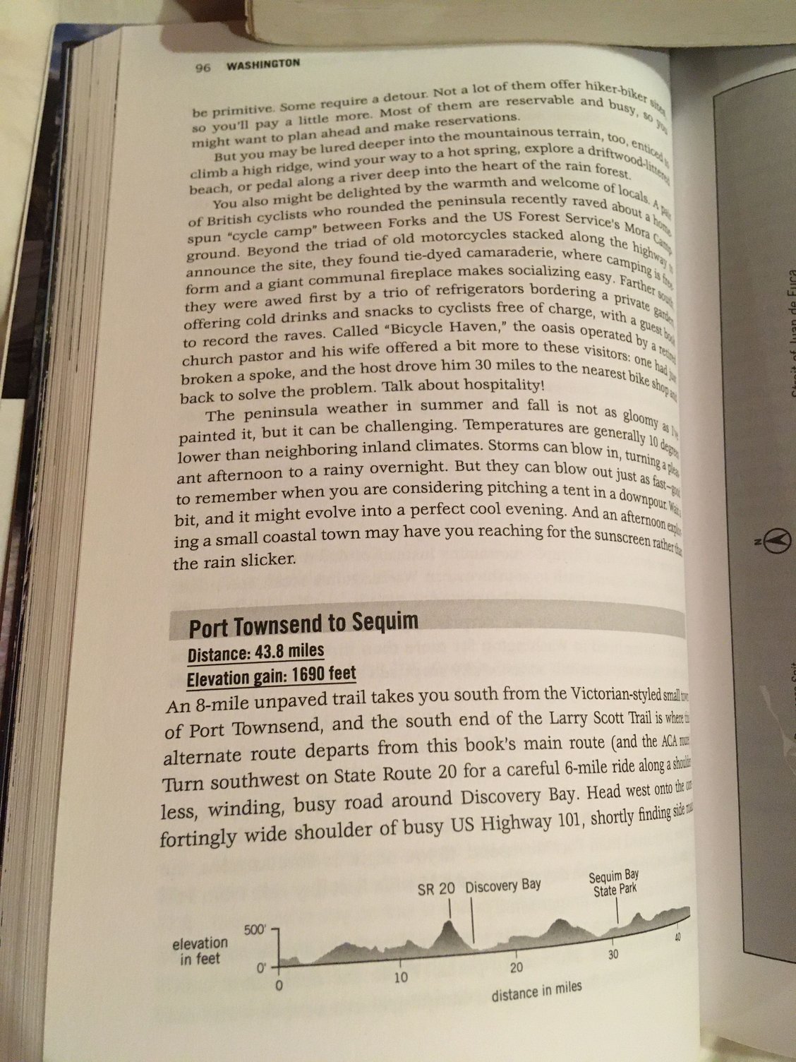
Query for anyone familiar with this general area.
I want to travel South from VC to Seattle and spend a few days there, then get the ferry West and cycle around the Olympic Peninsula.
The ACA Route (Dark Blue, No 1) has me going South and misses Seattle entirely, so I was thinking, should I head South (Red No 2) thru Marysville/Everett etc, or follow the AVA route and then take the ferry into Seattle, then backtrack and ferry back out- then start around the Peninsula?
So in a nutshell- head South via the islands or more inland via Marysville/Everett etc?
Thanks for any advice guys.
Once I get these Routes more fleshed out I'll keep posting them here to see what people think if that's ok?


 12-02-24 | 11:54 PM
#186
Thread Starter
Junior Member
Joined: Aug 2024
Posts: 101
Likes: 10
Bikes: 2018 Giant Talon 3 XL
AH no..! I forgot about that as I've got so many research Tabs open on my browser- it got lost..!
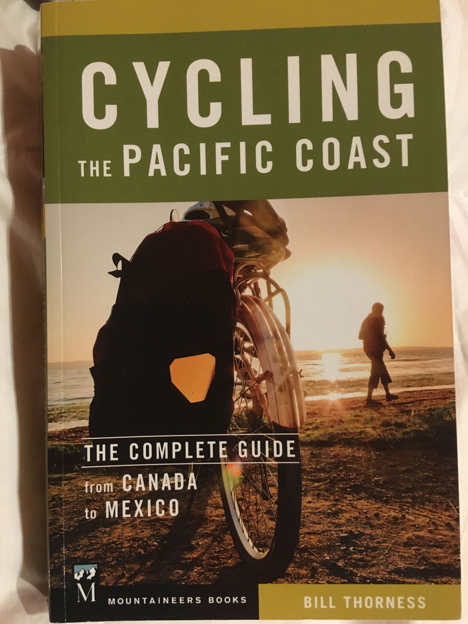
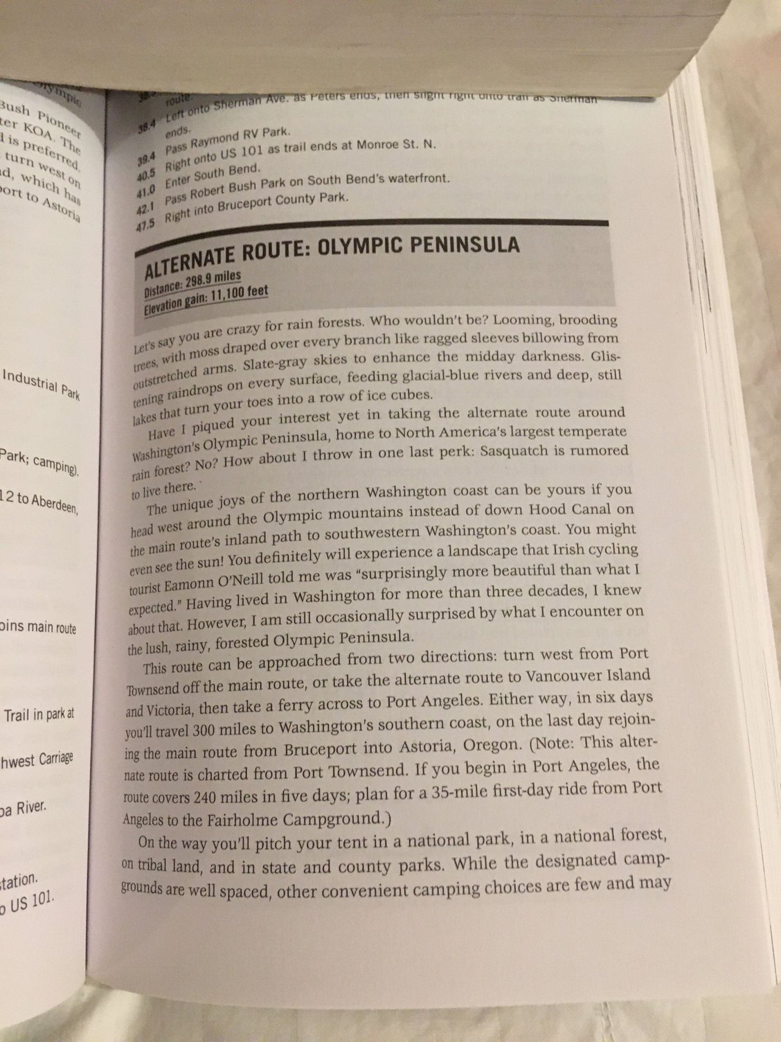
Thanks very much for the kind offer but I'll just order it myself mate- it looks extremely useful tbh and if anything will be good to read along the way during long lonely nights in the tent haha..!!!
Also- thanks for taking the time to take photos of those pages- really appreciate that..!!!
I'll order this today.
==ORDERED!==
Last edited by meshcarver; 12-03-24 at 02:18 AM.
12-03-24 | 07:16 AM
#187
Senior Member
Joined: Jul 2010
Posts: 13,929
Likes: 1,243
From: Montreal Canada
If you have the aca route , will you want to add the weight of the book as well?
I guess when you start putting all your things together in panniers and seeing how much it all weighs, that may be the deciding time.
Dumb question, and if you've already ordered the physical book perhaps too late, but is there a digital version of the book?
Have you thought of taking a tablet or whatever for entertainment purposes? I personally enjoyed having my small tablet on a multi month trip, nice to read and watch stuff sometimes, but again, you have to decide on whats important vs weight.
12-03-24 | 02:00 PM
#188
Senior Member


Joined: Aug 2010
Posts: 12,760
Likes: 2,118
From: Madison, WI
Bikes: 1961 Ideor, 1966 Perfekt 3 Speed AB Hub, 1994 Bridgestone MB-6, 2006 Airnimal Joey, 2009 Thorn Sherpa, 2013 Thorn Nomad MkII, 2015 VO Pass Hunter, 2017 Lynskey Backroad, 2017 Raleigh Gran Prix, 1980s Bianchi Mixte on a trainer. Others are now gone.
Another amateur question- these Waypoints are from the ACA GPX data.
Why are they here? As far as I can tell there's no real reason to have these four here is there? The Route continues on and they're not on any junctions?
I know I might be missing a trick here but could someone please explain to me the relevance of Waypoints and why these might be placed here guys?
Why are they here? As far as I can tell there's no real reason to have these four here is there? The Route continues on and they're not on any junctions?
I know I might be missing a trick here but could someone please explain to me the relevance of Waypoints and why these might be placed here guys?
12-03-24 | 02:40 PM
#189
Punk Rock Lives

Joined: Feb 2002
Posts: 3,424
Likes: 96
From: Throughout the west in a van, on my bike, and in the forest
Bikes: Long Haul Trucker with BRIFTERS!
Bah...screw maps, mapbooks, phone guides and GPS suggestions. Get a GENERAL idea of where you want to ride. When ya get there, go with the flow and listen to local bikers, motorcyclists, bike shops, and truck stop waitresses. My plan for this summer is to do the Sierra/Cascade route for the sixth time.
Thats enough detail for me. Any more detail and i think you are like folks who "climb" Mt. Everest when their sherpas haul them and their REI gear to the top every year.
Thats enough detail for me. Any more detail and i think you are like folks who "climb" Mt. Everest when their sherpas haul them and their REI gear to the top every year.
12-03-24 | 09:18 PM
#190
Thread Starter
Junior Member
Joined: Aug 2024
Posts: 101
Likes: 10
Bikes: 2018 Giant Talon 3 XL
djb Aye, already ordered it mate- cheers anyway. I may take it with me or use it as ref before I go to refine the Route. I'll just be taking my phone with me I think- don't have a tablet..!
Tourist in MSN Ah ok- thanks for explaining that- really had me confused them points. I'll have another crack at refining the route in Komoot today.
Roughstuff I'm in agreement (That's precisely how I've done all my trips in the past, cycling and backpacking etc- paper maps or literally nothing), but the reason I want to nail as much as possible in advance this time is I really want to make sure I'm seeing the best possible scenery and sights as I go along. All this prep work makes sense in that light and I know from experience I'll be winging it a hell of a lot when I'm actually boots on the ground aye- some of the best results and interactions come from just stopping and asking locals etc for directions or advice as I go along- I know that.
I'd hate to come back and have people ask "Did you see such and such..? It was just around the corner from where you cycled..! I can't believe you missed that..!"
Honestly- another point is I'm actually enjoying all this planning aswell. I thought it'd be a drag but I'm learning new stuff and it's getting me in the mood for it the closer it comes too.
12-03-24 | 09:51 PM
#191
Thread Starter
Junior Member
Joined: Aug 2024
Posts: 101
Likes: 10
Bikes: 2018 Giant Talon 3 XL
OK- finally got the detour through the Olympic Peninsula added to the first Route GPX. The official ACA route is in red and the new route I added is in the blue area. I still need to dip into Seattle and then back out West to the start of the OP Route but it'll be easy to add in:
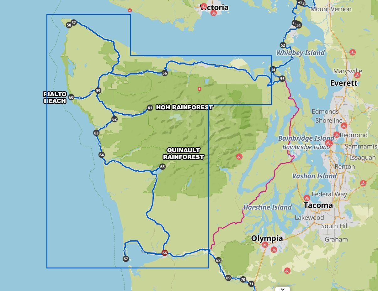
There's a little bit of back tracking along this part but if I want to see places like Hoh and Quinault etc then as far as I can tell it's pretty unavoidable?
There's a little bit of back tracking along this part but if I want to see places like Hoh and Quinault etc then as far as I can tell it's pretty unavoidable?
12-03-24 | 10:55 PM
#192
ignominious poltroon
Joined: Jan 2022
Posts: 6,027
Likes: 5,378
If I remember correctly, I stayed at 56 the first night, 61 the second night and 65 the third night. I think we took a boat across the bay at 67, but it could have been at 66. (This was 1991).
The Hoh and Quinault Rainforests are both within the Olympic National Park boundaries, and both have really nice campsites.
The Hoh and Quinault Rainforests are both within the Olympic National Park boundaries, and both have really nice campsites.
Last edited by Polaris OBark; 12-04-24 at 12:19 AM.
12-04-24 | 02:52 AM
#194
aka Timi
Joined: Feb 2009
Posts: 3,611
Likes: 327
From: Gothenburg, Sweden
Bikes: Bianchi Lupo & Bianchi Volpe Disc: touring. Bianchi Volpe: commuting
Bah...screw maps, mapbooks, phone guides and GPS suggestions. Get a GENERAL idea of where you want to ride. When ya get there, go with the flow and listen to local bikers, motorcyclists, bike shops, and truck stop waitresses. My plan for this summer is to do the Sierra/Cascade route for the sixth time.
Thats enough detail for me. Any more detail and i think you are like folks who "climb" Mt. Everest when their sherpas haul them and their REI gear to the top every year.
Thats enough detail for me. Any more detail and i think you are like folks who "climb" Mt. Everest when their sherpas haul them and their REI gear to the top every year.
There has obviously been a technology shift since paper map and compass, so I also understand people using these digital tools to plan everything out in detail.
Personally I’m more old school ”just go with the flow”, but Komoot in particular has led me onto beautiful paths I would not have otherwise found.
I avoid looking at elevation maps, streetview, heat maps etc, preferring to take the road as it comes with wonder and surprise.
We’re all different ✌️
Last edited by imi; 12-04-24 at 03:56 AM.
12-04-24 | 04:47 AM
#195
Thread Starter
Junior Member
Joined: Aug 2024
Posts: 101
Likes: 10
Bikes: 2018 Giant Talon 3 XL
Aye man, same here as I say.
That India cycle trip I done was essentially unplannable anyway lol- I just kept the sea on my right and made it up as I went along. The Europe trip was with paper maps as I went along- the depth of planning a month before was: "I want to see Belgium, Germany, Austria, Slovenia and Italy" and off I went.
I ended up seeing a few other countries too..!
Maybe hard to believe but I've only had a mobile phone for a few years too- I put it off a long as I could as am not a fan. It's proven to be really useful though- but yeah, I basically steer away from tech solutions.
In this case though it'll be the first time planning with all these tools- and ironic as in a way it's the first trip it's not actually beneficial in a way- like you say "Keep the sea on your right!".
But I do want to make sure I see as much of the sights in the most pleasant way possible- and this allows me to prep for that which is honestly great.
12-04-24 | 06:28 AM
#196
Senior Member
Joined: Aug 2010
Posts: 12,760
Likes: 2,118
From: Madison, WI
Bikes: 1961 Ideor, 1966 Perfekt 3 Speed AB Hub, 1994 Bridgestone MB-6, 2006 Airnimal Joey, 2009 Thorn Sherpa, 2013 Thorn Nomad MkII, 2015 VO Pass Hunter, 2017 Lynskey Backroad, 2017 Raleigh Gran Prix, 1980s Bianchi Mixte on a trainer. Others are now gone.
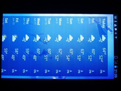
My trip last summer was the first time I have actually used a cell phone in a foreign country with a functional cell phone plan. That said, I think the only time I used it was for weather forecasts or to check e-mail. When not in use, it was off.
I am sure there is better cell phone coverage on this route now than a decade ago, there were two of us with different phone plans. Sometimes mine worked, sometimes my touring partner had a phone that worked. About a quarter of the time, neither worked. Once when neither phone worked, I made a call using my smartphone with restaurant wifi. And once we needed to make a phone call and we actually found a pay phone, remember those?
There have been more frequent forest fires after I did the Pacific Coast route, so you might need to check daily just to see if there are any fires further along the route that you need to worry about. I do not know if there is a "best" web site to check. This might be the best one?
https://www.airnow.gov/wildfires/
I thought the book I had on this route had benefit, it helped here and there telling us bits of info that was useful at the time.
When backpacking, I will be much more careful about weight. I have cut the spine of a book with a utility knife to only carry the pertinent pages for my trip. But bike touring, I do not mind some additional weight, the weight is on my tires, not on my feet. I do not carry canned food or a glass wine bottle on a backpacking trip, but have carried both on a bike trip.
I had great weather when I was there, you can't beat this:
 12-04-24 | 01:22 PM
#197
Senior Member
Joined: Mar 2009
Posts: 6,638
Likes: 1,070
From: Oregon
I know you have mostly settled on a route down to the California border, but I will throw out a couple of suggestions anyway.
My wife and I rode the Pacific Coast Route, and had many trips in the Puget Sound, San Juan Islands, gulf Islands, and Vancouver Island areas.
We started the PCR heading north from Vancouver, BC to Lund and then came back Canadian Hwy 101 to Powell River to take a ferry across to Vancouver Island. We then headed south to Victoria, BC. It is a beautiful city. Then take the ferry across to Port Angeles, Washington which puts you back on route. This may require a few more days, but it is well worth it.
The true PCR starts in Lund, BC

Heading into Victoria

I would also suggest taking your time going through the Redwood forests in northern California. The "Avenue of the Giants road" is a great part of the route. There is a lot of info/maps on the web about the area.
These are the small trees, and not much light gets to the forest floor.

Have a great trip, and don't forget your rain gear!
My wife and I rode the Pacific Coast Route, and had many trips in the Puget Sound, San Juan Islands, gulf Islands, and Vancouver Island areas.
We started the PCR heading north from Vancouver, BC to Lund and then came back Canadian Hwy 101 to Powell River to take a ferry across to Vancouver Island. We then headed south to Victoria, BC. It is a beautiful city. Then take the ferry across to Port Angeles, Washington which puts you back on route. This may require a few more days, but it is well worth it.
The true PCR starts in Lund, BC
Heading into Victoria
I would also suggest taking your time going through the Redwood forests in northern California. The "Avenue of the Giants road" is a great part of the route. There is a lot of info/maps on the web about the area.
These are the small trees, and not much light gets to the forest floor.
Have a great trip, and don't forget your rain gear!
Last edited by Doug64; 12-04-24 at 04:23 PM.
12-04-24 | 10:22 PM
#198
Thread Starter
Junior Member
Joined: Aug 2024
Posts: 101
Likes: 10
Bikes: 2018 Giant Talon 3 XL
Thanks very much for that extra info guys- I'll be taking it onboard and will consider all options..!
I'll definitely be stopping to see the big trees- essential..!!! Really looking forwards to that in particular..!
I'll definitely be stopping to see the big trees- essential..!!! Really looking forwards to that in particular..!
12-05-24 | 07:12 AM
#199
Senior Member
Joined: Jul 2010
Posts: 13,929
Likes: 1,243
From: Montreal Canada
Do really take the time to see the giant redwood trees areas. As a Canadian who grew up doing wilderness stuff, you can't imagine how the scale is these trees are just so much bigger than any normal "big" trees, it will be even more amazing for someone from the UK.
12-06-24 | 10:13 PM
#200
Thread Starter
Junior Member
Joined: Aug 2024
Posts: 101
Likes: 10
Bikes: 2018 Giant Talon 3 XL
Another Komoot/Garmin question.
I'm still refining the Route for the GPS, but how do I "mark" all the campsites along the way so that they'll appear in the GPS?
Do I need to do anything or will they be in the GPS by default? I don't want to "Add To Route" as they'll all add up and I might not used some of them- I just want to make sure that they'll be visible when I'm using the GPS.
I've ticked on Campsites here, but will that translate over to the Garmin or can I toggle campsites to be visible on the Garmin itself?