


Best "Paper" Map Options
 02-21-17 | 07:17 PM
#1
Thread Starter
Senior Member
Joined: Jun 2016
Posts: 806
Likes: 0
From: S/W U.S.
Bikes: 2016 Novara - Safari
Best "Paper" Map Options
While I see that electronic devices and maps have their place, right now I'm interested in paper map options.
From what I've seen so far, the "Adventure Cycling" maps look tops. I really like that they are very durable and waterproof.
This presentation is pretty convincing. Who here uses these, and how do you like them? What alternative or additional maps would you recommend?
From what I've seen so far, the "Adventure Cycling" maps look tops. I really like that they are very durable and waterproof.
This presentation is pretty convincing. Who here uses these, and how do you like them? What alternative or additional maps would you recommend?
Last edited by AdvXtrm; 02-21-17 at 07:23 PM.
 02-21-17 | 07:39 PM
#2
Hooked on Touring


Joined: Mar 2004
Posts: 3,021
Likes: 355
From: Wyoming
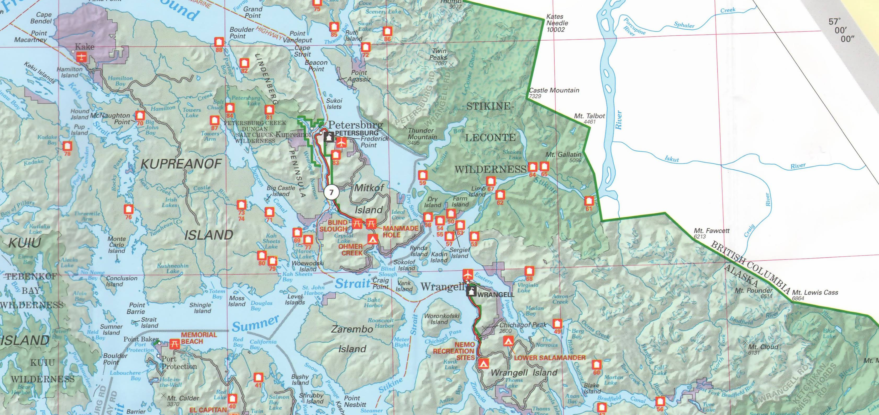
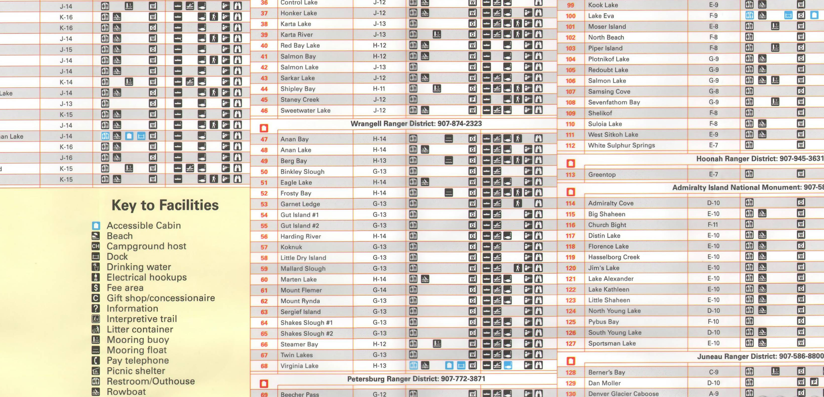
US Forest Service maps are the bomb.
Most of them are now plastic and cost about $10 per.
These maps are done at a scale of 1" = 2 miles and give great detail.
Most also have contours plus detailed road layout.
They are perfect if you plan to get off your bike and explore.
And, of course, they are usually in lovely mountain scenery.
This website has a few dozen in the West scanned - PaperMapsOnline:
Shoshone National Forest North - Paper Maps Online
You can see the spectacular Wapiti Canyon east of Yellowstone on the Shoshone N.F.
(Sometimes their homepage doesn't load correctly - but if you google by name and state, it will)
02-21-17 | 07:44 PM
#3
bicycle tourist

Joined: Dec 2007
Posts: 2,625
Likes: 464
From: Austin, Texas, USA
Bikes: Trek 520, Lightfoot Ranger, Trek 4500
What I like about Adventure Cycling maps in addition to their durability, is the quick index of services in various towns.
The Great Divide Mountain Bike Route seems to have some alternate services listed even slightly off the route. The other Adventure Cycling maps I've used less so (Southern Tier, Trans-America). I do go back to an electronic form (Google Maps) to do my research there. However, without that I also still like the traditional paper highway maps including free maps that a number of states provide at Welcome Centers and similar places.
The Great Divide Mountain Bike Route seems to have some alternate services listed even slightly off the route. The other Adventure Cycling maps I've used less so (Southern Tier, Trans-America). I do go back to an electronic form (Google Maps) to do my research there. However, without that I also still like the traditional paper highway maps including free maps that a number of states provide at Welcome Centers and similar places.
02-21-17 | 07:52 PM
#4

Senior Member
Joined: Sep 2008
Posts: 488
Likes: 16
From: Ashfield, Mass.
My first experience with ACA maps was this past Sept. on the Northern Tier. I used the Sect. 3 map for the first three days and then departed from the route when it became apparent that the feared truck traffic from the fracking boom was no longer an issue (the boom peaked and has now quieted) and Rt. 2 led me due east, as opposed to a 100 mile southward dogleg had I stayed with ACA's route, on a day with 20-30 mile tailwinds followed by a second one with 30-40 mile winds.
However the ACA map led me to a free first night's sleep in the town-owned Griffin Park in Chinook, MT and, given that fact, I figured had already paid for itself. Details like that mean that I am buying Sects. 1 & 2 for next year's trip from Anacortes, WA to Havre, MT and expect I'll more than likely stick with the entire route this time and get more than their purchase price in good tips.
Did get back onto the ACA map (Sect. 5) at the very end of last Sept's ride when I followed the Paul Bunyan trail from Bemidji to Walker, MN. Beautiful trail, perfect antidote to the congestion of Rt. 2, and confirmation that ACA does a nice job scouting out their routes for the most bicycle friendly options for getting from point A to point B.
 02-21-17 | 08:04 PM
#6

Joined: Jul 2007
Posts: 3,423
Likes: 55
From: Chapin, SC
Bikes: all steel stable: surly world troller, paris sport fixed, fuji ss
I've reduced my tours down to zero paper maps. Any paper map that's useful beyond the the standard-electronic I'll just take a photo of it. Paper seems like carrying a stone-tablet. Sure it works, but it's a wasteful use of effort, time, and resources.
02-21-17 | 08:05 PM
#7
Hooked on Touring
Joined: Mar 2004
Posts: 3,021
Likes: 355
From: Wyoming
Except when there is no reception or your device crashes.
02-21-17 | 08:10 PM
#8
Joined: Jul 2007
Posts: 3,423
Likes: 55
From: Chapin, SC
Bikes: all steel stable: surly world troller, paris sport fixed, fuji ss
My phone is waterproof. Has never crashed. Images on the phone don't need reception. I have had paper maps disintegrate in the rain.
PLUS--> The ultimate irony is that you can read virtually every thing that's on the maps in the video posted by the OP!
PLUS--> The ultimate irony is that you can read virtually every thing that's on the maps in the video posted by the OP!
Last edited by BigAura; 02-21-17 at 10:07 PM.
02-21-17 | 08:14 PM
#9
Senior Member
Joined: Sep 2008
Posts: 488
Likes: 16
From: Ashfield, Mass.
Like the guy who stopped in front of my house looking lost. When I asked him if he needed help he said he'd lost reception on his iphone and wasn't sure where he was and how much farther he needed to go (he was deep into a pretty brutally long day at that point). I went to my car and pulled out a map of the state. Pointed to his location on the map. Pointed to his destination on the map and said it might come in handy since reception was spotted in this hilly part of the state.
02-21-17 | 08:43 PM
#10
Joined: Jul 2007
Posts: 3,423
Likes: 55
From: Chapin, SC
Bikes: all steel stable: surly world troller, paris sport fixed, fuji ss
Like the guy who stopped in front of my house looking lost. When I asked him if he needed help he said he'd lost reception on his iphone and wasn't sure where he was and how much farther he needed to go (he was deep into a pretty brutally long day at that point). I went to my car and pulled out a map of the state. Pointed to his location on the map. Pointed to his destination on the map and said it might come in handy since reception was spotted in this hilly part of the state.
Last edited by BigAura; 02-21-17 at 09:15 PM.
02-21-17 | 09:05 PM
#12

Senior Member
Joined: Apr 2015
Posts: 8,206
Likes: 86
From: Metro Detroit/AA
Bikes: 2016 Novara Mazama
For an anecdote the other way, paper maps were cool on my last tour, until I started hitting areas where routes were renumbered. Internet on my phone came in really handy at that point.
02-21-17 | 09:18 PM
#13
Joined: Jul 2007
Posts: 3,423
Likes: 55
From: Chapin, SC
Bikes: all steel stable: surly world troller, paris sport fixed, fuji ss
02-21-17 | 09:45 PM
#14
Joined: Jul 2007
Posts: 3,423
Likes: 55
From: Chapin, SC
Bikes: all steel stable: surly world troller, paris sport fixed, fuji ss
US Forest Service maps are the bomb.
Most of them are now plastic and cost about $10 per.
These maps are done at a scale of 1" = 2 miles and give great detail.
Most also have contours plus detailed road layout.
They are perfect if you plan to get off your bike and explore.
And, of course, they are usually in lovely mountain scenery.
This website has a few dozen in the West scanned - PaperMapsOnline:
Shoshone National Forest North - Paper Maps Online
You can see the spectacular Wapiti Canyon east of Yellowstone on the Shoshone N.F.
(Sometimes their homepage doesn't load correctly - but if you google by name and state, it will)
Most of them are now plastic and cost about $10 per.
These maps are done at a scale of 1" = 2 miles and give great detail.
Most also have contours plus detailed road layout.
They are perfect if you plan to get off your bike and explore.
And, of course, they are usually in lovely mountain scenery.
This website has a few dozen in the West scanned - PaperMapsOnline:
Shoshone National Forest North - Paper Maps Online
You can see the spectacular Wapiti Canyon east of Yellowstone on the Shoshone N.F.
(Sometimes their homepage doesn't load correctly - but if you google by name and state, it will)
this is lighter (and disposable OR NOT):
*btw: those are quick examples but with thought, could be easily organized.
Last edited by BigAura; 02-21-17 at 09:49 PM.
02-22-17 | 12:57 AM
#15
Thread Starter
Senior Member
Joined: Jun 2016
Posts: 806
Likes: 0
From: S/W U.S.
Bikes: 2016 Novara - Safari
I have an android phone, and I'm familiar with navigation apps, and even have some that work offline and such as mentioned, but again, that wasn't my question or why I made this thread. I may end up posting a separate one regarding nav apps though. I know I'll be using my phone at times as needed, even while having paper maps, but I'd like to have paper maps, so as not to be using the phone as much, and needing to depend on it. Maybe with some time experience that may change, but right now, that's where I'm at.
02-22-17 | 12:58 AM
#16
Thread Starter
Senior Member
Joined: Jun 2016
Posts: 806
Likes: 0
From: S/W U.S.
Bikes: 2016 Novara - Safari
US Forest Service maps are the bomb.
Most of them are now plastic and cost about $10 per.
These maps are done at a scale of 1" = 2 miles and give great detail.
Most also have contours plus detailed road layout.
They are perfect if you plan to get off your bike and explore.
And, of course, they are usually in lovely mountain scenery.
This website has a few dozen in the West scanned - PaperMapsOnline:
Shoshone National Forest North - Paper Maps Online
You can see the spectacular Wapiti Canyon east of Yellowstone on the Shoshone N.F.
(Sometimes their homepage doesn't load correctly - but if you google by name and state, it will)
Most of them are now plastic and cost about $10 per.
These maps are done at a scale of 1" = 2 miles and give great detail.
Most also have contours plus detailed road layout.
They are perfect if you plan to get off your bike and explore.
And, of course, they are usually in lovely mountain scenery.
This website has a few dozen in the West scanned - PaperMapsOnline:
Shoshone National Forest North - Paper Maps Online
You can see the spectacular Wapiti Canyon east of Yellowstone on the Shoshone N.F.
(Sometimes their homepage doesn't load correctly - but if you google by name and state, it will)
02-22-17 | 01:22 AM
#17
Thread Starter
Senior Member
Joined: Jun 2016
Posts: 806
Likes: 0
From: S/W U.S.
Bikes: 2016 Novara - Safari
Can someone tell be which kinds of roads/trails on these maps I should consider acceptable to ride on and those to avoid? I'm looking at some of the Forest Service maps, and so far I see nothing bicycle specific mentioned. I do see some OHV roads, but I'm not even sure exactly what those are, and if those should be considered as good or not.
02-22-17 | 01:46 AM
#18

In Real Life
Joined: Jan 2003
Posts: 52,159
Likes: 772
From: Down under down under
Bikes: Lots
I pick up maps at tourist info centres. You can find tourist info centres all over the place. 
__________________
Rowan
My fave photo threads on BF
Century A Month Facebook Group
Machka's Website
Photo Gallery
Rowan
My fave photo threads on BF
Century A Month Facebook Group
Machka's Website
Photo Gallery
02-22-17 | 02:02 AM
#19
Thread Starter
Senior Member
Joined: Jun 2016
Posts: 806
Likes: 0
From: S/W U.S.
Bikes: 2016 Novara - Safari
When you've never done any of this stuff before, and you don't personally know anyone who has, there is a lot you have to learn. I've learned a lot, but still lots left. I'm going to start out with some more local tours, then plan out further ones once I have some experience. Like I said, I've had so much to learn, not just about bicycles, but the touring specific aspects, and since I won't be doing any credit-card touring, only self-sufficient camping, and trying to spend as little money as I can at the same time. This means a lot more learning and gathering of supplies is needed. But! I'm finally almost ready for my first tour! Woohoo!!
02-22-17 | 03:25 AM
#20
In Real Life
Joined: Jan 2003
Posts: 52,159
Likes: 772
From: Down under down under
Bikes: Lots
I'll def check out any tourist and info centers I'm near thanks. Right now I'm still learning what some basic terms mean. I've heard talk of "rail trails" around here since I joined, and I just learned what those are! lol
When you've never done any of this stuff before, and you don't personally know anyone who has, there is a lot you have to learn. I've learned a lot, but still lots left. I'm going to start out with some more local tours, then plan out further ones once I have some experience. Like I said, I've had so much to learn, not just about bicycles, but the touring specific aspects, and since I won't be doing any credit-card touring, only self-sufficient camping, and trying to spend as little money as I can at the same time. This means a lot more learning and gathering of supplies is needed. But! I'm finally almost ready for my first tour! Woohoo!!
When you've never done any of this stuff before, and you don't personally know anyone who has, there is a lot you have to learn. I've learned a lot, but still lots left. I'm going to start out with some more local tours, then plan out further ones once I have some experience. Like I said, I've had so much to learn, not just about bicycles, but the touring specific aspects, and since I won't be doing any credit-card touring, only self-sufficient camping, and trying to spend as little money as I can at the same time. This means a lot more learning and gathering of supplies is needed. But! I'm finally almost ready for my first tour! Woohoo!!
Here in Australia there's a tourist info office (visitor centre) in just about every town. They are less common in the US, but this might give you some idea what to look for ...
https://en.wikipedia.org/wiki/Welcom..._United_States
__________________
Rowan
My fave photo threads on BF
Century A Month Facebook Group
Machka's Website
Photo Gallery
Rowan
My fave photo threads on BF
Century A Month Facebook Group
Machka's Website
Photo Gallery
02-22-17 | 09:42 AM
#21
Senior Member
Joined: Dec 2007
Posts: 895
Likes: 10
From: columbus, ohio
Bikes: Soma Saga, 1980 Schwinn Voyageur 11.8, New Albion Privateer
I have used the ACA maps and they are great. I also have used DeLorme gazetteer maps (photocopied the pages I needed so as not to carry the whole book). I find the issue with electronic alone is you cannot get a large enough area with the detail you need. In my opinion there is no substitute for paper maps despite what some may say.
02-22-17 | 10:04 AM
#22
Senior Member
Joined: Dec 2010
Posts: 9,684
Likes: 2,602
From: northern Deep South
Bikes: Fuji Touring, Novara Randonee
ACA maps are great if you're on an ACA route. Even there, I like to supplement them with state highway maps from a tourist information center when entering a new state. IMHO they are the best tool for the job, for the reasons given previously.
In addition, the roads I like to ride on the most are the low-traffic back roads, the ones that disappear on electronic maps (google, Garmin, etc.) when I get to a scale that I can see where they go. It is pretty aggravating to need to get somewhere at the end of a long day's ride and find out the road you've been traveling for the last half hour is a dead end.
In addition, the roads I like to ride on the most are the low-traffic back roads, the ones that disappear on electronic maps (google, Garmin, etc.) when I get to a scale that I can see where they go. It is pretty aggravating to need to get somewhere at the end of a long day's ride and find out the road you've been traveling for the last half hour is a dead end.
02-22-17 | 11:09 AM
#23

Senior Member
Joined: Aug 2005
Posts: 4,080
Likes: 391
Not sure if DeLorme Gazetteer is available for all states or where you plan to ride but they sure come in handy, and they're so much lighter than the stone tablets we used before.
02-22-17 | 11:32 AM
#24
Upgrading my engine
Joined: Aug 2004
Posts: 6,218
Likes: 0
From: Alamogordo
It depends where you're going. Some DOT websites have decent maps. Some don't.
I carry small paper cards and put my own maps on there. They are a combination of RideWithGPS maps with elevation profiles and Google Maps that I print out. Basically they're a quick reference that can answer any basic questions I have. My routes are all planned in advance, which may not be your cup of tea.
I could do an imperfect reroute based on those maps if **** hit the fan. They're good to have, but obviously Google Maps on my phone would be more detailed.
02-22-17 | 11:59 AM
#25
Member
Joined: Dec 2004
Posts: 2,080
Likes: 170
Nothing beats a paper map for general route planning across a region. You can't get the same breadth of feel for a region with a phone or a tablet, IMO. Also, detailed paper maps for some places have a wealth of information which tools like google maps are presently lacking. Having said that, my phone has been helpful at times when I've been on my bike, including reaching an isolated location yesterday, and also a few weeks ago on some rural roads I was biking on in Mexico. As for ACA maps, I recall encountering a cyclist in the Rockies who was strictly following an ACA route. I made a suggestion to him about something nearby worth seeing. But he had no other maps and therefore was afraid to venture off the ACA route because he had no idea where he was once he left the narrow band shown on the ACA map.