


Pacific Coast Route
 09-19-24 | 11:35 PM
#101
Thread Starter
Junior Member
Joined: Aug 2024
Posts: 101
Likes: 10
Bikes: 2018 Giant Talon 3 XL
Hi all- sorry to reheat this but wondering if any of you could give some advice?
As all the cycle trips I've done upto now have been with paper maps, I'm really considering the same for this one- esp as it SEEMS to be very "simple" in terms of roads, mainly it's just the the 101 and then State Highway 1 as far as I can tell.
I've currently got 3 paper Rand McNally State maps for Wash, Oregon and Cali and they seem fine for me to follow- I know the scale doesn't allow for all the little roads and details but if this is as simple as the 101 and 1 then should they suffice?
Would you guys definitely recommend I bring a cycle nav computer with me or it just isn't necessary for this trip?
I'm pretty confident with paper map reading and honestly prefer it as it gives a sense of adventure too- not know about gradients/climbs coming up either.
I've been watching Mat Ryder recently and am really enjoying his videos on his current trip (Gears my mind up for the trip)- the Trans Am. There's a bit were he visits the ACA and they talk about how in using cycle nav computers/digital, that they're in some way losing a part of the magic of paper maps:
Ah, the clip starts at 28:40. For some reason I can't get the timestamp to come through here..!
The guys point about having your head down and going from A to B and then all of a sudden you're in a city resonates.
I know it's not that cut and dried but the sentiment is there.
By using paper and having to knock on doors/stop and ask people for directions etc I really did experience so many amazing encounters when I was cycling through Europe and India- and arguably they wouldn't have occurred if I'd been using digital.
I'm not knocking digital- far from it, and I know how important it can be in emergencies etc etc- it's just that given the opportunity I'd rather not use it for this trip, but I would appreciate it if anyone could tell me if that's a big mistake..!
I don't even know whether it's worth getting the ACA Maps for the PCBR either or just relying on these State Maps I have, Rand McNally. I'll post a few images to show the "resolution" of them/the road network shown.
You can clearly see the 101 and the milage distances between points etc- I'm just wondering if I'd also need something a bit more scaled to show a lot smaller roads etc:
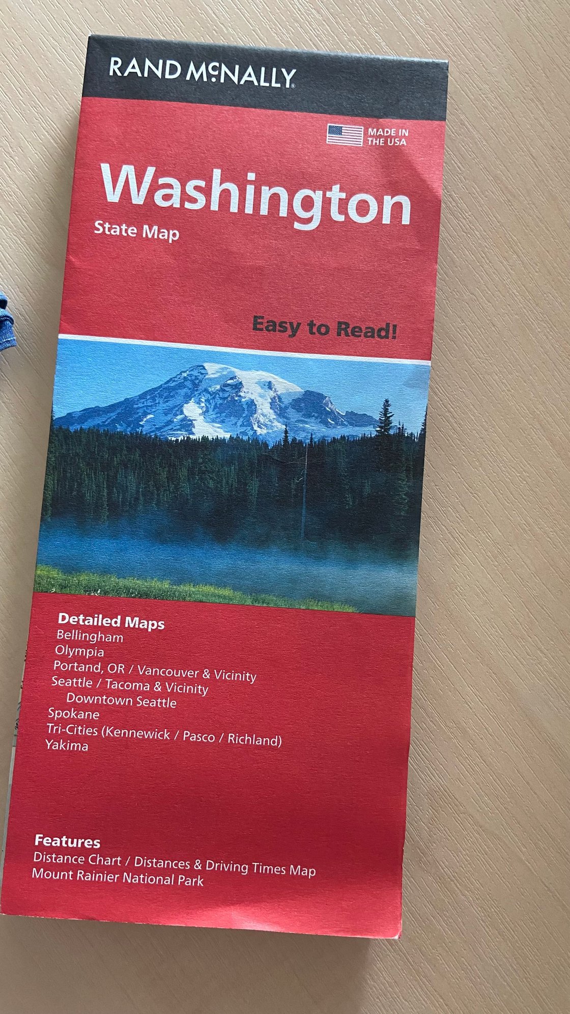
COVER
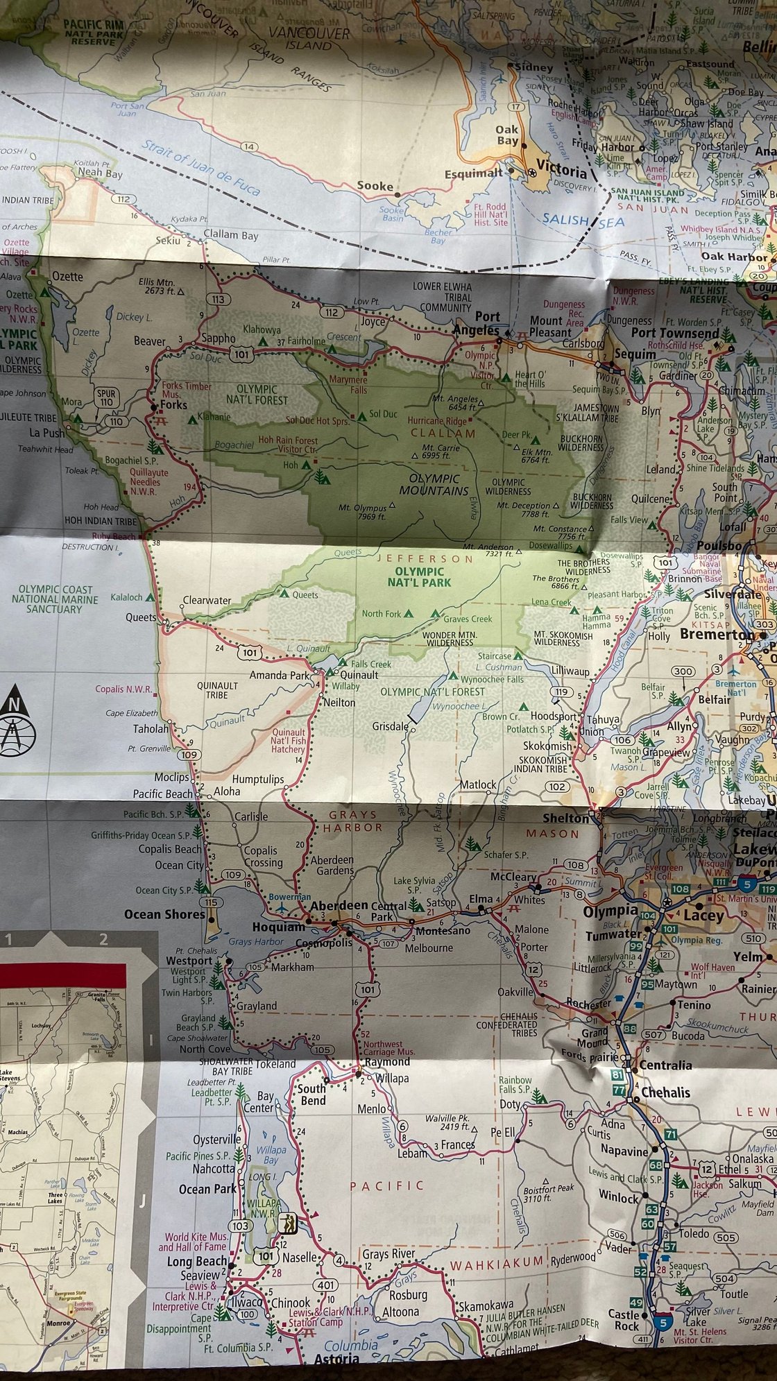
OLYMPIC SECTION
Ok- thanks again for your time guys and I look forwards to any sage advice, esp from people who've already done this route or parts of it.
For my getting back into shape, I haven't missed a day training yet- am still doing a steady 10 miles per morning on the cycling machine (Average about 75-80 rpms) then 10 lengths in the pool with 100 revolution kicks under water every 2 lengths and my knee is holding up fine. I'll be adding another 5 miles every month until I get to 40.
As all the cycle trips I've done upto now have been with paper maps, I'm really considering the same for this one- esp as it SEEMS to be very "simple" in terms of roads, mainly it's just the the 101 and then State Highway 1 as far as I can tell.
I've currently got 3 paper Rand McNally State maps for Wash, Oregon and Cali and they seem fine for me to follow- I know the scale doesn't allow for all the little roads and details but if this is as simple as the 101 and 1 then should they suffice?
Would you guys definitely recommend I bring a cycle nav computer with me or it just isn't necessary for this trip?
I'm pretty confident with paper map reading and honestly prefer it as it gives a sense of adventure too- not know about gradients/climbs coming up either.
I've been watching Mat Ryder recently and am really enjoying his videos on his current trip (Gears my mind up for the trip)- the Trans Am. There's a bit were he visits the ACA and they talk about how in using cycle nav computers/digital, that they're in some way losing a part of the magic of paper maps:
Ah, the clip starts at 28:40. For some reason I can't get the timestamp to come through here..!
The guys point about having your head down and going from A to B and then all of a sudden you're in a city resonates.
I know it's not that cut and dried but the sentiment is there.
By using paper and having to knock on doors/stop and ask people for directions etc I really did experience so many amazing encounters when I was cycling through Europe and India- and arguably they wouldn't have occurred if I'd been using digital.
I'm not knocking digital- far from it, and I know how important it can be in emergencies etc etc- it's just that given the opportunity I'd rather not use it for this trip, but I would appreciate it if anyone could tell me if that's a big mistake..!
I don't even know whether it's worth getting the ACA Maps for the PCBR either or just relying on these State Maps I have, Rand McNally. I'll post a few images to show the "resolution" of them/the road network shown.
You can clearly see the 101 and the milage distances between points etc- I'm just wondering if I'd also need something a bit more scaled to show a lot smaller roads etc:
COVER
OLYMPIC SECTION
Ok- thanks again for your time guys and I look forwards to any sage advice, esp from people who've already done this route or parts of it.
For my getting back into shape, I haven't missed a day training yet- am still doing a steady 10 miles per morning on the cycling machine (Average about 75-80 rpms) then 10 lengths in the pool with 100 revolution kicks under water every 2 lengths and my knee is holding up fine. I'll be adding another 5 miles every month until I get to 40.
Last edited by meshcarver; 09-19-24 at 11:41 PM.
 09-20-24 | 03:08 AM
#102
bicycle tourist

Joined: Dec 2007
Posts: 2,626
Likes: 464
From: Austin, Texas, USA
Bikes: Trek 520, Lightfoot Ranger, Trek 4500
As far as maps go. While I did ride it with paper maps + the Bicycling the Pacific Coast book on my first trip in 1998 - I did have some tricky sections including (a) getting out/,through Vancouver, San Francisco and LA bypass. Your Rand McNally maps just won't have the details and you would likely have to augment.
My suggestions; for the Oregon section, the State bike map is fine, similarly for northern CA it is also fine. However:
1) If you go with maps, the Adventure Cycling maps are worth it. They will get you a better route including several more tricky sections across Vancouver, San Francisco and Los Angeles.
2) The book is dated but otherwise could be OK resource but I would favor the maps.
3) While I've had a bike computer as an odometer for most all my touring - I more recently experimented as a navigation device. Having at least distance is helpful on navigation on paper maps. Having a device note turn by turn points can be a handy thing you get used to but also not strictly necessary in my opinion
4) I would struggle some with only the Rand McNally state maps (and I've done the coast multiple times in different trips)
09-20-24 | 05:11 AM
#103
Senior Member


Joined: Aug 2010
Posts: 12,737
Likes: 2,107
From: Madison, WI
Bikes: 1961 Ideor, 1966 Perfekt 3 Speed AB Hub, 1994 Bridgestone MB-6, 2006 Airnimal Joey, 2009 Thorn Sherpa, 2013 Thorn Nomad MkII, 2015 VO Pass Hunter, 2017 Lynskey Backroad, 2017 Raleigh Gran Prix, 1980s Bianchi Mixte on a trainer. Others are now gone.
As a retired geological engineer that worked with maps every day of my professional career, I have a bias, as I always want the best in location information.
That said, I use a general recreation GPS, not a cycling specific GPS. That allows me to use it for backpacking trips, canoe or kayak trips, etc. Runs on AA batteries, but I can charge NiMH rechargeable AA batteries in the GPS with a work-around and a mini (not micro or C) USB cable while I am riding with a USB charger powered by my dynohub.
For example on my last tour, I had a long day where I knew that it was over 80 miles to my next campground. I did not make a reservation, and was concerned that the campground would fill before I got there. The route I was following started to have lots of extra turns and extra distance added to the route compared to if I just quit following the route and looked for a more direct major road, which is what I did when I got to the closed sign, below:

If I had a paper map instead, it would not have given me the detail for navigating in cities.
Also I sometimes use the ability of the GPS to pick my routing for me.
That said, there are times that the paper map gives me a route that looks a lot better than the routing that my GPS suggests, I also use a paper map for that reason. The paper map is on the top of my handlebar bag. And if a paper map suggests a more direct route, I often take it instead.
That said, I use a general recreation GPS, not a cycling specific GPS. That allows me to use it for backpacking trips, canoe or kayak trips, etc. Runs on AA batteries, but I can charge NiMH rechargeable AA batteries in the GPS with a work-around and a mini (not micro or C) USB cable while I am riding with a USB charger powered by my dynohub.
For example on my last tour, I had a long day where I knew that it was over 80 miles to my next campground. I did not make a reservation, and was concerned that the campground would fill before I got there. The route I was following started to have lots of extra turns and extra distance added to the route compared to if I just quit following the route and looked for a more direct major road, which is what I did when I got to the closed sign, below:
If I had a paper map instead, it would not have given me the detail for navigating in cities.
Also I sometimes use the ability of the GPS to pick my routing for me.
That said, there are times that the paper map gives me a route that looks a lot better than the routing that my GPS suggests, I also use a paper map for that reason. The paper map is on the top of my handlebar bag. And if a paper map suggests a more direct route, I often take it instead.
09-20-24 | 05:33 AM
#104

Senior Member
Joined: Mar 2024
Posts: 1,948
Likes: 784
From: San Diego
Bikes: Columbine, Lynskey GR300, Paramount Track Bike, Colnago Super (4), Santana Tandems (1995 & 2007), Gary Fisher Piranha (retired), Bianchi Track Bike, a couple of Honda mountain bikes
In my experience, a dedicated cycling computer doesn't work as well as Ridewithgps, Google Maps and Apple Maps. One does have to be careful with these as sometimes they make "unproductive" suggestions, but they would be a great combination with paper maps.
09-20-24 | 05:50 AM
#105
Senior Member
Joined: Jul 2010
Posts: 13,912
Likes: 1,242
From: Montreal Canada
don't forget that there are a number of offline map systems that you can have as a backup on your phone or tablet. In tricky urban settings, I have even used google maps on my phone, but just listening to the voice command (so screen off) with my phone in a small toptube barbag. I have no interest in having my phone in a holder on my bars, not for battery use, not for risk of damage or whatever.
I do have a Garmin bike gps now, but for a majority of this ride, you shouldnt have to be looking at a screen to not miss turns, but the times you do, its fairly easy to check your phone to be sure where you are.
I suspect though that even some rudimentary on paper notes will be fine for a lot of the trip.
Getting sorted out for the more urban, confusing sections also makes sense.
Having any sort of electronic device for navigation will mean having a battery bank as backup for charging stuff, including your phone, at places where there are not outlets, or where you can't safely have eyes on things charging.
The nice thing is that battery banks of 10 or 20,000 milliamps, are super common now and affordable. All you'll need is the North American plug in bits to attach your various charging cables to.
Obvious advantage in having them all having the same type of usb plug, all newer stuff generally has the type whatever one now, Apple stuff excepted. (I mention this just to keep in mind when chosing devices, to try to have them all with the same type charging plug/port thingees)
09-20-24 | 08:02 AM
#106
bicycle tourist
Joined: Dec 2007
Posts: 2,626
Likes: 464
From: Austin, Texas, USA
Bikes: Trek 520, Lightfoot Ranger, Trek 4500
don't forget that there are a number of offline map systems that you can have as a backup on your phone or tablet. In tricky urban settings, I have even used google maps on my phone, but just listening to the voice command (so screen off) with my phone in a small toptube barbag.
1. MAPS.ME or the older version as Organic Maps. This is an offline map. The cycling instructions are junk and I don't use it for offline routing. Instead, what I've found helpful is a quick offline check of "where am I?" In a confusing urban setting you will likely have a cell signal as well but if you are either saving data or in a place without cell signal it can sometimes be helpful to sort out your location.
In both cases I don't have the phone on continuously. Instead it is always turned off but then on demand I'll turn it on to check my offline map.
2. iOverlander. While the primary audience is more towards overland vehicles and motorcyclists - this can be a useful app to find see camp sites or services. There tends to be a community that keeps things up to date. You can get an idea of the type of info by looking at the web site and then think of having it on your phone. It works better when there is a cell signal though you can still get info w/o maps since the database has been downloaded.
09-20-24 | 08:56 AM
#107
Senior Member
Joined: Jul 2010
Posts: 13,912
Likes: 1,242
From: Montreal Canada
And you may have already asked, but it will be worth looking into American cell phone / mobile plans that hopefully you can quickly get set up on your phone when you get into a larger US town or whatever.
You could ask over at the CTC bike forums and maybe get some reliable, recent Brit experiences of what companies they used and what coverage is available from different companies.
Also if there are any hiccups with UK / European phones and yank systems.
You could ask over at the CTC bike forums and maybe get some reliable, recent Brit experiences of what companies they used and what coverage is available from different companies.
Also if there are any hiccups with UK / European phones and yank systems.
09-20-24 | 10:28 AM
#108
bicycle tourist
Joined: Dec 2007
Posts: 2,626
Likes: 464
From: Austin, Texas, USA
Bikes: Trek 520, Lightfoot Ranger, Trek 4500
- I found US cell signals don't stretch too far into Canada
- I also found that getting from the Vancouver Airport to the US border took me just a little planning to avoid bridges/tunnels not open to bicycles
So this is a good spot to look up the route in advance and write out a few notes in finding your way. An offline map as mentioned before can also sanity check that you are traveling on the route.
The US is slightly different than many countries with a lot of phones using a "locked" service where the phone and a cell service plan are combined. However, if your phone uses SIM cards you will be able to find SIM cards sold for what are named as "unlocked" phones or otherwise basic SIM phones I see elsewhere in the world (most of which use the same variation of frequency bands).
Once in the US, if your phone uses SIM cards not far off your route, you will be able to find such SIM cards in Bellingham, WA. For example, I expect both Walmart and Best Buy to carry them. The other thing I've also been able to do is order via Amazon and have it delivered to an Amazon locker along the way (or order a SIM card in advance in the UK and activate once you are in the US).
I'll let you research phone alternatives but there are ~4 national networks and some of the SIM providers resell their service on those national networks. However, one pretty basic example I use on a backup phone is something like this: https://speedtalkmobile.com/top-value-unlimited-plans/ Coverage has some gaps compared with some other networks but cost is also not much.
09-20-24 | 11:40 AM
#109
Senior Member
Joined: Aug 2010
Posts: 12,737
Likes: 2,107
From: Madison, WI
Bikes: 1961 Ideor, 1966 Perfekt 3 Speed AB Hub, 1994 Bridgestone MB-6, 2006 Airnimal Joey, 2009 Thorn Sherpa, 2013 Thorn Nomad MkII, 2015 VO Pass Hunter, 2017 Lynskey Backroad, 2017 Raleigh Gran Prix, 1980s Bianchi Mixte on a trainer. Others are now gone.
And you may have already asked, but it will be worth looking into American cell phone / mobile plans that hopefully you can quickly get set up on your phone when you get into a larger US town or whatever.
You could ask over at the CTC bike forums and maybe get some reliable, recent Brit experiences of what companies they used and what coverage is available from different companies.
Also if there are any hiccups with UK / European phones and yank systems.
You could ask over at the CTC bike forums and maybe get some reliable, recent Brit experiences of what companies they used and what coverage is available from different companies.
Also if there are any hiccups with UK / European phones and yank systems.
https://www.puretalk.com
09-20-24 | 01:10 PM
#110
Senior Member
Joined: Mar 2024
Posts: 1,948
Likes: 784
From: San Diego
Bikes: Columbine, Lynskey GR300, Paramount Track Bike, Colnago Super (4), Santana Tandems (1995 & 2007), Gary Fisher Piranha (retired), Bianchi Track Bike, a couple of Honda mountain bikes
For my regular cell phone service I use Pure Talk, they operate on the AT&T network. If you can get by with a data only plan, that is pretty cheap at $10 a month, cancel when you want. I think I also had to pay for the sim card initially. The $10/mn data only plan is listed under Tablet Plans. I put the sim card for a $10 tablet plan into a spare Android phone, it works.
https://www.puretalk.com
https://www.puretalk.com
Related but slightly different suggestion:
- I found US cell signals don't stretch too far into Canada
- I also found that getting from the Vancouver Airport to the US border took me just a little planning to avoid bridges/tunnels not open to bicycles
So this is a good spot to look up the route in advance and write out a few notes in finding your way. An offline map as mentioned before can also sanity check that you are traveling on the route.
The US is slightly different than many countries with a lot of phones using a "locked" service where the phone and a cell service plan are combined. However, if your phone uses SIM cards you will be able to find SIM cards sold for what are named as "unlocked" phones or otherwise basic SIM phones I see elsewhere in the world (most of which use the same variation of frequency bands).
Once in the US, if your phone uses SIM cards not far off your route, you will be able to find such SIM cards in Bellingham, WA. For example, I expect both Walmart and Best Buy to carry them. The other thing I've also been able to do is order via Amazon and have it delivered to an Amazon locker along the way (or order a SIM card in advance in the UK and activate once you are in the US).
I'll let you research phone alternatives but there are ~4 national networks and some of the SIM providers resell their service on those national networks. However, one pretty basic example I use on a backup phone is something like this: https://speedtalkmobile.com/top-value-unlimited-plans/ Coverage has some gaps compared with some other networks but cost is also not much.
10-12-24 | 01:37 AM
#111
Thread Starter
Junior Member
Joined: Aug 2024
Posts: 101
Likes: 10
Bikes: 2018 Giant Talon 3 XL
Hi again guys and gals- am starting to research about Camping along this route and came across this helpful site:
gobikecamping
I'm trying to get my head around the camping in the US as there seems to be many different types of site and it's a little confusing.
I won't be able to book ahead at all as I don't know where I'll be and when, so I'll be trying to get to these Hiker/Biker sites as much as possible as I THINK you can just turn up at them- is that right?
JUST found this aswell- maybe helpful to anyone looking for the same information:
Hiker Biker Campsites in the US
10-12-24 | 05:25 AM
#112
Senior Member
Joined: Aug 2010
Posts: 12,737
Likes: 2,107
From: Madison, WI
Bikes: 1961 Ideor, 1966 Perfekt 3 Speed AB Hub, 1994 Bridgestone MB-6, 2006 Airnimal Joey, 2009 Thorn Sherpa, 2013 Thorn Nomad MkII, 2015 VO Pass Hunter, 2017 Lynskey Backroad, 2017 Raleigh Gran Prix, 1980s Bianchi Mixte on a trainer. Others are now gone.
Hi again guys and gals- am starting to research about Camping along this route and came across this helpful site:
gobikecamping
I'm trying to get my head around the camping in the US as there seems to be many different types of site and it's a little confusing.
I won't be able to book ahead at all as I don't know where I'll be and when, so I'll be trying to get to these Hiker/Biker sites as much as possible as I THINK you can just turn up at them- is that right?
JUST found this aswell- maybe helpful to anyone looking for the same information:
Hiker Biker Campsites in the US
gobikecamping
I'm trying to get my head around the camping in the US as there seems to be many different types of site and it's a little confusing.
I won't be able to book ahead at all as I don't know where I'll be and when, so I'll be trying to get to these Hiker/Biker sites as much as possible as I THINK you can just turn up at them- is that right?
JUST found this aswell- maybe helpful to anyone looking for the same information:
Hiker Biker Campsites in the US
I was there 10 years ago, so my information is quite dated, but these were my observations at that time:
Southt to North Pacific Coast Highway Concerns
11-01-24 | 10:22 PM
#114
Senior Member
Joined: Mar 2009
Posts: 6,633
Likes: 1,063
From: Oregon
Several Oregon campgrounds' Hiker/Biker campsites are now equipped with kiosks that have lockers with secure charging stations for your electronics, and more.
Hiker /biker area
Hiker /biker area
Last edited by Doug64; 11-01-24 at 10:26 PM.
11-01-24 | 11:29 PM
#115
Broken neck Ken
Joined: Oct 2008
Posts: 5,221
Likes: 3,516
From: Portland, OR
Bikes: Trek Domane SL6 Gen 3, Soma Fog Cutter, Detroit Bikes Sparrow FG, Trek Mt Track XCNimbus MUni
I live in the Portland area, and have ridden the Washington and Oregon sections extensively. Some random thoughts.
The Olympic peninsula is one of my favorite places ever. Remote, yes - don't skip any store because it's probably the only one. Possibly a rainy slog, yes. Rain makes stuff beautiful. So many shades of green!
Given your comfort with maps, and the general rule to keep the ocean on your right, go for it. But have a phone with maps downloaded in rwgps stowed when you need to figure out where you actually are, and where services are. That's means battery bank and charge cables. Riding with gps is faster, but you mostly don't know where you are. Don't expect full cell coverage.
Astoria is quaint, has decent brewpubs. Worth a zero day imo. That bridge crossing is memorable.
If you want to have mostly hot meals without cooking, your daily distance is going to be driven by where food can be found. Personally I'd at least be able to boil water.
There are some narrow-shoulder short-sightline segments. Some tunnels where you push a button to activate the bike-warning lights then race through in terror. Some bridges where you might opt for the sidewalk despite the lane being legal. The good news is, the motorists are mostly accustomed to bikes.
Muir woods North of SF is a must see imo. Not just the tourist boardwalk, but a full day adventure. Leave your bike somewhere and take the Marin County Stage (bus) from the golden gate bridge up to the first stop past the park entrance. Enter the woods at a trailhead there, hike down to the visitors center for lunch, then back up for the return bus. There's a fancy restaurant up at the bus stop where you can kill a couple hours waiting for the infrequent bus. It's spectacular.
As others have said, the Oregon cost is not flat. It also provides some of the most spectacular ocean views you'll see anywhere.

 11-02-24 | 09:40 AM
#117
ignominious poltroon
Joined: Jan 2022
Posts: 6,027
Likes: 5,377
That's good. That bridge was arguably the most scary thing on the ride.
The narrow lane would entice riders up onto that cement riser. A logging truck driver told me every year someone would fall off it while riding and get injured or killed.
The narrow lane would entice riders up onto that cement riser. A logging truck driver told me every year someone would fall off it while riding and get injured or killed.
11-03-24 | 02:31 AM
#118
Thread Starter
Junior Member
Joined: Aug 2024
Posts: 101
Likes: 10
Bikes: 2018 Giant Talon 3 XL
Hi guys- wow, this is all massively appreciated.
There's so much useful information and advice building up it's really, really mind blowing tbh.
Honestly I can't thank you guys enough to take the time to explain this route further and give advice on sections and must see's etc.
Those must do's downtube42 are REALLY appreciated. I'm trying myself to research the route to see parts like that but obviously it's MUCH better coming from someone who knows these areas.
On that- if ANYONE has any specific things/areas to see as recommendations then PLEASE PLEASE let me know here- it's EXACTLY the kind of info I'm looking for now and am making notes on the maps as I get it.
For instance- I'm planning to see Yosemite National Park so am considering hiring a car when I get to the parallel of it and stashing the bike somewhere safe like a hostel/motel- that kind of thing.
I'll be buying a SIM that'll basically cover me as much as possible for the entire route and that is good for 3 months, as that's the amount of time I want to take to do the route with some substantial stops on the way to explore/see sights/hike etc. My ESTA gives me 90 days in the US so I want to use it all.
I've marked on my maps where the Hiker/Biker Sites are too and ref'd them against the websites to make sure too.
I MIGHT take a gas cannister with small stove/cooking pot as well- not sure yet. If I could eat in local places along the entirety of the route I'd much rather do that as I want to try that gorgeous American food..!
Ok guys- thanks again, all this info goes in and really helps me get a handle on what to expect and how to plan for it etc.
It's priceless.
Last edited by meshcarver; 11-03-24 at 03:27 AM.
11-03-24 | 06:13 AM
#119
Senior Member
Joined: Jul 2010
Posts: 13,912
Likes: 1,242
From: Montreal Canada
I'd highly recommend the small stove and pot idea. I've always enjoyed the potion to make tea, coffee in morning, and the ability to heat up basic meals or make pasta or soup.
In my opinion, totally worth carrying, especially on a longer trip.
Just be sure the stove part uses common propane type canisters available in outdoor stores etc. Shouldn't be an issue.
In my opinion, totally worth carrying, especially on a longer trip.
Just be sure the stove part uses common propane type canisters available in outdoor stores etc. Shouldn't be an issue.
11-03-24 | 06:43 AM
#121
Senior Member
Joined: Jul 2010
Posts: 13,912
Likes: 1,242
From: Montreal Canada
And it's always good to have a simple backup meal in a pannier bottom if for some reason you can't easily get to a store before getting to a campground. Some pasta, a can of tuna, dry package of soup, whatever to make a simple meal that's better than no meal at all.
11-03-24 | 06:44 AM
#122
Senior Member
Joined: Aug 2010
Posts: 12,737
Likes: 2,107
From: Madison, WI
Bikes: 1961 Ideor, 1966 Perfekt 3 Speed AB Hub, 1994 Bridgestone MB-6, 2006 Airnimal Joey, 2009 Thorn Sherpa, 2013 Thorn Nomad MkII, 2015 VO Pass Hunter, 2017 Lynskey Backroad, 2017 Raleigh Gran Prix, 1980s Bianchi Mixte on a trainer. Others are now gone.
...
On that- if ANYONE has any specific things/areas to see as recommendations then PLEASE PLEASE let me know here- it's EXACTLY the kind of info I'm looking for now and am making notes on the maps as I get it.
...
I'll be buying a SIM that'll basically cover me as much as possible for the entire route and that is good for 3 months, ...
...
I MIGHT take a gas cannister with small stove/cooking pot as well- not sure yet. If I could eat in local places along the entirety of the route I'd much rather do that as I want to try that gorgeous American food..!
....
I assume you plan to double check to make sure your phone has the correct bands for the phone plan that you plan to get here. Some of the phone companies on their website have a way that you can enter data on your phone and it will tell you if it is compatible. A couple weeks ago I bought a new "international" Samsung phone, the product listing on Amazon specifically told me which USA carriers would and would not work with the phone I bought. I live in USA and wanted to make sure my phone would work with my existing plan.
Yes, bring the small stove. A cooking pot, utensils, etc. I did the route 10 years ago, maybe things are different now, but we did not see a lot of places to eat along the route on a regular basis. I think we bought groceries every two or three days. But we planned to eat in the campsite for most meals, with the option to eat out whenever we saw a convenient restaurant. Having a couple cans of soup in your pannier as backup meals is a good idea. If you shop at a grocery store called Safeway, you may need to ask for a membership card (it is free) to get the sale prices. You will see lots of Safeway stores. Once you are here and on the route, you could ask other bikers what stores you should look for to buy canisters.
Do not forget to bring a cork screw.
11-03-24 | 06:52 AM
#124
Senior Member
Joined: Jul 2010
Posts: 13,912
Likes: 1,242
From: Montreal Canada
I don't have specific memories of store availability, but it's easy t to just look at what towns are along the way to where you plan to sleep, sometimes you have to carry supper and breakfast stuff half a day, but not a huge deal.
When I did this trip, Bill Clinton was president and John Major was the UK pm ......so my memories are way out of date.
When I did this trip, Bill Clinton was president and John Major was the UK pm ......so my memories are way out of date.
11-03-24 | 10:49 AM
#125
Member

Joined: Dec 2004
Posts: 2,080
Likes: 170
About 20 miles after you cross into California from Oregon, you will enter Jedediah Smith State Park. As I recall, heading south in Jedediah Smith State Park, you are initially in second growth redwood forest. But you will soon enter an impressive old growth redwood forest and it is extraordinary. I was cycling with a European friend and he was blown away when he first saw an old growth redwood forest. You will be in and near many other old growth redwood forest areas in Redwood National Park and California state parks as you continue south.
Lots of interesting things to see and do along the California coast depending on your interests. The funky Santa Cruz boardwalk, Hearst Castle in San Simeon at the south end of Big Sur, gardens in Santa Barbara. If you happen to be in San Luis Obispo on a Thursday evening, there is a great outdoor farmer's market well-known for its BBQ.