


View Poll Results: What is your preferred method of navigating a route?
Digital maps only (GPS, RWGPS, Google Maps, etc.)


19
44.19%
Paper Maps only (ACA, AAA, etc.)


2
4.65%
Both Digital and Paper maps


19
44.19%
Maps, I don't need no stinkin maps!


3
6.98%
Voters: 43. You may not vote on this poll
Favorite Form of Navigation Aid

 12-08-25 | 05:28 PM
#77

Full Member
Joined: Jul 2023
Posts: 456
Likes: 271
From: Montr�al
Bikes: Hardrock touring bike
Digital requires electricity. Has anyone here managed to be electrically self-sufficient while still relying on non-paper maps ?
What do you do when you're far from an outlet for several days at a time ? Or put differently, how many days are you good for digitally ?
What do you do when you're far from an outlet for several days at a time ? Or put differently, how many days are you good for digitally ?
12-08-25 | 05:38 PM
#78
Senior Member


Joined: Jul 2007
Posts: 8,597
Likes: 3,526
From: South shore, L.I., NY
Bikes: Trek Emonda SL7, Cannondale Topstone, Miyata City Liner, Specialized Chisel, Specialized Epic Evo
12-08-25 | 06:32 PM
#79
Senior Member
Joined: Mar 2010
Posts: 2,616
Likes: 2,198
For regular touring, I use my Edge 1050, which has 20 hours fully enabled and 60 hours in battery saver mode. For more extended, more remote tours, my Edge 1040 Solar lasts around 100 hours. I usually carry a Nitecore NB20000 as a backup, and it can charge numerous devices a couple of times. For those who are really committed to complete long-term power independence, a generator hub would be a reasonable option.
12-08-25 | 06:51 PM
#80
Senior Member
Joined: Jul 2010
Posts: 13,903
Likes: 1,241
From: Montreal Canada
I've had a battery bank that could charge it at least a few times, and battery banks seem to be the best bang for the buck for recharging.
Prices have gone down, and the last one I bought , I think a 10,000 milliamp one, recharges much much faster than older ones we have had in the family. I would have to look up the specs again, but the new one (which is a lot smaller and lighter than the older ones also) charges fully in 2 hours tops, whereas my old one took something like 6 or 8 hrs
a generator hub would be nice, but they mean a lot more money involved, whereas its pretty easy to have multiple battery banks at reasonable prices now, that charge fast and come in all kinds of millamp sizes, 5000, 10000, 20000.
Basically you look at the millamp size of your doohickys battery, lets say 3000ma and a 10,000 bank will charge it three times more or less.
so not that hard to keep using ones devices, especially with access to plugs usually during a day or at a campground or whatever.
and thats not even touching on the newer solar supplemented gps units out there, and which will certainly improve and improve.
12-08-25 | 07:37 PM
#81
Senior Member

Joined: Aug 2010
Posts: 12,717
Likes: 2,104
From: Madison, WI
Bikes: 1961 Ideor, 1966 Perfekt 3 Speed AB Hub, 1994 Bridgestone MB-6, 2006 Airnimal Joey, 2009 Thorn Sherpa, 2013 Thorn Nomad MkII, 2015 VO Pass Hunter, 2017 Lynskey Backroad, 2017 Raleigh Gran Prix, 1980s Bianchi Mixte on a trainer. Others are now gone.
Run a dynohub to charge batteries. Phone is only on when I am making a call, checking weather forecast (usually twice a day), or checking e-mail. Skip down to the section on Electrics in the first post for more detail.
Bike Tour near Lake Ontario and part of Erie Canal - June 2024
12-09-25 | 12:31 AM
#82
Senior Member

Joined: Feb 2004
Posts: 3,812
Likes: 434
From: Thailand..........currently Nakhon Ricefield, moving to the beach soon.
Bikes: inferior steel....alas....noodly aluminium assploded
Admitting a weakness is culturally verboten, "I dunno" is unheard of. The answer to how far to xxx is invariably 2km. Mentally draining to have completed 150 km in mountains, nearing your target town, and be told 2 km over and over for 20 km.
Then you run into locals that have never left their village in 50 years, and some who don't know their settlement even has a name.
Don't forget the other 58 non-han minorities with their own language and script, many whose only Chinese is "I don't speak Chinese."
12-09-25 | 12:39 AM
#83
Senior Member
Joined: Feb 2004
Posts: 3,812
Likes: 434
From: Thailand..........currently Nakhon Ricefield, moving to the beach soon.
Bikes: inferior steel....alas....noodly aluminium assploded
Friend of mine was driving from CA to TX, didn't want to try out those newfangled paper maps that were all the rage amongst the younguns.
He did it the old-fashioned way, carried a globe on the center console. It showed the interstate highways, so good enough.
He did it the old-fashioned way, carried a globe on the center console. It showed the interstate highways, so good enough.
12-09-25 | 10:34 AM
#84
bicycle tourist
Joined: Dec 2007
Posts: 2,625
Likes: 464
From: Austin, Texas, USA
Bikes: Trek 520, Lightfoot Ranger, Trek 4500
I often have two basic Garmin GPS so I can record my route so ~four days but even if I needed to cross a gap with more days because most likely my navigation consists of following the only road. The five roads mentioned above also have mileposts pretty regularly.
If I want to know where I am, I can briefly turn on a cell phone and with offline map and the phone's GPS determine that though often knowing I am mile 360 of the Dalton Highway and Atigun summit is at mile 244 is sufficient...
12-09-25 | 11:43 AM
#85
Senior Member
Joined: Aug 2010
Posts: 12,717
Likes: 2,104
From: Madison, WI
Bikes: 1961 Ideor, 1966 Perfekt 3 Speed AB Hub, 1994 Bridgestone MB-6, 2006 Airnimal Joey, 2009 Thorn Sherpa, 2013 Thorn Nomad MkII, 2015 VO Pass Hunter, 2017 Lynskey Backroad, 2017 Raleigh Gran Prix, 1980s Bianchi Mixte on a trainer. Others are now gone.
I built up my own touring bikes from parts. Thus, for me a dynohub did not cost much, the only cost was the hub, minus the cost of the non-dynohub that I otherwise would have bought. I usually build my own wheels. But for most people, buying a dynohub would cost much more, the dynohub, the rim, the spokes and nipples, and maybe a wheel build fee.
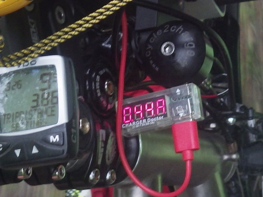
Dynohub puts out alternating current with very variable voltage depending on speed. You need a way to convert AC power to 5 volt DC power if you are using USB devices or powerbanks that are charged by USB. I initially used a Sinewave Revolution, a good charger with outstanding waterproofness. But in summer 2022 I bought a Cycle2Charge USB charger that puts out roughly 50 percent more electric power than the Sinewave.
I think that Happy Feet that used to post on this forum and Gauvins that still occasionally does instead use solar power, I think that they have both operated self sustaind with just solar. I think Gauvins used to use a dynohub, but switched to solar.
But a big part of this is being very frugal with your electricity, only use what you need, when you need it. Phones in daytime will need a lot of backlight to be readable, and a lot of backlight is a lot of power. GPS units on the other hand do not need any backlight at all in daytime. With my Garmin 64 I often need a bit of backlight in early morning or evening when it is still quite light out but the sun is low, but during daytime I keep the backlight off. I run my GPS so that the screen is always on (so I do not have to keep taking my hand off the bars to push a button to wake up the screen), but with the backlight off, it consumes almost no additional power to keep the screen on.
I assume that I am averaging about 2 watts of power generation when riding on fairly flat ground, more hilly terrain average maybe 1 watt, and in very hilly terrain I get much less. When I first installed the Cycle2Charge, I did some tests, these are the results:
.
- 6.5 mph to get any power at all, below 6.5 it did not turn on.
- 9 mph was about 0.6 amps, or 2.9 watts.
- 11 mph was about 0.8 amps, or 3.9 watts.
- 15 mph was about 1.0 amps, or 4.8 watts.
- 22 mph (shallow downhill, briefly) about 1.25 amps, or 6.1 watts.
Thus, on a good day, I might produce 12 to 15 watt hours of power. But I probably consumed one third of that by running my GPS. And I am using a 44 watt hour powerbank, so at best I am only producing maybe one quarter of the power that my powerbank is capable of holding.
You can buy some really good powerbanks that hold 72 watt hours (I have two of that size, but do not bring them on bike tours) for very little money.
I really think that if your tour is a week long, or if you plan to sleep indoors at least once a week, you are better off just buying some good powerbanks, not trying to generate your own power. Before I started using a dynohub, I always looked for seating in restaurants near outlets to charge batteries. With the high output USB-C chargers, you could get a lot of power into a powerbank, simply by getting lucky by getting a good place to sit in a restaurant to charge up a powerbank.
I would suggest not buying any powerbanks that are 100 or more watt hour capacity, flying restrictions could prevent you from taking that size powerbank on a plane.
But, if you are a power hog, bring your laptop computer with you, want your phone on all day every day, use a rechargeable tall light with humungous Lumens, you might want to just credit card tour so you can charge up everything every night.
A friend of mine bought a really bright taillight for touring, at full brightness on flash, it lasted less than five hours when brand new before the battery was dead. Oops.
I have a meter that can tell me how much power I am getting out of my dynohub, as long as the sun does not shine on the LED display which is not very bright. In the photo, 0.44 amps, I suspect at about 4.9 volts, thus a hair over 2 watts.
Last edited by Tourist in MSN; 12-09-25 at 11:46 AM.
12-09-25 | 04:22 PM
#86
Full Member

Joined: Jul 2017
Posts: 406
Likes: 163
12-10-25 | 12:44 PM
#87
Senior Member
Joined: Feb 2010
Posts: 1,138
Likes: 258
From: NH
.Take this paper vs digital mapping and routing debate. I propose beginning a bike tour in Barcelona and finishing in Toulouse via Andorra. The thought of building a route out of Barcelona along the most popular and efficient bike routes, then across the countryside, ending with entering the core of Toulouse with paper maps and cue sheets, makes absolutely no sense, and the resulting route would be vastly inferior to a digitally built one.
I have a hearing loss. I'd miss many voice directions from GPS while riding. For safety I don't take eyes off the road to check directions, be it from device or paper. I'll stop to check the route. That's why paper works for ME. Not because I'm old & set in my ways or have "entrenched beliefs".
I'm not suggesting you revert back to paper because GPS works well for YOU. But you're making paper mapping sound harder than it really is to others, at least in Europe. France is the easiest country in the world to piece together your own bike route. I've saved every Michelin map from previous trips in France including the sections of your proposed tour starting in Barcelona. I'd just link up the seemingly infinite choice of yellow or white D routes.
The maps fold neatly into a 4"x10" rectangle, a lot wider view than a phone or GPS. That's 30 miles of travel left to right, 13 miles up & down without zooming, scrolling or re-folding at 1/200,000' detail. Newer editions are 1/150,000'. They look as tidy as your unit does when they're tucked into a map viewer. No batteries required. "On your left!" works as good as your electronic bell. I can envision a perfect trip to Toulouse. Here's one map section midway the width of my viewer & how I would choose my route ...

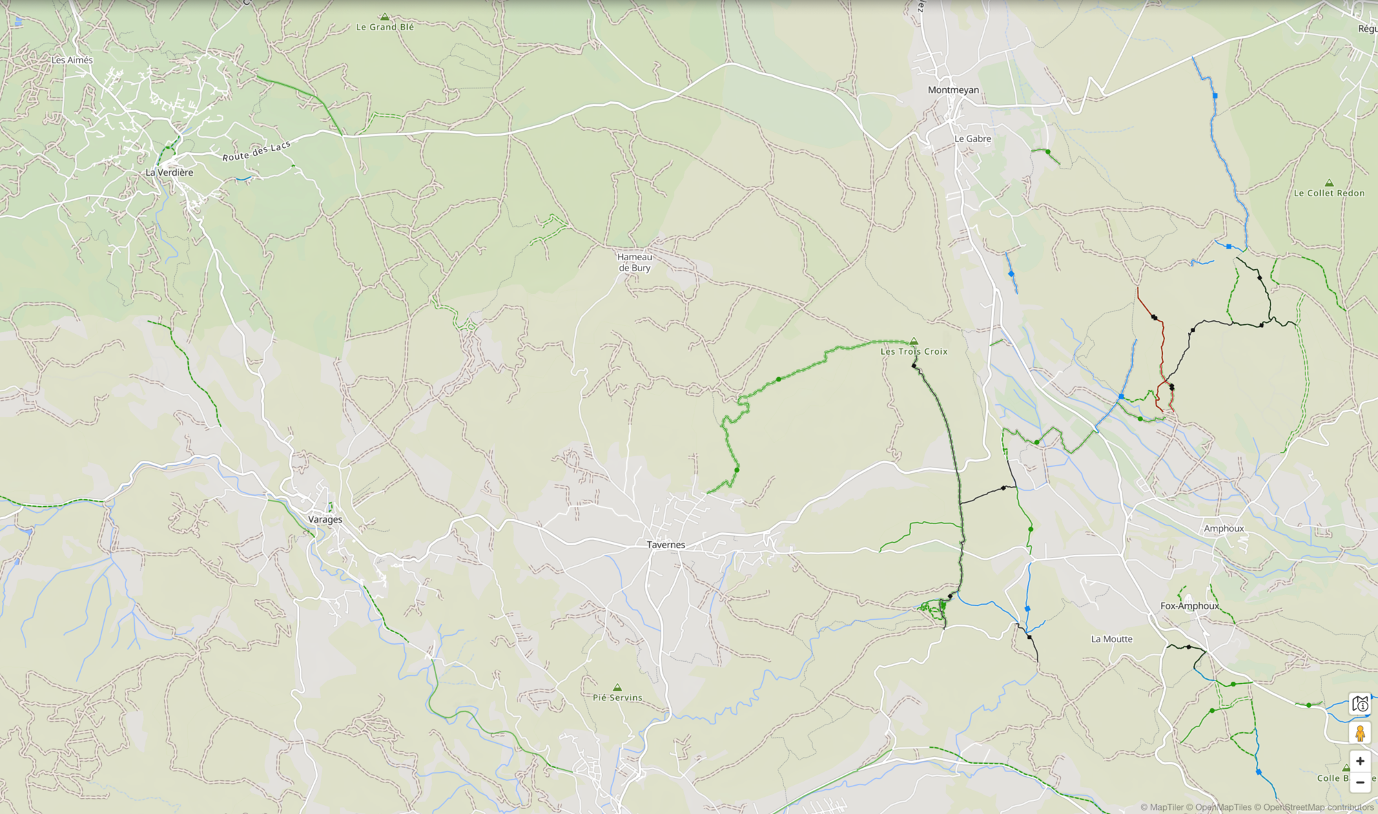
Let's see ... We'll try D-9 & D-30 from Aups to la Verdiere. I see campgrounds (^) indicated on the map at both towns and another at Regusse. Then let's bear left on D-65 and left again at that squiggly D-470 to D-561. Looks beautiful! Let's take that route!...
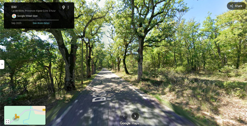
I'd stop at St Martin for coffee and then plan the next segment, continuing on D-561. Rinse & repeat all the way to Toulouse. No need for pre-mapped Euro-Velo routes or bike paths. You can choose your own unique small roads. I'll use my electronic device for city details.
Here I go again arguing about maps with a guy named Atlas!

Last edited by BobG; 12-10-25 at 02:23 PM.
12-10-25 | 04:59 PM
#88
Senior Member
Joined: Mar 2010
Posts: 2,616
Likes: 2,198
Atlas-
I have a hearing loss. I'd miss many voice directions from GPS while riding. For safety I don't take eyes off the road to check directions, be it from device or paper. I'll stop to check the route. That's why paper works for ME. Not because I'm old & set in my ways or have "entrenched beliefs".
I'm not suggesting you revert back to paper because GPS works well for YOU. But you're making paper mapping sound harder than it really is to others, at least in Europe. France is the easiest country in the world to piece together your own bike route. I've saved every Michelin map from previous trips in France including the sections of your proposed tour starting in Barcelona. I'd just link up the seemingly infinite choice of yellow or white D routes.
The maps fold neatly into a 4"x10" rectangle, a lot wider view than a phone or GPS. That's 30 miles of travel left to right, 13 miles up & down without zooming, scrolling or re-folding at 1/200,000' detail. Newer editions are 1/150,000'. They look as tidy as your unit does when they're tucked into a map viewer. No batteries required. "On your left!" works as good as your electronic bell. I can envision a perfect trip to Toulouse. Here's one map section midway the width of my viewer & how I would choose my route ...
Let's see ... We'll try D-9 & D-30 from Aups to la Verdiere. I see campgrounds (^) indicated on the map at both towns and another at Regusse. Then let's bear left on D-65 and left again at that squiggly D-470 to D-561. Looks beautiful! Let's take that route!...
I'd stop at St Martin for coffee and then plan the next segment, continuing on D-561. Rinse & repeat all the way to Toulouse. No need for pre-mapped Euro-Velo routes or bike paths. You can choose your own unique small roads. I'll use my electronic device for city details.
Here I go again arguing about maps with a guy named Atlas!
12-11-25 | 01:35 AM
#89
Senior Member


Joined: Sep 2013
Posts: 1,637
Likes: 1,791
From: Spain
A decent powerbank will do the job. A 20,000mah powerbank charged all my devices (phone, wahoo, lights) for 4 days without needing a top-up. If I were on a longer trip, I would probably take multiple powerbanks. They're not that heavy and don't take up loads of space. 2 x 20000 and 1 x 10000 would do 9-10 days of charging. And in a real emergency, my front light can act as a powerbank if needed (I carry other sources of light, inc a head lamp).
 ))
))Apart that a 20.000mA/h takes 5 days to charge
__________________
https://stefanrohner.exposure.co
https://stefanrohner.exposure.co
12-11-25 | 01:45 AM
#90
Senior Member
Joined: Sep 2013
Posts: 1,637
Likes: 1,791
From: Spain
Atlas-
I have a hearing loss. I'd miss many voice directions from GPS while riding. For safety I don't take eyes off the road to check directions, be it from device or paper. I'll stop to check the route. That's why paper works for ME. Not because I'm old & set in my ways or have "entrenched beliefs".
I'm not suggesting you revert back to paper because GPS works well for YOU. But you're making paper mapping sound harder than it really is to others, at least in Europe. France is the easiest country in the world to piece together your own bike route. I've saved every Michelin map from previous trips in France including the sections of your proposed tour starting in Barcelona. I'd just link up the seemingly infinite choice of yellow or white D routes.
The maps fold neatly into a 4"x10" rectangle, a lot wider view than a phone or GPS. That's 30 miles of travel left to right, 13 miles up & down without zooming, scrolling or re-folding at 1/200,000' detail. Newer editions are 1/150,000'. They look as tidy as your unit does when they're tucked into a map viewer. No batteries required. "On your left!" works as good as your electronic bell. I can envision a perfect trip to Toulouse. Here's one map section midway the width of my viewer & how I would choose my route ...
Let's see ... We'll try D-9 & D-30 from Aups to la Verdiere. I see campgrounds (^) indicated on the map at both towns and another at Regusse. Then let's bear left on D-65 and left again at that squiggly D-470 to D-561. Looks beautiful! Let's take that route!...
I'd stop at St Martin for coffee and then plan the next segment, continuing on D-561. Rinse & repeat all the way to Toulouse. No need for pre-mapped Euro-Velo routes or bike paths. You can choose your own unique small roads. I'll use my electronic device for city details.
Here I go again arguing about maps with a guy named Atlas!
I have a hearing loss. I'd miss many voice directions from GPS while riding. For safety I don't take eyes off the road to check directions, be it from device or paper. I'll stop to check the route. That's why paper works for ME. Not because I'm old & set in my ways or have "entrenched beliefs".
I'm not suggesting you revert back to paper because GPS works well for YOU. But you're making paper mapping sound harder than it really is to others, at least in Europe. France is the easiest country in the world to piece together your own bike route. I've saved every Michelin map from previous trips in France including the sections of your proposed tour starting in Barcelona. I'd just link up the seemingly infinite choice of yellow or white D routes.
The maps fold neatly into a 4"x10" rectangle, a lot wider view than a phone or GPS. That's 30 miles of travel left to right, 13 miles up & down without zooming, scrolling or re-folding at 1/200,000' detail. Newer editions are 1/150,000'. They look as tidy as your unit does when they're tucked into a map viewer. No batteries required. "On your left!" works as good as your electronic bell. I can envision a perfect trip to Toulouse. Here's one map section midway the width of my viewer & how I would choose my route ...
Let's see ... We'll try D-9 & D-30 from Aups to la Verdiere. I see campgrounds (^) indicated on the map at both towns and another at Regusse. Then let's bear left on D-65 and left again at that squiggly D-470 to D-561. Looks beautiful! Let's take that route!...
I'd stop at St Martin for coffee and then plan the next segment, continuing on D-561. Rinse & repeat all the way to Toulouse. No need for pre-mapped Euro-Velo routes or bike paths. You can choose your own unique small roads. I'll use my electronic device for city details.
Here I go again arguing about maps with a guy named Atlas!
__________________
https://stefanrohner.exposure.co
https://stefanrohner.exposure.co
12-11-25 | 02:00 AM
#91
Thread Starter
Senior Member
Joined: Sep 2005
Posts: 628
Likes: 166
From: Tulsa, OK
Bikes: Co-Motion Americano Pinion P18; Co-Motion Americano Rohloff; Thorn Nomad MkII, Robert Beckman Skakkit (FOR SALE), Santana Tandem, ICE Adventure FS
str, While your point about most maps not showing unpaved roads, you are trying to put your desires (no paved roads) onto everyone else by implying every decent map must show that. As BobG indicates previously, if it works for YOU, great. But that doesn't mean EVERYONE wants gravel all the time even though gravel roads tend to offer better photo opportunities.
12-11-25 | 03:33 AM
#92
Senior Member
Joined: Sep 2013
Posts: 1,637
Likes: 1,791
From: Spain
str, While your point about most maps not showing unpaved roads, you are trying to put your desires (no paved roads) onto everyone else by implying every decent map must show that. As BobG indicates previously, if it works for YOU, great. But that doesn't mean EVERYONE wants gravel all the time even though gravel roads tend to offer better photo opportunities.
And yes, of course I can talk ONLY for myself, I think thats obvious.
__________________
https://stefanrohner.exposure.co
https://stefanrohner.exposure.co
12-11-25 | 05:51 AM
#93
Senior Member
Joined: Aug 2010
Posts: 12,717
Likes: 2,104
From: Madison, WI
Bikes: 1961 Ideor, 1966 Perfekt 3 Speed AB Hub, 1994 Bridgestone MB-6, 2006 Airnimal Joey, 2009 Thorn Sherpa, 2013 Thorn Nomad MkII, 2015 VO Pass Hunter, 2017 Lynskey Backroad, 2017 Raleigh Gran Prix, 1980s Bianchi Mixte on a trainer. Others are now gone.
Gravel vs non-gravel, I consider tow paths and rail trails to be different from all other types of gravel because towpaths and rail trails are usually reasonably flat and reasonably straight. Towpaths are almost always flat except where lock and dams are, rail trails rarely are steeper than 1.5 percent. Several times on a tour I took a rail trail over a paved highway because the paved highway had a lot more hills than the rail trail. And on a day with headwinds, often a towpath or rail trail will have more trees to block the wind. In this case, I obviously choose ease of pedaling over scenery or photo opportunities.
If scenery and photo opps are more important to you, then your priorities are different than mine, there is nothing wrong with that.
But gravel roads or mountain bike trails that were not rail trails or tow paths, these I would like to avoid compared to paved routes.
Some paved routes have more shoulder, and the routes where more money was spent to flatten the hills and raise the valleys are less hilly. But such roads are often busier too. Sometimes I prefer the flatter paved routes with more shoulder, but other times I take the rural roads that have minimal traffic, even if they are hillier. And the less used rural routes often have more dogs per mile that want to chase you.
12-11-25 | 06:28 AM
#94
Senior Member
Joined: Sep 2007
Posts: 15,220
Likes: 1,741
From: Far beyond the pale horizon.
…and we could start another thread with goofy GPS directions (e.g., turn left. 50 feet later, turn right. Situation on the road: there's another road on the right, and nothing visible to the left). But when a sign points thataway to Tall Trees Campground, I've got a solid feeling Tall Trees Campground is thataway.
Just following the turn guidance the GPS issues is a bad way to use it.
GPS units have a map. That is what keeps you from following “goofy” directions.
If you are following a route/track, you can’t really get lost if you pay attention to the map.
It can take some practice to be able to do this easily (you have to learn how to keep an eye on the map while riding).
Last edited by njkayaker; 12-11-25 at 06:35 AM.
12-11-25 | 06:37 AM
#95
Senior Member
Joined: Sep 2007
Posts: 15,220
Likes: 1,741
From: Far beyond the pale horizon.
12-11-25 | 06:46 AM
#96
Senior Member
Joined: Sep 2007
Posts: 15,220
Likes: 1,741
From: Far beyond the pale horizon.
12-11-25 | 07:14 AM
#97
Senior Member
Joined: Feb 2010
Posts: 1,138
Likes: 258
From: NH
Stephan- I was referring to an earlier post by Atlas where he mentioned a hypothetical long distance trip from Barcelona to Toulouse.
"I propose beginning a bike tour in Barcelona and finishing in Toulouse via Andorra."
Those unpaved roads in your screenshot aren't headed in that direction and seem to be unsigned. I was expressing how beautiful, quiet & well signed the small paved D routes are in France as in my Street View screenshot above, with no need to seek out gravel or pre-mapped routes such as Euro-Velo.
12-11-25 | 09:40 AM
#98
Full Member
Joined: Jul 2017
Posts: 406
Likes: 163
700ish grams- so about a pound and half. Not ridiculously light, but doesn't add a ridiculous amount of weight. If for any reason, I needed to take 3 power banks with me, it's not the reason I'm doing a hike-a-bike up a steep hill.
12-11-25 | 12:25 PM
#99
Senior Member
Joined: Aug 2010
Posts: 12,717
Likes: 2,104
From: Madison, WI
Bikes: 1961 Ideor, 1966 Perfekt 3 Speed AB Hub, 1994 Bridgestone MB-6, 2006 Airnimal Joey, 2009 Thorn Sherpa, 2013 Thorn Nomad MkII, 2015 VO Pass Hunter, 2017 Lynskey Backroad, 2017 Raleigh Gran Prix, 1980s Bianchi Mixte on a trainer. Others are now gone.
My Anker PowerCore III Sense 20K is rated to charge at 18 watts. Rated at 72 watt hours, so that is about 4 hours from empty to full. I have two of them.
On a bike tour with the right two port charger and two cables, if I got lucky and got a seat near an outlet in a restaurant, I could get 18 watt hours of charge in each of them in an hour, for a total of 36 watt hours. That much power would last me for several days.
I noted above I do not bring these powerbanks on a bike tour, but I could. Before I got my dyno charging capability, on a tour I would look for outlets when I picked my seat in a restaurant.
12-11-25 | 01:51 PM
#100
Senior Member
Joined: Sep 2006
Posts: 2,319
Likes: 354
From: Paradise, TX
Bikes: Soma Pescadero, Surly Pugsly, Salsa Fargo, State Warhawk, Gravity SS, Schwinn Klunker
I plot a general route ahead of time (usually the night before) using Google earth. Make notes of major landmarks in case I get off course, and head out. I have a phone in my bag to look up in case I get hopelessly lost. I prefer to try to find my way by the sun.
I started touring by motorcycle before cell phones and GPS. Space in my tank bag was limited, so I would stop at the first walmart after crossing a state line to buy a Paper Rand Macnally map. Plot my course across the state, and probably throw it away at the next, because I had it so misfolded and tore up from the map pocket on top of the tank bag. I still have maps of a lot of the better riding areas. They are plastic now, and expensive, but they hold up better and don't get thrown away.