


View Poll Results: What is your preferred method of navigating a route?
Digital maps only (GPS, RWGPS, Google Maps, etc.)


19
44.19%
Paper Maps only (ACA, AAA, etc.)


2
4.65%
Both Digital and Paper maps


19
44.19%
Maps, I don't need no stinkin maps!


3
6.98%
Voters: 43. You may not vote on this poll
Favorite Form of Navigation Aid
 12-02-25 | 04:05 PM
#1
Thread Starter
Senior Member

Joined: Sep 2005
Posts: 641
Likes: 172
From: Tulsa, OK
Bikes: Co-Motion Americano Pinion P18; Co-Motion Americano Rohloff; Thorn Nomad MkII, Robert Beckman Skakkit (FOR SALE), Santana Tandem, ICE Adventure FS
Favorite Form of Navigation Aid
Now that the cold is settling in, I start to think about various things related to bicycle touring (all forms). So I started a poll (see above). Just trying to get an idea from TOURING (again, all forms like road, gravel, etc.) riders, but not riders who only do local Road or Club rides, what is their preferred form of navigation. There is no right or wrong choice, just trying to see what people use.
Eagerly awaiting warmer temps.
P.S. This poll closes around January 2, 2026.
Eagerly awaiting warmer temps.
P.S. This poll closes around January 2, 2026.
Last edited by John N; 12-02-25 at 04:11 PM. Reason: clarity
 12-02-25 | 04:43 PM
#2
Senior Member


Joined: Aug 2010
Posts: 12,753
Likes: 2,112
From: Madison, WI
Bikes: 1961 Ideor, 1966 Perfekt 3 Speed AB Hub, 1994 Bridgestone MB-6, 2006 Airnimal Joey, 2009 Thorn Sherpa, 2013 Thorn Nomad MkII, 2015 VO Pass Hunter, 2017 Lynskey Backroad, 2017 Raleigh Gran Prix, 1980s Bianchi Mixte on a trainer. Others are now gone.
Both GPS and paper map. The GPS is a general recreation one, not cycling specific. Paper maps, usually highway maps from the state or province in plastic pocket on handlebar bag.

12-02-25 | 07:13 PM
#4
Senior Member
Joined: Dec 2010
Posts: 9,689
Likes: 2,609
From: northern Deep South
Bikes: Fuji Touring, Novara Randonee
You left out my favorite navigational aid: a road sign with directions (or distance) to my destination. I've misread paper cue sheets and maps, and we could start another thread with goofy GPS directions (e.g., turn left. 50 feet later, turn right. Situation on the road: there's another road on the right, and nothing visible to the left). But when a sign points thataway to Tall Trees Campground, I've got a solid feeling Tall Trees Campground is thataway.
12-02-25 | 07:15 PM
#5
aka Timi
Joined: Feb 2009
Posts: 3,611
Likes: 325
From: Gothenburg, Sweden
Bikes: Bianchi Lupo & Bianchi Volpe Disc: touring. Bianchi Volpe: commuting
Komoot for the route, Google Maps for finding services, and a low-res paper map and compass for if and when electronics fail.
If I�m following a paper map (or my nose), then road signs become important as pdlamb notes.
At times I�ll navigate by the sun, and even the wind. A sudden tailwind usually means I�ve taken a wrong turn
If I�m following a paper map (or my nose), then road signs become important as pdlamb notes.
At times I�ll navigate by the sun, and even the wind. A sudden tailwind usually means I�ve taken a wrong turn
Last edited by imi; 12-02-25 at 07:22 PM.
12-02-25 | 08:19 PM
#6
Senior Member
Joined: Jul 2007
Posts: 8,625
Likes: 3,541
From: South shore, L.I., NY
Bikes: Trek Emonda SL7, Cannondale Topstone, Miyata City Liner, Specialized Chisel, Specialized Epic Evo
Im evaluating a Coros Dura GPS unit currently, got it on sale 2 weeks ago, claims it has 120 hours of run time plus whatever the solar adds. Thats easily a week or more on tour. Can download RWGPS routes. Some funky setup quirks that I finally got squared away. The screen is not as big as a Garmin 1050, not sure it matters. Does turn by turn. Seems like a well thought out unit for a lot less than a Garmin. Will see how it goes.
12-02-25 | 09:45 PM
#7
Hooked on Touring

Joined: Mar 2004
Posts: 3,027
Likes: 358
From: Wyoming
I prefer those great paper maps of Montana
spread out on a picnic table
at the Many Glacier hiker/biker campsite
with a half dozen other riders talking about
where they've been
and where they're going.
PS - Wouldja look at that helmet!

spread out on a picnic table
at the Many Glacier hiker/biker campsite
with a half dozen other riders talking about
where they've been
and where they're going.
PS - Wouldja look at that helmet!
12-03-25 | 02:44 AM
#8
Thread Starter
Senior Member
Joined: Sep 2005
Posts: 641
Likes: 172
From: Tulsa, OK
Bikes: Co-Motion Americano Pinion P18; Co-Motion Americano Rohloff; Thorn Nomad MkII, Robert Beckman Skakkit (FOR SALE), Santana Tandem, ICE Adventure FS
For me personally, it depends on the tour. Last summer I rode Prudhoe Bay to British Columbia using only a GPS since there are like 6 roads total. If you get lost, you really should not be riding. If I feel I will "go off route" or if I am in an area with lots roads (like the Northeast) I bring a state paper map. However, I am definitely relying on paper less and less since Google maps is my backup to the GPS. Since my GPS collects all the data I want (distance travel, elevation climbed, grade of climb, etc.), I have for 10+ years used a GPS as my bike computer (cyclometer to the old timers). Of course, Google Maps is the best at locating services, though their search results drive me crazy when it (frequently) includes places that are no way related to my search. You would think that when you search for a bicycle shop a coffee shop would not be a top result.
When I have to detour off-route, I really am thankful for the heat maps. While I don't trust them completely since they can and do occasionally provide bad info, they generally are better than winging it, at least in my experience.
As far as the road signs, it never occurred to me that people might not look at a road sign. I always confirm the signs match the electronics. Heck, I confirm a bend in the road matches my GPS. Sorry for not including the choice but I would think the "I don't need any stinkin maps" would work for the road sign category since no maps are utilized.
12-03-25 | 02:50 AM
#9
Thread Starter
Senior Member
Joined: Sep 2005
Posts: 641
Likes: 172
From: Tulsa, OK
Bikes: Co-Motion Americano Pinion P18; Co-Motion Americano Rohloff; Thorn Nomad MkII, Robert Beckman Skakkit (FOR SALE), Santana Tandem, ICE Adventure FS
You left out my favorite navigational aid: a road sign with directions (or distance) to my destination. I've misread paper cue sheets and maps, and we could start another thread with goofy GPS directions (e.g., turn left. 50 feet later, turn right. Situation on the road: there's another road on the right, and nothing visible to the left). But when a sign points thataway to Tall Trees Campground, I've got a solid feeling Tall Trees Campground is thataway.
12-03-25 | 05:23 AM
#10
Senior Member
Joined: Aug 2010
Posts: 12,753
Likes: 2,112
From: Madison, WI
Bikes: 1961 Ideor, 1966 Perfekt 3 Speed AB Hub, 1994 Bridgestone MB-6, 2006 Airnimal Joey, 2009 Thorn Sherpa, 2013 Thorn Nomad MkII, 2015 VO Pass Hunter, 2017 Lynskey Backroad, 2017 Raleigh Gran Prix, 1980s Bianchi Mixte on a trainer. Others are now gone.
This round-about was very busy when I went on it, so busy that I kept my eyes out for traffic, not watching GPS for when to turn.
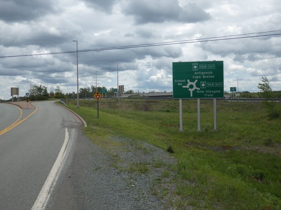
I went one turn too far, cost me maybe 10 minutes to get back on the correct road.
I went one turn too far, cost me maybe 10 minutes to get back on the correct road.
12-03-25 | 06:07 AM
#11
aka Timi
Joined: Feb 2009
Posts: 3,611
Likes: 325
From: Gothenburg, Sweden
Bikes: Bianchi Lupo & Bianchi Volpe Disc: touring. Bianchi Volpe: commuting
Although I love Komoot, I find it sometimes gets confused by roundabouts.
I usually ride just with audio cues, but will check visually after a complicated roundabout if my spidy-senses go off.
Fortunately after a hundred metres or so Komoot will say �You have left your route. Check the map (dumbass)�
I usually ride just with audio cues, but will check visually after a complicated roundabout if my spidy-senses go off.
Fortunately after a hundred metres or so Komoot will say �You have left your route. Check the map (dumbass)�
 12-03-25 | 01:00 PM
#13
Senior Member
Joined: Feb 2010
Posts: 1,142
Likes: 261
From: NH
I like paper maps for the big picture. Like Jamawani, I like to spread the map out on the picnic table at camp to plan several days ahead. I prefer digital tools for close up detail. Komoot shows intricate detail when you zoom in close, however it's vague at the wide level.
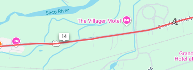
RWGPS has the irritating habit of obscuring local road names and numbers with its red route highlight. Details are not visible until you zoom way in ...
RWGPS
Even on a highway. US 302 is hidden by the red line ...
RWGPS
RWGPS has the irritating habit of obscuring local road names and numbers with its red route highlight. Details are not visible until you zoom way in ...
RWGPS
Even on a highway. US 302 is hidden by the red line ...
RWGPS
Last edited by BobG; 12-04-25 at 08:39 AM.
12-03-25 | 02:01 PM
#14
bicycle tourist
Joined: Dec 2007
Posts: 2,629
Likes: 470
From: Austin, Texas, USA
Bikes: Trek 520, Lightfoot Ranger, Trek 4500
For me personally, it depends on the tour. Last summer I rode Prudhoe Bay to British Columbia using only a GPS since there are like 6 roads total. If you get lost, you really should not be riding. If I feel I will "go off route" or if I am in an area with lots roads (like the Northeast) I bring a state paper map. However, I am definitely relying on paper less and less since Google maps is my backup to the GPS. Since my GPS collects all the data I want (distance travel, elevation climbed, grade of climb, etc.), I have for 10+ years used a GPS as my bike computer (cyclometer to the old timers). Of course, Google Maps is the best at locating services, though their search results drive me crazy when it (frequently) includes places that are no way related to my search. You would think that when you search for a bicycle shop a coffee shop would not be a top result.
I do have a Garmin running, but in examples of my riding from Prudhoe Bay to British Columbia, I haven't always downloaded a route to it. Instead, it becomes more of an odometer recording. The paper I like using in this case is a copy of The Milepost to get ideas of services/stops along the way.
In a more densely populated area, I am more likely to load a route into my bike computer. I don't keep a cell phone turned on, but I am also more likely to stop in a city and pull up an offline map (e.g. MAPS.ME, Organic Maps) to figure out exactly where I am - than try to rely on a paper map.
As far as Google Maps goes, agree with its use in finding services - though *for navigation* it is much more limited. The other uses I make of it is for time/distance budgeting. When planning a trip, I'll see what "Google Maps automobile route w/o highways" gives as distance. I might or might not actually ride that particular route - in sparsely populated area it might be *the* route but I'll at least have a distance approximation. I might also turn on bicycle instructions to get a rough metric of how hilly a route is (in countries with this info) - and again not ride that particular route.
So in summary:
- paper more likely in sparsely populated
- electronic more likely in densely populated
- offline maps as consultant when I am uncertain
- google maps for budgeting (distance, climb) and finding services
- gps recording but not always with a route downloaded
12-04-25 | 07:34 AM
#15
Senior Member
Joined: Aug 2010
Posts: 12,753
Likes: 2,112
From: Madison, WI
Bikes: 1961 Ideor, 1966 Perfekt 3 Speed AB Hub, 1994 Bridgestone MB-6, 2006 Airnimal Joey, 2009 Thorn Sherpa, 2013 Thorn Nomad MkII, 2015 VO Pass Hunter, 2017 Lynskey Backroad, 2017 Raleigh Gran Prix, 1980s Bianchi Mixte on a trainer. Others are now gone.
For purpose of this thread, I considered the term "navigation" to mean knowing where you are, knowing where your objective for the day is (which may change on a moment notice), and knowing when to turn or go straight. As I noted above in a previous post, I use paper maps and GPS.
Some of the discussion here is broader and includes "big picture route planning", perhaps months in advance, or maybe only a day in advance. For purposes of that I use several other tools besides my "navigation" tools. And my planning tools have changed over time as electronics and software databases have gotten better.
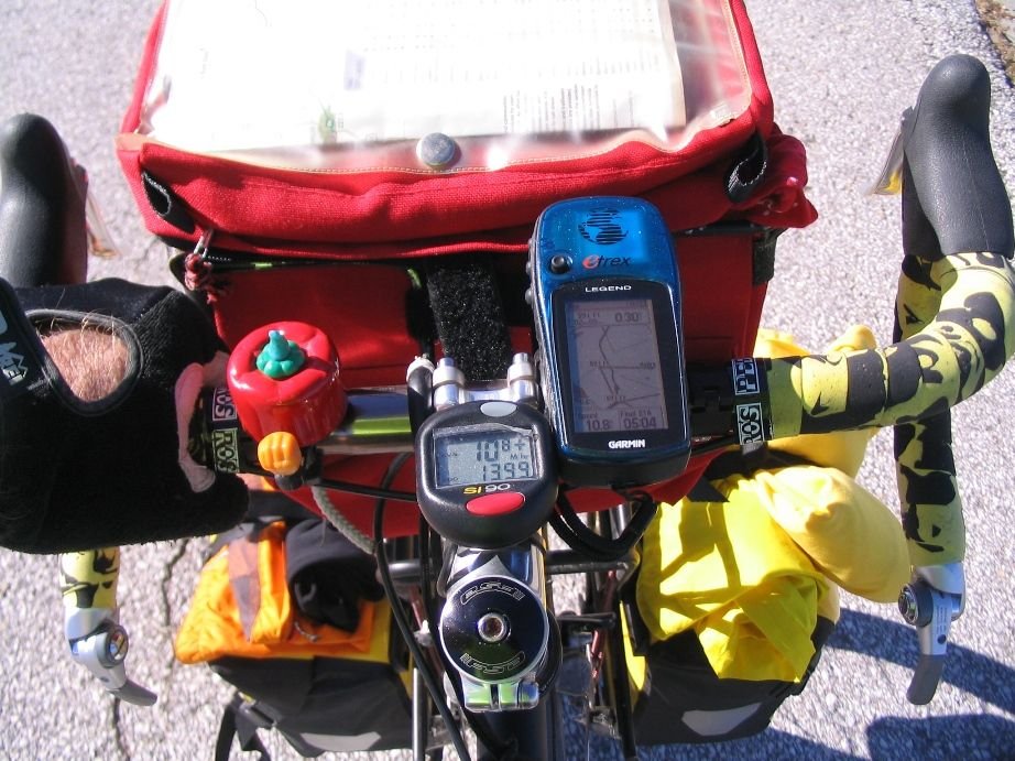
I was an early adopter of GPS, photo below was taken in 2010 on the Katy Trail. (At that time my 3 megapixel camera was considered high end.)
Thus, for over a decade and a half, have been using paper maps and GPS. But since then I upgraded the GPS to color screen, etc.
Some of the discussion here is broader and includes "big picture route planning", perhaps months in advance, or maybe only a day in advance. For purposes of that I use several other tools besides my "navigation" tools. And my planning tools have changed over time as electronics and software databases have gotten better.
I was an early adopter of GPS, photo below was taken in 2010 on the Katy Trail. (At that time my 3 megapixel camera was considered high end.)
Thus, for over a decade and a half, have been using paper maps and GPS. But since then I upgraded the GPS to color screen, etc.
12-04-25 | 07:44 AM
#16

Rider. Wanderer. Creator.
Joined: May 2007
Posts: 2,979
Likes: 4,266
From: New Jersey
Bikes: Bike Friday All-Packa, Zizzo Liberte, Ozark Trail G.1 Explorer
This ruggedized, $120 Android phone has a big 10,000mAH battery and good-sized speaker for listening to music on lonely roads. It's got maps for multiple states downloaded and music downloaded so it doesn't need a data plan and is usually in airplane mode but with GPS on.
It's been pretty good, but the SOC is pretty slow. If I were to do it again, I'd splurge for a faster unit.

I'm still waiting for a computer with decent-sized flexible display that can be folded up and stuffed in a handlebar bag.
It's been pretty good, but the SOC is pretty slow. If I were to do it again, I'd splurge for a faster unit.
I'm still waiting for a computer with decent-sized flexible display that can be folded up and stuffed in a handlebar bag.
__________________
Rider. Wanderer. Creator.
JohnMFlores.com | YouTube: JohnMFlores
Insta: JohnMichaelFlores | Substack: https://followingwyman.substack.com/
Rider. Wanderer. Creator.
JohnMFlores.com | YouTube: JohnMFlores
Insta: JohnMichaelFlores | Substack: https://followingwyman.substack.com/
 12-04-25 | 08:22 AM
#17
Senior Member
Joined: Jul 2010
Posts: 13,919
Likes: 1,243
From: Montreal Canada
Im evaluating a Coros Dura GPS unit currently, got it on sale 2 weeks ago, claims it has 120 hours of run time plus whatever the solar adds. Thats easily a week or more on tour. Can download RWGPS routes. Some funky setup quirks that I finally got squared away. The screen is not as big as a Garmin 1050, not sure it matters. Does turn by turn. Seems like a well thought out unit for a lot less than a Garmin. Will see how it goes.
Price here in Canada is about $400, very much in line with the garnin and other equivalents.
12-04-25 | 08:33 AM
#18
Senior Member
Joined: Jul 2010
Posts: 13,919
Likes: 1,243
From: Montreal Canada
while I still like having a paper map if possible as a backup if necessary, realistically using a gps or google maps on my phone for check ups is pretty much the norm nowadays.
As a bunch of old farts here, I think even the majority of us have come to the realization that the tools we have available now are super useful and just plain work.
I figure its an added bonus having the background of using only maps can help sometimes having a bigger picture thing going on in our heads, or to use if there is a technical issue, but really, modern navigation is fantastic and makes all the off road, back country trips we do so much more doable and simple.
If all of a sudden all the satellites go kaput, we are all fracked, but hey, thats unlikely, and we'll figure things out.


 12-04-25 | 09:15 AM
#20
Senior Member
Joined: Jul 2007
Posts: 8,625
Likes: 3,541
From: South shore, L.I., NY
Bikes: Trek Emonda SL7, Cannondale Topstone, Miyata City Liner, Specialized Chisel, Specialized Epic Evo
while I still like having a paper map if possible as a backup if necessary, realistically using a gps or google maps on my phone for check ups is pretty much the norm nowadays.
As a bunch of old farts here, I think even the majority of us have come to the realization that the tools we have available now are super useful and just plain work.
I figure its an added bonus having the background of using only maps can help sometimes having a bigger picture thing going on in our heads, or to use if there is a technical issue, but really, modern navigation is fantastic and makes all the off road, back country trips we do so much more doable and simple.
If all of a sudden all the satellites go kaput, we are all fracked, but hey, that's unlikely, and we'll figure things out.
For use of ANY GPS in an unfamiliar area, the maps are useful, though a paper map is easier and shows more info, except your current position and only a GPS can tell you that, thus the usefulness.
12-04-25 | 01:03 PM
#21

Senior Member
Joined: Aug 2005
Posts: 4,082
Likes: 392
Because I tend to stay on back roads as much as possible, finding paper maps which are that detailed can often be difficult. Hence I tend to make use of Electronics and my Limited Tech skills, a dangerous combination at times.
12-04-25 | 01:50 PM
#22
Senior Member

Joined: Jan 2010
Posts: 45,398
Likes: 23,569

 12-04-25 | 06:44 PM
#24

Full Member
Joined: Jul 2023
Posts: 456
Likes: 272
From: Montr�al
Bikes: Hardrock touring bike
12-04-25 | 06:50 PM
#25
Full Member
Joined: Jul 2023
Posts: 456
Likes: 272
From: Montr�al
Bikes: Hardrock touring bike
I never understood why the new-fangled roundabouts around here work opposite to those in Europe which have been around since forever. Here cars entering the loop have to give way to those going around so sometimes you can never enter.
Last edited by Paul_P; 12-04-25 at 06:59 PM.